Some of the best examples of Idaho’s marine Paleozoic fossils are found near the summits of mountain peaks (10,000 feet of elevation and higher). Although they appear in carbonate formations throughout East Central and Southeast Idaho, the core zone is in the Southern Lemhi and Lost River Ranges. Specifically, the best preserved fossils are found in the Scott Peak Formation of Mississippian Age. 330 million years ago, this part of Idaho was a shallow subtropical sea far to the southeast, part of the super continent Gondwanaland.
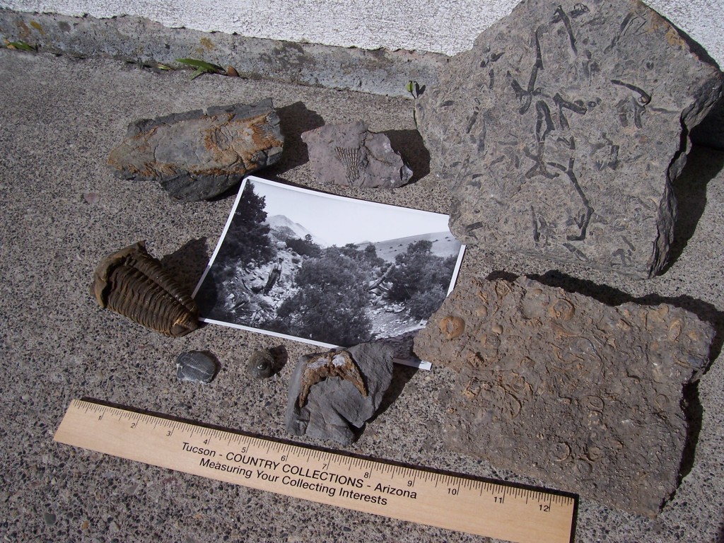
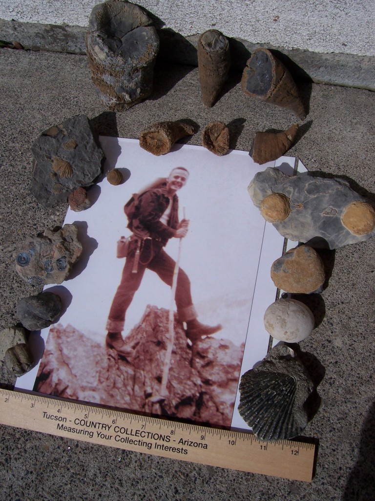
It was not an easy journey to the present for these coral reef relics. Only those that were quickly buried in lime muds and survived being eaten, baked, burned, squashed or torn asunder have survived. No soft body parts remain, and what we see is not the original shell-y part. This has been chemically replaced by silicates and iron oxides. Fossils allow us to see and touch the incredibly distant past. This visualization can also be enhanced by the sense of smell. Crack open a piece of black fossiliferous limestone. The sulfur dioxide (rotten egg) smell is another remnant of the decayed organism. The following 3 photos each depict a pioneer Idaho geologist and a suite of fossils he likely found in the course of his fieldwork.
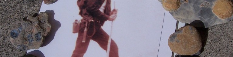
JOSEPH B. UMPLEBY (1883-1967). Dressed in his “survey tans,” US Geologist J. B. Umpleby is ready to leave camp on his mount for another day in the field, somewhere in Lemhi or Custer County (circa 1912). Colony coral is found on the summit of Umpleby Peak (10,713 feet). Fossils clockwise from lower left: Foraminifer; Bryozoan mass; next 5- colony coral (Tabulata); next 3- Crinoid (sea lilly) showing head, stem length and star-shaped axial cross section of stem; spicule.
CLYDE P. ROSS (1891-1965). A prolific writer of Idaho geology, 1947 was a banner year for US Geologist C. P. Ross with his publication of “Geology of the Borah Peak Quadrangle” and “Geologic Map of Idaho.” Here he is pictured in Sawmill Canyon (Lost River Range) with White Cap Peak in the background (early 1930s). The bony fish was found en route to Clyde Ross Peak (11,724 feet). Fossils clockwise from bottom center: Streptelasma; Gastropod; 2 Trilobites; bony fish; 2 Archemedes-fan and stem mass, Coquina (limestone biomass).
OSCAR K. HUH (1935- ). O. K. Huh did his Penn State doctoral field work in the Lemhi Range, shown here in the Diamond Peak area (1959). Huh specialized in the Mississippian limestones and defined 4 new geologic formations, including the Scott Peak. You guessed it, Horn Coral fossils are found around Huhs Horn (11,292 feet). Fossils clockwise from lower left: 2 Productids, Orbiculoidia (with original blue sheen?); Spirifera-these are all Brachiopods; 6 Horn Corals (Rugosa) of various sizes, 2 show in tact septa. Horn Coral disappeared with the Permian Extinction, but as members of the Coelenterate family they are survived today by the jellyfish. Pelecepods (clams).
All material is from the Rick Baugher collection (April 21, 2007).
The history, evolution and process of naming mountains is discussed on Pages 32-33 of the book. However, the specific origin of official (and unofficial) mountain names is often not documented. The public can submit proposed names for peaks via the U.S. Geological Survey’s U.S. Board on Geographic Names website. But often, and especially before the Internet, names that were not officially designated through the Board tended to come and go with time. Now unofficial peak names are showing up on Google Maps and other websites, giving unofficial names some semblance of approval and permanence.
This page contains historical information (in alphabetical order) on the origins of Idaho peak names. Do you have an article or another document about the naming of an Idaho mountain? Share it with us through our update form and we will feature it here!
Fenn Mountain is one of the most impressive summits in the Clearwater Mountains and is one the peaks identified as the Selway Crags.
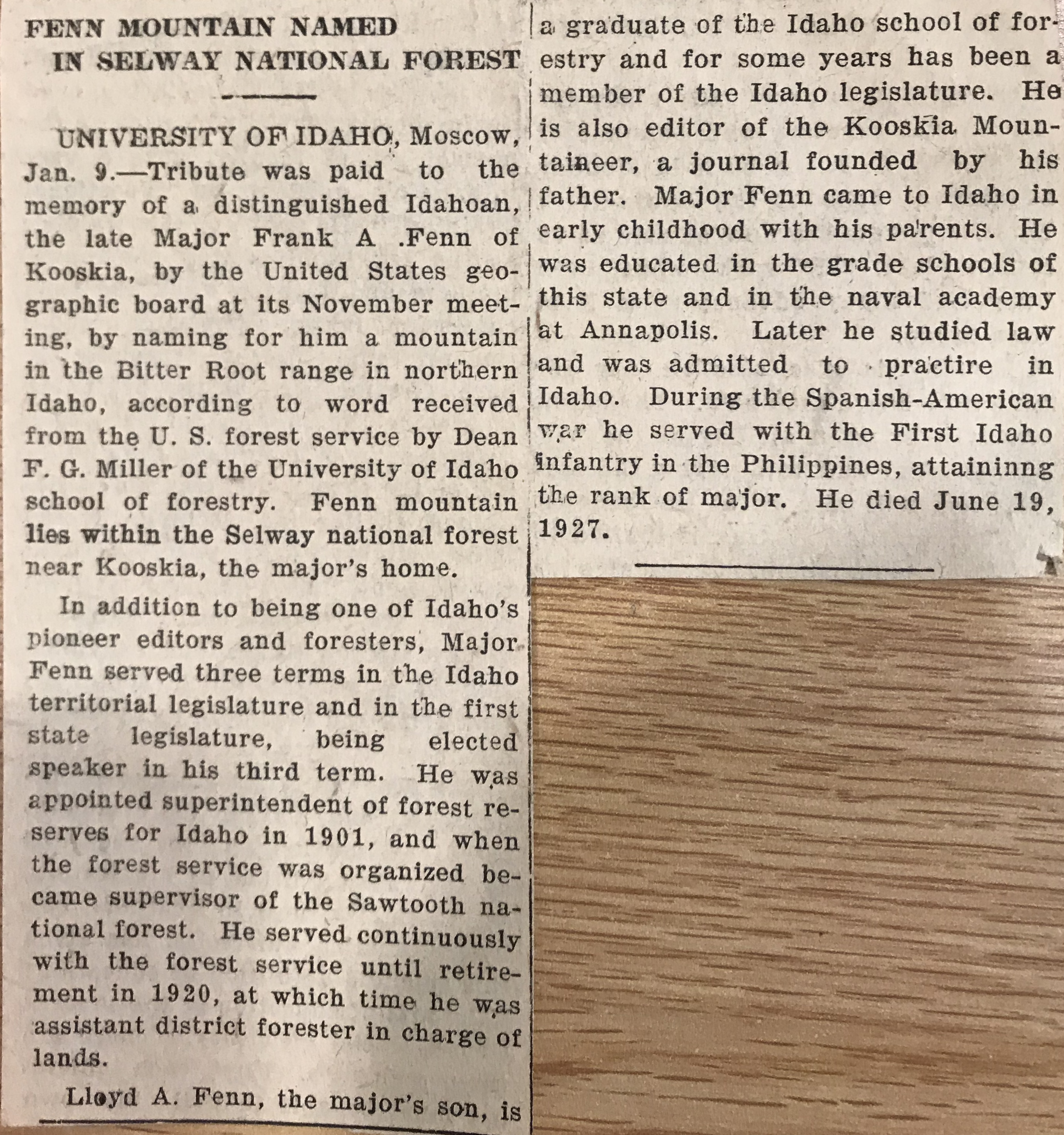
January 13, 1928. I believe this article is from the Idaho Statesman.
Frank Fenn was the first supervisor of the Clearwater National Forest headquartered in Kooskia that included all of the Lochsa-Selway country.Fenn had an illustrious career before taking up public forest management in 1901: he was a student at the first public school in Idaho, at Florence; was a cadet at the U.S. Naval Academy; was a participant in the Nez Perce Indian War of 1877; was Speaker of the House in the first Idaho Legislature; and was a major in the U.S. Army during the Spanish-American War.He retired from the Forest Service Regional Office in 1920 and moved back to Kooskia, where he died in 1927.
Major Frank Fenn with his wife Florence and son Lloyd. Date unknown. Penny Bennett Casey Collection, Nez Perce-Clearwater National Forests archives
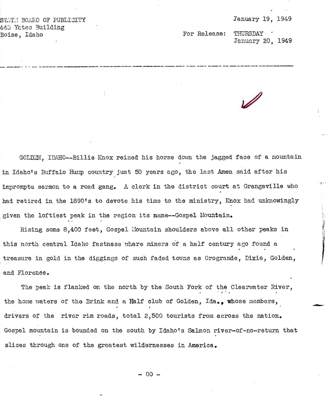
Gospel Peak (Gospel Hump Wilderness)
As explained in this 1949 press release Billie Knox is responsible for the use of the name “Gospel” for north Idaho two peaks, Gospel Peak and Gospel Hill as well as the Gospel Hump Wilderness.
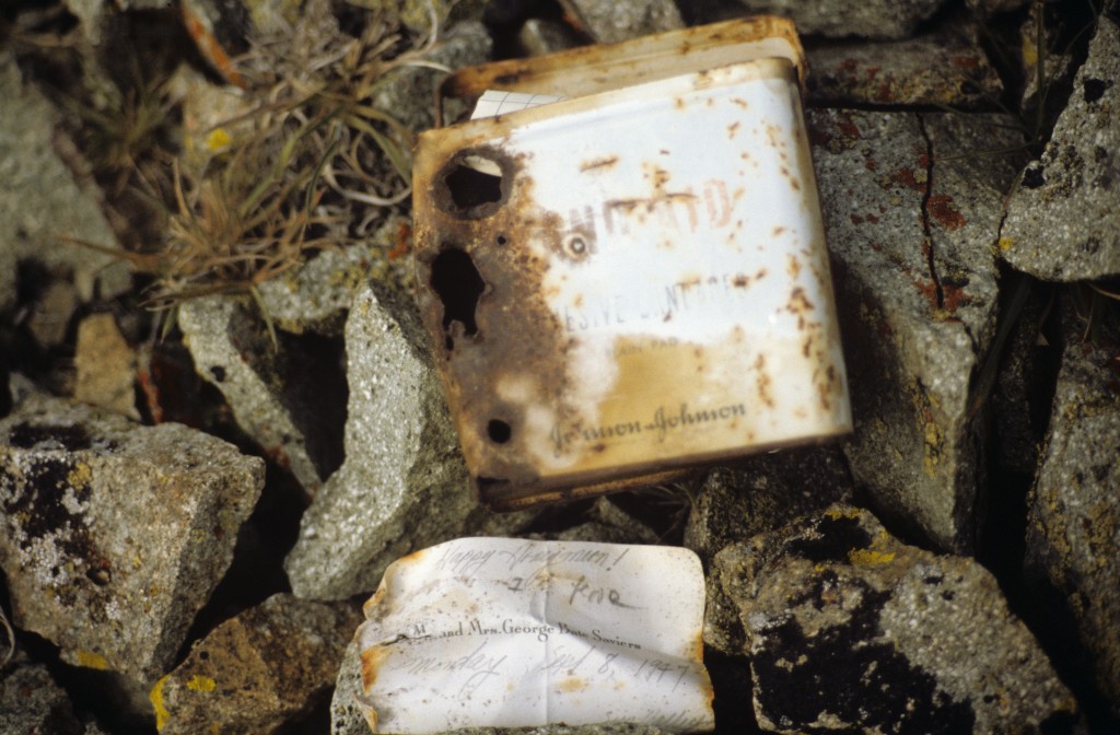
This is the register left by Mr. and Mrs. George Saviers who climbed the peak while on their honeymoon in 1947. Later climbers adopted the Saviers name for the peak.
The summit register found in 1987 and left by Mr. and Mrs. George Saviers who climbed the peak on their honeymoon.
This excerpt is from an Idaho Statesman Column by Dick d’Easum entitled “The Hills of Home.” The article shows an interesting side of the peak’s namesake.
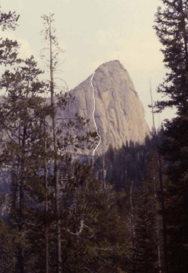
Idaho has nine summits that reach over 12,000 feet and all but two lie within the Lost River Range in central Idaho. Idaho’s tallest and most visited peak, Mt Borah (12,662’), is located in the central section of the range. As the state highpoint, it is also very popular. During the summer months, it is not unusual to see a full parking lot and 50 or more people attempting to climb the mountain by its most popular route, the Southwest Ridge, or “Chicken-Out-Ridge” as it is more commonly known. For some classic snow or ice climbing, Borah also offers several hidden gems on its North Face, including routes written up in past editions of this journal. In spite of all of the traffic the mountain has seen, the remote East Face remained relatively unexplored and unclimbed until the summer of 2011.
Geology
Idaho’s Lost River Range is an actively uplifting fault-block at the northern end of the Basin and Range province. Extensional faulting has lifted the range relative to the down-dropped Big Lost River basin on its west side, producing steep ridges and slopes essentially devoid of foothills. Interior and eastern regions of the range are deeply incised by the Pahsimeroi and Little Lost Rivers. Most of the range, particularly in the central and southern regions, consists of thick layers of Paleozoic limestone and dolomite. Multiple episodes of tectonic deformation have resulted in dramatic open to isoclinal folding at a scale of meters to kilometers. Glaciation has carved numerous cirques throughout the range and alpine lake basins are scattered in the central and eastern portions. These combined activities have created an impressive assortment of large, high angled faces with western, northern, and eastern aspects.
Background
I first visited the eastern side of the Lost River Range (The Pahsimeroi Valley) in 1972, while working on a helicopter contract for the Forest Service. Flying through the range provided me a view that few ever get to see. While all of the range is impressive from the eastern side, one face stood out from the others. When our contract with the USFS finished at the end of summer, I took a break from the 24/7 aviation life I was accustomed to. During this down-time, I happened to notice an ad for an introductory rock climbing class and thought, “Wow. Cool. Ropes and everything, I’m game for this!” I talked a couple of friends into joining me for the class. After completing our class, we were ready to test our newly learned skills on a real mountain but winter soon arrived and we put our plans aside until the next summer.
Summer came late in 1973. It wasn’t until the end of June that we were able to get in for a closer look at the East Face. As the morning sun warmed the snow high in the cirque, we watched slide after slide tear loose and nail virtually every approach to the mountain. Along with the snow slides came a lot of rock fall as well. After sitting and studying the face, it looked to be climbable. There was no doubt, however, that the attempt would have to be made during the dry season. In 1974 we returned for another exploratory trip and picked out a line on the face that followed some water streaks in a nearly straight path to the summit. We decided that this was the route we would attempt on our next visit.
A couple of years passed. In trying to sell potential climbing partners, I described this face as “Idaho’s Eiger” but at the time, the range had no technical rock routes. Idaho has so much fine granite it was hard to justify a trip to the Lost Rivers, where the limestone rock had a reputation for being nothing but choss. In the fall of 1975, Mike Weber and I decided to throw caution to the wind and give this face a serious attempt. We loaded up all of the gear we thought we’d need and made the brutal drive to the end of the road up the West Fork of the Pahsimeroi River. Hiking through open sagebrush, we made quick work of the approach and found a nice grass-covered spot for our camp at the lower tarn just above timberline. Curious to see the face up close, we grabbed our crampons and axes and headed up the snow and ice to where the bare rock began. Just as we were approaching the final section of snow and the start of our proposed route, we heard a rumble from above, freezing us in our tracks. A Volkswagen-sized rock was flip-flopping down the face. Within seconds, it reached terminal velocity bouncing back and forth down the face. We stood motionless in our stances trying to figure out if we should go left, right, or just clasp our hands and pray. Fortunately, the rock deflected about 40 feet to our right. We just stood there watching it tear up snow and bounce to the flats and the tarn at the bottom of the cirque. We tried to convince each other that the face would be frozen up by morning but neither of us was to be convinced. Around 2:00 am we were startled awake by a blinding flash of light and milliseconds later, a rumble of thunder. We both knew our chances to climb were most likely over, so we pretended to go back to sleep. Within minutes, the rain was falling at a rate of an inch or two an hour, and shortly afterward our campsite became a flood zone. We stayed in the tent until it was surrounded by flowing water, our cue to get the hell out of there.
For decades after that ill-fated attempt, my climbing partners and I continued to explore and put up routes in the range. Despite those many visits, we never made it back to the cirque. I pretty much wrote off the East Face as being a very dangerous place and that kind of risk no longer appealed to me. Also, as time progressed, I gained the impression that sport climbing and bolted routes on established climbs were the “new norm” and the pioneering of new alpine routes seemed to have gone by the wayside. It wasn’t until the spring of 2011, during a discussion of Lost River climbs on the Idaho Summits web forum that a new spark of interest began. When I first described the East Face cirque, most local climbers did not know what I was talking about. This, despite most of them having climbed Mt Borah multiple times. One did, though. After reading my description of the face, Wes Collins, a local climber and native of the area, immediately became interested. Soon, a new discussion started about taking a trip to the cirque.
First Ascent – The Dirty Traverse Grade III 5.4
Wes Collins (solo) July 2011
Wes couldn’t wait to see the face up close so he took off on an exploratory trip with his wife and dog. This trip in 2011 started as a recon, but Wes found himself drawn to the face like a magnet. The following is Wes’ account of the first ascent.
Bob got me all fired up to get a look at the eastern cirque and what he described as Idaho’s Eiger. I certainly wasn’t disappointed. Susan and I planned the trip as a leisurely backpack into Lake 10,204 to take in the views, but I tossed an axe and some light crampons in the truck just in case.
I spent a lot of time looking at the face before I even thought about a spot for the tent. Stupidly, I’d left my axe and spikes in the truck, but at this point I knew I was going to make a serious try for the summit. It didn’t take long to pick out a couple possibilities, but the most probable line would involve a long traverse across a talus-covered ledge on the lower face. I started thinking of the route as the Dirty Traverse before I even put my boots on it. Morning was an easy laid-back affair. We sipped coffee and we watched the sun line slowly make its way down the mountain. I had to wait until nearly 10:00 before the snow softened enough for step kicking. The first, lower snowfield was pretty firm, but the second was much softer.
I’d found a nice tooth-shaped chunk of limestone that probably wouldn’t have done much more than keep my feet down hill if I took a fall. I was on my own, but it was still embarrassing to have the damn thing in my hand and I had to keep fighting the urge to hide it in my pocket. At the top of the snow, the randkluft was several meters deep and the first tentative moves on rock over the blackness below felt pretty exposed. The rock, however, was surprisingly solid and clean.
The scramble to the traverse ledge was fairly sustained Class 4, but the rock was good enough to make me forget about the exposure and enjoy the ride. The traverse ledge was quite tedious though and I wasn’t sure it would go all the way to the ridge until I got there.
Once on the ridge I made my way up an easy Class 5 seventy foot buttress but it could have been easily bypassed by scrambling around its west side. Most of the ridge above the traverse is Class 3 or easier.
As I continued up the ridge, my doubts got bigger. The entire north side of the East Ridge is very tall and overhung in several places. More and more I suspected it would dead-end into the headwall but at the last possible minute, a tiny col opened up onto the uppermost ledge that crosses the East Face. It wasn’t till that moment that I knew the ridge would go all the way. Splattski summed it up nicely in his trip report of JT peak as the almost magical opening of doors as you climb. This was one of the most fun parts of this outing. I couldn’t agree more.
The descent follows the standard route down the mountain to the big saddle at 11,800. From there, I dropped into the cirque that takes in the south side of Borah and Mt. Sacajawea. There are several sections of Class 3/4 scrambling over short but loose cliff bands and several linkable snowfields, but the glissade run-out potential is pretty dangerous on most of the snowfields. At the 10,400 contour the angle eases up. From there I hiked down and around the bottom of the East Ridge and finally back up to camp.
The East Face Direct III 5.9
First Ascent Sept 24, 2011 Wes Collins, Kevin Hansen
Second Ascent Sept 19, 2013 Kevin Hansen, Larry Kloepfer
Start at the highest glacial lake in the East cirque and walk around the north side of the lake for easiest access. Angle your way around the bottom snow field and trudge your way up the scree until you reach the first rock band. This is an easy Class 2-3 scramble for 20 meters or so. Once on top, pick your path of least suffering up the scree to the bottom of the snowfield. Depending on where you choose, this class 2 scree slope is not friendly. Loose dirt and gravel are stacked at a 50 degree angle for a few hundred feet. Once at the toe of the snow field, find a place to strap on your spikes. The slope is around 45 degrees and it is wise to bring crampons. Depending on snow conditions, an alpine ice axe could help. Hop the randkluft and get onto the face. From here the world is yours. At first sight it looks like 80 percent of the East Face is 5.6 to 5.7 climbing which is a good rating for the first 4-5 pitches. East Face Direct follows a dark water streak that passes just left of the top of the “Super S” as Kevin called it. The “Super S” is a large obvious fold in the rock strata that composes the lower right quarter of the East Face. At any time, a team could climb side ways (off route) to the right or left a few hundred feet to avoid the more difficult sections. The direct route stays plumb with the top, following the dark water streak to find the best rock. Because most of the climbing is 5.6 – 5.7, groups may choose to simu-climb many of the pitches. Teams that wish to set up a solid anchor every rope length could discover the route is close to 9-10 pitches. As with all mountaineering, speed is safety. Several class 2-3 scree slopes divide the rock pitches. One short pitch was a solid 5.9 with a protection less small overhang. It’s the finest part of the route. Once past the final head wall, put the rope away and enjoy the last 300 feet of class 2-3 scrambling to the summit.
East Face/Northeast Ridge Variation III 5.6 WI2
First Ascent – July 25, 2012 Bob Boyles, Frank Florence
While this route is not overly difficult, it does require a willingness to climb with long run-outs and minimal protection both at belays and while leading. Many of our belays were protected with a single piece of gear and most pitches only allowed for a few placements. Rockfall, both self-initiated and trundled from the summit is an ever present danger on this route.
The route starts slightly to the right of Wes Collins’ Dirty Traverse route and follows the slab like ramps for about 6 pitches of 4th and low to moderate 5th class climbing until you reach the ledge system that allows for an exit to the Northeast Ridge. From there we climbed 2 pitches of very steep snow and joined the ridge. On the Northeast Ridge we encountered a short section of water ice (WI2) and several more pitches of moderate 5th class climbing until just below the summit, where it turns to easy, but very loose 3rd and 4th class climbing.
This route is probably best done when there is some remaining snow to cover loose scree and talus (June – July) and during some years it may not be climbable at all due to the large cornice that can form and block the narrow exit to the Northeast Ridge. Parties willing to solo or simu-climb can reduce the overall number of pitches required on this route.
Bob Boyles found and transcribed a scanned copy of the following 1929 article which discusses Mount Borah.
The Idaho Sunday Statesman
BOISE, IDAHO (SUNDAY MORNING MAY 29, 1932)
Where Gray Granite Crags and Idaho’s Azure Skies Meet
By DICK d’EASUN
Up at the top of Idaho, supreme among Gem state giants of massive rock, rules Mount William Edgar Borah, mantled now with robes of gleaming snow, defying the elements to cut away its towering battlements. Pounded by millions of years’ geological transformation, ground under the heel of a mighty, rolling glacier, the lofty peak stands bold and tremendous, Idaho’s challenge to the majestic Tetons, the Alps of America.
Not favored by the scenic beauty of thick timber, blue mountain lakes, and long vistas of granite crags rising abruptly from green forests that makes the Sawtooth Range and Lost River Mountains an inspiring wonderland, Mount Borah commands a little-traveled and only slightly-explored area of East Central Idaho. Though higher by nearly 600 feet than its closest rival, Mount Hyndman, the Dean of state mountains is not spectacular in its soaring glory. The surrounding area is of itself so high that the peak juts out unobtrusively and fails to attract the attention it would if its broad, steep sides of shale were cut in sharp relief in lower ground.
The mountain, named for Idaho’s senior senator, is 12,655 feet above sea level at its crest. It is located 6 miles east of Dickey, a junction point near Willow Creek on the Mackay-Challis highway. Plainly visible to all persons who pass over the road on clear days, Winter and Summer, the peak is seldom noted by scenery seekers, expecting to find something towering like a church steeple above a city street as the greatest of all crags within the state. From the Snake River Valley more than 100 miles to the southeast, the crest is occasionally glimpsed as a faint outline of dazzling white fading into deep blue of the lower ridges, marking the Pahsimeroi Range, the least-known territory of Idaho.
Several other points in the lofty ridge between Big Lost River and the Pahsimeroi Valley are only slightly lower than Mount Borah. For some years, it was believed that a peak to the south, not named, was the zenith, but since observations and measurements have been taken from Borah’s cloud-wreathed brow, it has been determined that the senator’s namesake is the King, the Lord of Altitude.
When the peak was first scaled by a Government party in 1912, a bronze tablet was fixed at the top and the latitude and longitude were determined and inscribed. For survey purposes, the point was designated as the Beauty triangulation station, the name which is found on most old forestry and other Government maps. The peak lies within the Lemhi National Forest.
During the Summer of 1929 while mapping the Bayhorse quadrangle (an area north and east of Mount Borah), a party of 3 engineers and geologists of the Idaho Bureau of Mines and Geology made several special Sunday trips to investigate the Pahsimeroi giant. Thomas H. Hite, assistant geologist and John T. Carpenter, field assistant scaled the peak and tramped through surrounding ledges and crests gathering information on rock compositions. Triangulation and determination of altitude was done by Lee Morrison, topographer of the United States Geological Survey.
Many bearings and readings of angles were required from previously-located altitudes known as “benchmarks” and “triangulation stations.” Figures were sent in to the United States Department of the Interior/Geological Survey Department and in December of the same year, the mountain was christened one of the oldest points in the state in geological respects and the newest among named peaks, being less than 3 years old.
Ascent of Mount Borah is not particularly difficult, and not to be compared with scaling attempts on Castle Peak, Cathedral Rock (Heyburn Peak) or the hazardous climb up the Grand Teton, Wyoming’s pride and the toast of Jackson Hole. Access to the summit of Borah is not readily gained from the West Slope but a fairly good hiker should have little trouble making the trip. Because of snow which lingers long at the summit on the North Side, the best time to scale the peak is in August or September. Even then patches covering 2 or 3 acres remain unmelted. On a climbing trip in September 1929, Hite, Morrison, T. T. Smith and Bert Buchanan (members of the Morrison topographic party) outlined the route now generally taken.
The party left Challis in an auto, driving to Dickey and over Doublespring Pass where two large cold springs merge a few feet apart. From the pass, the engineers continued to the east and then south to Mahogany Ranger Station which has an elevation of nearly 9,000 feet. After following the road until it became little more than a trail, they were forced to leave the car at a sheep camp and start out on foot. A trail up Leatherman Pass leads to the rugged ridge on which Mount Borah has its throne.
By working up the rugged ridge, a gradual slope, the summit was reached within a few hours. On either side, sheer cliffs drop away hundreds of feet and gigantic slopes of shale rock stretch away miles and miles down into the canyon to the west. To the east, the country is more wooded and sharp, giving way in the distance to the Pahsimeroi Valley and the typical frontier town of May, where the Old West lives on as glamorous as ever.
Comparatively few people have been to the top of Mount Borah but the peak is becoming more popular. The view commanded is magnificent. Craters of the Moon are 50 miles to the southeast. Nearer lie rough mountains, high valleys, glacial lakes unexplored and some of the most remarkable geological wonders in the state. Rolling mounds of glacial gravel, Paleozoic strata composed of quartzite and limestone are said to be hundreds of millions of years old, an inconceivable period. The formations were folded into a great arch or anticline in comparatively recent (tertiary) geologic time. A “V”-shaped valley, clearly gouged from mountain peaks by forces of nature and plainly visible from Mount Borah and nearby points, was carved by the Great Ice Age. Glacial moraine is noticeable in all directions.
Three thousand feet below the top, straggly timber gains a foothold and there are patches of forest here and there a little lower down. Swift streams pour down the sharp declivities and bright eyed rock conies frisk among the shale near their icy banks. Off to the southwest looms Mount Hyndman (12,078 feet), for many years thought to be the highest peak in the state. Each peak is visible from the other.
On clear days, from the summit of Mount Borah the sharp spire of Castle Peak may also be seen. This peak, owing to its cone shape and visibility from a great distance, is among the more prominent crags of the state. It is very difficult, if not impossible, to scale. Castle Peak (like Mount Borah) lies in Custer County. Rivals of greater charm than ancient Mount Borah are found in the Sawtooth Range where Decker Peak and Cathedral stand out like gigantic teeth of a cross-cut saw against an azure skyline and catch each glint of a gorgeous crimson sunset. Yet Mount Borah stands triumphant, unbowed by time’s crushing blows, guarding the wild Pahsimeroi, holding the secrets of eons in its scarred, proud shoulders Idaho’s most successful thrust toward the infinite blue of unattainable heaven.
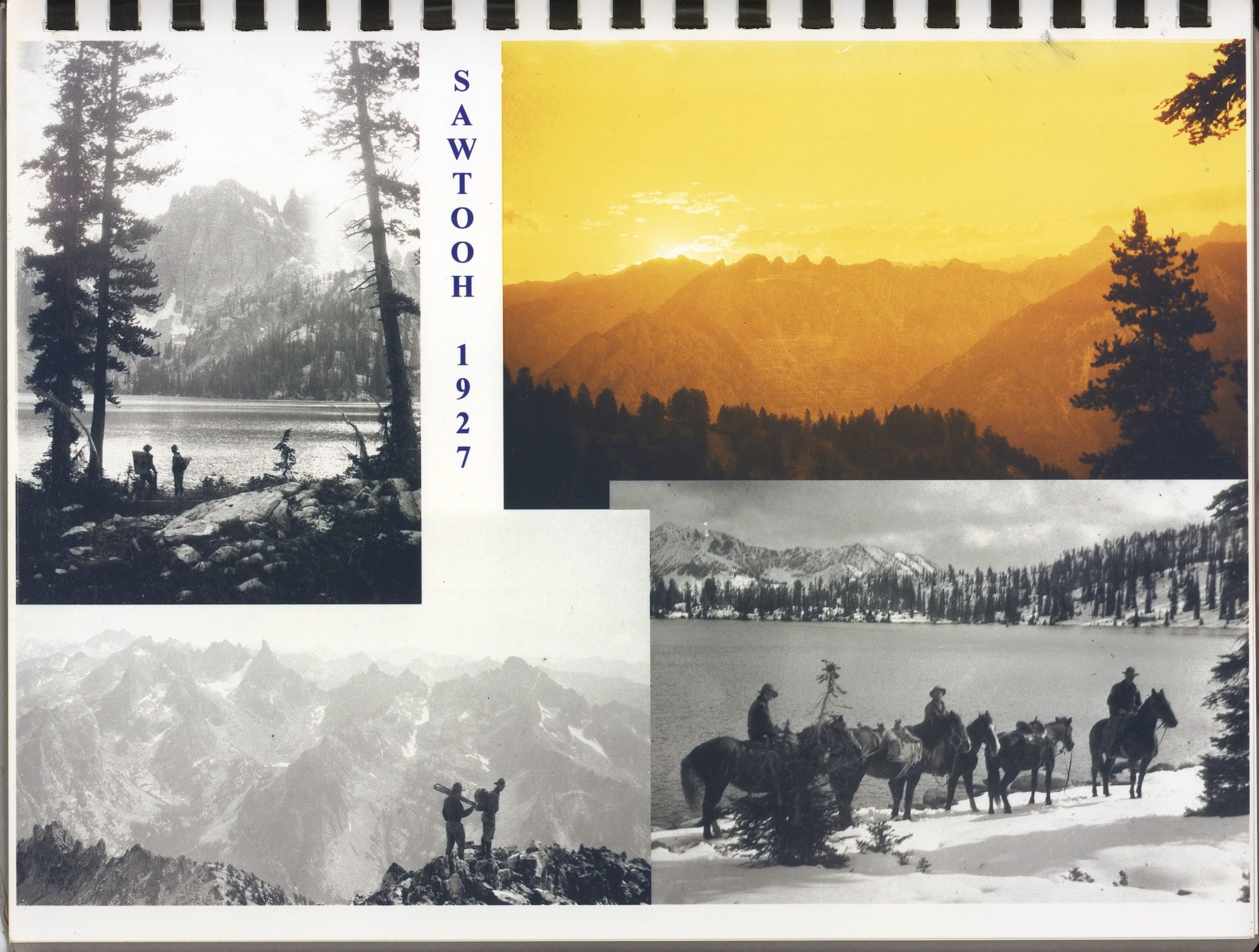
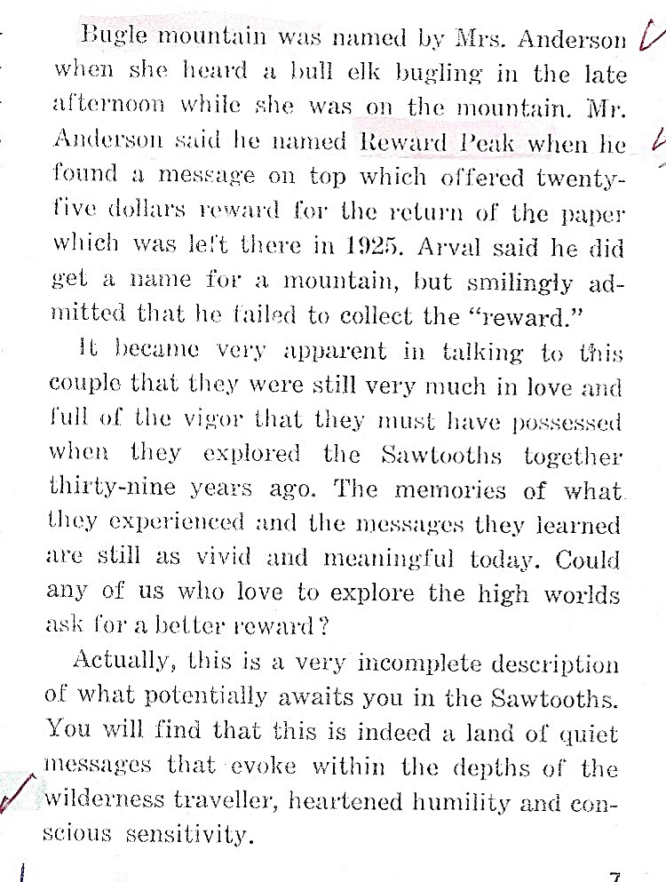
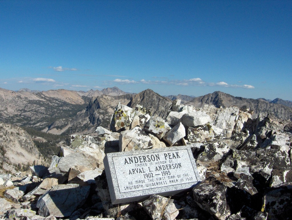
Arval Anderson, a civil engineer, was an early USFS Surveyor who was stationed in the Boise Mountains and Sawtooth Range in 1927. He is responsible for naming Tohobit, Reward and Bugle peaks among others. This entry covers a bit of Arval’s history which is quintessential Sawtooth History. There are three entries below: (1) a portion of a 1983 USFS interview, (2)”What we did on our summer vacation” by Arval Anderson, (3) an excerpt from a 1967 Summit Magazine article and (4) correspondence between Idaho climber Dave Pahlas and Arval’s family. The family has tried to have Peak 9704 in the Sawtooth Range backcountry named after Arval since 1976. This website unofficially uses the name “Anderson Peak” as Mr Anderson undoubtedly is worthy of the honor. The family has climbed the peak on numerous occasions and left a monument on the summit. The naming effort began in 1966 long before it’s location was in a designated wilderness.
(1) 1983 Forest Service Interview.
My first work that summer of 1926 was in surveys and maps and on my first field assignment I left Ogden about July 10th and traveled by train and bus to Robinson Bar which is near Stanley, Idaho. That’s where I first met Henry Shank who was Chief of the Surveys and Maps section of Engineer- ing, and my first boss in the Forest Service. I was to help him on a triangulation job in which we were to locate the geodetic positions of all the lookouts on the Boise National Forest, plus a few other peaks for mapping control. We actually started working on the Challis Forest. The Sawtooth range of mountains is located west of Stanley and marks the dividing line between the Boise and the Challis National Forests. The Sawtooth Forest lies to the south.
Shank and I started on this triangulation job and then about the latter part of July, while we were on a pack trip into the area west of Stanley, on the head of the Boise River, Henry came down with a severe cold and headache. he apparently had sinus trouble, so we returned to Stanley. Henry decided he must return to Ogden and turned the job and his car over to me. I took him the sixty miles to Ketchum (today’s Sun Valley) where he caught a train to Ogden.
Henry had hired a young fellow, named Bobby Allen, probably 17 years old, to be my assistant. He was the son of Ed Allen who was the Forest Ranger at Stanley at that time. Bobby Allen and I took Henry Shank’s Model T Ford Coupe and started out to complete the triangulation work on the Boise Forest. We occupied about ten peaks, most of them were actually lookouts, on the Boise Forest. However, Henry and I had already occupied a couple of the rugged peaks in the Sawtooth Range: Snowyside and Thompson. We also had occupied Wolf and Swanholm on the pack trip when he got sick.
The first is a photo taken during the 1927 mapping project which shows Arval Anderson on the summit of a peak in the southern Sawtooth Mountains with his plane table and alidade. Arval Anderson Family Collection
The triangulation work required setting up a transit on each peak and reading and recording the horizontal angles between all the other desired peaks that could be seen. During the following winter in the Regional Office, I did the geodetic computations to determine the latitude, longitude, and elevation of each peak or lookout. The triangulation job included tying the network in to two Coast and Geodetic Survey second order stations. They were, Squaw Butte, north of Emett and Shafer Butte, north of Boise.
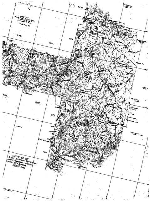
Besides locating the lookouts, the primary purpose of the triangulation was to establish control for a mapping project to be done in 1927. The area to be mapped included a total of about 600 square miles on the eastern side of the Boise National Forest. I was to map, by plane table method, 310 square miles on the northern part of this area, and another man. Major Simons, was to map the southern portion. Therefore, in addition to the goedetic computations. I prepared the plane table sheet on which I was to do the mapping in the field the following summer. About two-thirds of my area included the most rugged part of the Sawtooth Mountains. which are the most rugged in the state of Idaho.
FS: On the triangulation job. did you travel entirely by car?
AA: When Bobby Allen and I did the triangulation work. we would drive as close as we could get the car to where we were to occupy a point. If it was too far to hike and carry our instruments, we would rent horses from some local rancher. Most of the time we could make the trips within a day from where the car would be and I don’t recall that we camped out on that particular part of the work. On the actual mapping work in the summer of 1927 we had two parties on the Boise Forest. I had the northern part (310 square miles) which included the rugged country of the Sawtooth Mountains which I have described.
Arval Anderson Family Collection
The summer of 1927, I made the map by using the plane table and alidade method. The 24″ x 31″ plane table was mounted on a tripod. The alidade, an instrument with an eight-power telescope with cross hairs and a level for reading vertical angles and a straight edge base for marking directions, was used on the plane table. I sketched the topography and drainage directly on the sheet I had prepared during the previous winter. I maintained control by sighting in on control points by means of the alidade.
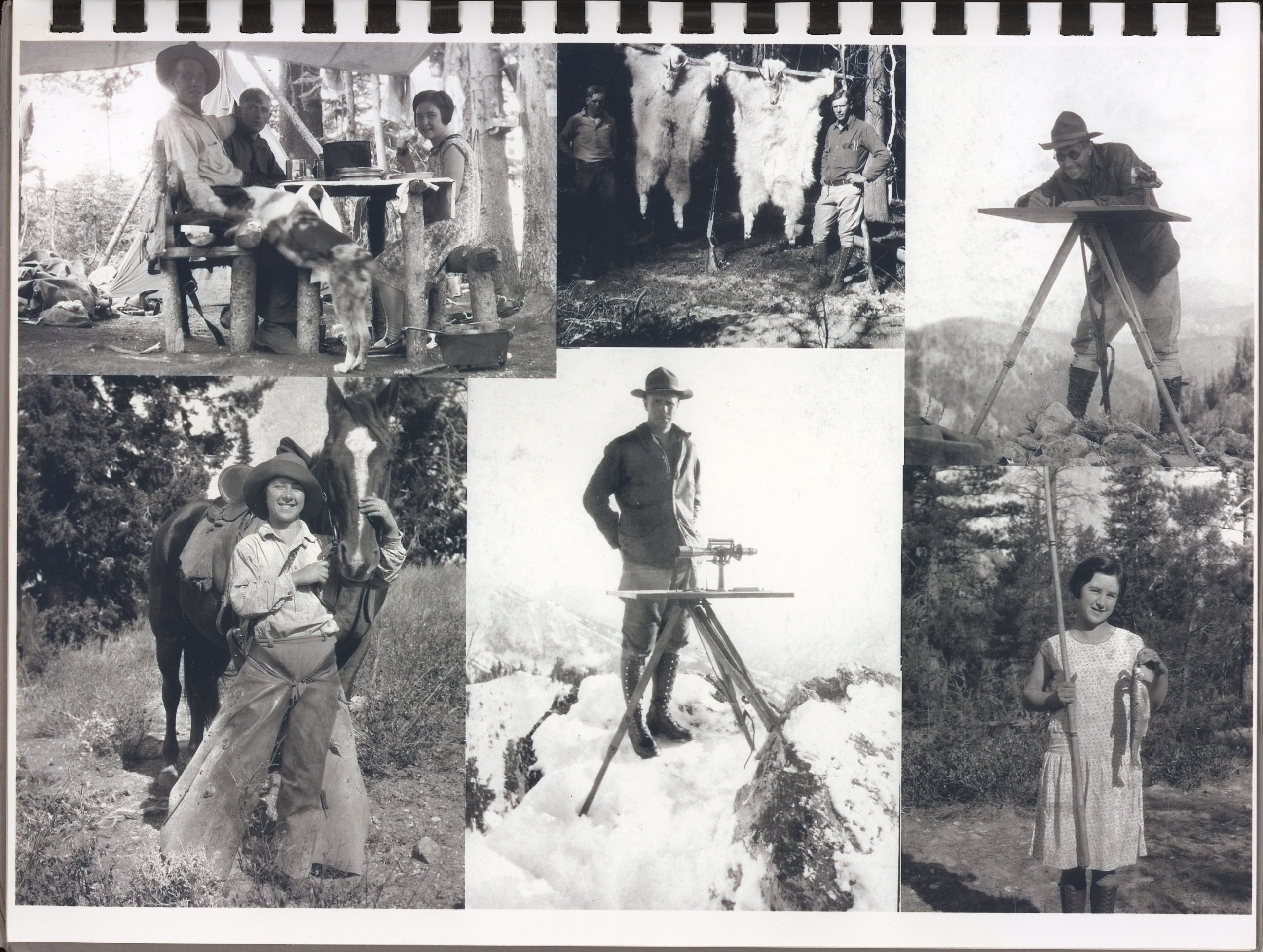
During the mapping operation we set bronze tablets on fifteen of the control peaks in the area. This required carrying a four pound hammer and a star drill to drill holes in the rock and a pound can of cement plus water for mixing, in order_to fasten the tablet. Our method of transporta- tion was horseback and on foot. We used pack-horses to carry our camp equipment and supplies. My party consisted of a field assistant, a combined cook and packer, and my wife, Maysel. We had many interesting experiences on that job so I will highlight a few.
Arval Anderson Family Collection
First, to look at the background of my party: As previously men- tioned. I had grown up in a logging town in northern Idaho and my field assistant was my younger brother, Joel. We were both woodsman and lumberjacks, so “roughing it” was nothing new to us. In our home town it was normal to have three to four feet of snow and thirty degrees below zero weather in the winter, with no indoor plumbing. My wife, Maysel. had grown up on a large wheat ranch near Moscow, Idaho, where her father also raised many horses. She. therefore, was an experienced hand with horses. I should also add that I grew up with horses, and in the summer of 1922 I worked as a packer for the Clearwater Timber Protective Association. using horses and mules to carry supplies to forest fire fighting crews.
Our packer, Hank Holverson, with three saddle horses and seven pack horses, from Challis, met us at Stanley about June 22, 1927. We packed up our surveying equipment. camp gear, and grub supply (from the Gillespie store in Stanley) and started over the mountains to the South Fork of the Payette River to begin our mapping job. Among our ten head of horses, three were half broke broncs. To get into the South Fork of the Fayette we were required to make a big detour to the north, as there was too much snow on Trail Creek Summit. As it was, we were delayed by rains, high water, and unruly pack horses. We took our horses over some patches of well packed snow, several feet deep and hard enough to support the horses. Altogether, it took six days to get to our first camp site on the mapping job. It was on the South Fork of the Fayette River near Baron Creek.
The 310 square miles I had been assigned to map contained about 200 square miles of country that was too rugged to traverse with horses. The result was that Joel and I were required to do much of our travel on foot. The average closest distance we could get a horse to the peaks we occupied for map sketching was about two miles. On a few occasions we would carry our surveying equipment, food, and bedding on our backs and stay out over night. On those “back-packing” trips we each carried about forty pounds while traveling and climbing over terrain too rugged for horses. It was literally “mountain goat” country and we saw many of them on this job.
Arval Anderson Family Collection
Because of the extremely rugged terrain, my progress on mapping was much slower than it would have been in average mountain terrain. It, therefore, took until November 19th before we were able to get out of the mountains. We had much rain, snow, and cold weather during September, October, and November. Our living conditions could be considered quite rigorous. We slept in 7′ x 7′ tepee tents with a canvas floor. We had no air mattresses or sleeping bags. We used evergreen boughs to make our beds less hard, and World War I Army blankets for bedding. Many nights in the fall it was cold enough to freeze our eggs into solid chunks of ice and our canned food was often frozen solid. Many a morning our wet boots were frozen stiff, so that we could not put them on until we had built a fire and thawed them out.
We had no camp stove and no tent to live in. although we did have a small wall tent to keep supplies in. All of our cooking was done on an open fire at the edge of a canvas “fly” which we had stretched overhead to cover the table on which we ate. It provided us with shelter from rain or snow and also shade from sunshine. Maysel became quite adept at keeping our sour—dough pot going for hot cakes and bread.
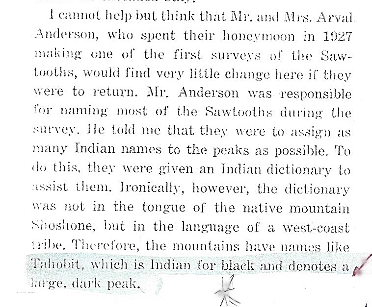
Another unique feature of this job was the fact that many of the mountain peaks, streams, and lakes in our area were not named. I was, therefore, instructed to name those that I believed warranted naming. I was not allowed to name them after any of our party or other people unless there was a bona fide reason. I was provided with a dictionary of American Indian words to apply in order to help perpetuate such words. We first adopted names that had local usage. This meant little. as nobody lived in the area I mapped. Much of it is now in the Sawtooth wilderness area. We named many of the peaks. streams. and a few lakes. There were more than a hundred lakes, but most of them were too small to warrant a name at that time.
One of Arval’s maps. Arval Anderson Family Collection
At the conclusion of the mapping work I submitted a list of proposed names for topographic features. Those names were eventually approved by the National Board of Geographic Names in Washington, D.C. For examples of names: I occupied a peak in early November wading snow about two feet deep. While there, a snowstorm with gusty winds set in. I was forced to abandon efforts to sketch topography. I named the peak “Blizzard Mountain.” On another occasion Maysel and I were on top of a peak in the late afternoon and we heard a bull elk bugling in a cove below the peak. Maysel suggested the name “Bugle Mountain” which we adopted. Examples of Indian words are: “Nahneke” which means “goat,” and “Tyee” which means “chief.”
We completed the actual mapping job on November 12, from our last camp at the mouth of Mattingly Creek on the Middle Fork of the Boise River; about seven miles east of the small village of Atlanta. By that time, the snow on Mattingly Creek Summit had gotten so deep we could not get through it with our 17 horses.
The reason for the 17 horses is another unusual incident. I pre- viously mentioned Major Simons’ mapping party on an area adjoining mine to the south. The pack strings and saddle horses for the Simons mapping party and for mine were provided by the same man, Sam Hessen, in Challis. Be. as owner of the horses, hired both packers, who were then put on the Forest Service payroll at $100 per month each. However, Sam required my packer, Hank Eolverson, to furnish three horses, for which Sam would receive the pay from the Forest Service. Sam would actually furnish only seven horses in my string and get paid for ten at $10.00 per month per horse.
In early September Hank said he needed to go out to pack hunters before October 1st, when the deer and elk season would open. He told me that Sam had arranged to send in a replacement packer and three extra horses. With that assurance Hank took off with his three horses to ride the 100 miles to Challis. The replacement packet and horses were to meet him at Atlanta. No replacement packer or horses showed up and we operated for one month, until mid—October, with no packet and seven horses instead of ten. I should mention that we used hobbies and a bell to keep our horses near camp. In the meantime, the Simons party completed its work and released its packer and pack string which then appeared in my camp about October 15th with no prior notice. I then had a new packer and 17 horses. The name of the new packer was Heinie Blume. He remained with us to the end of the job.
Now to get back to our efforts to leave the area: After a second futile attempt to get the horses over Mattingly Creek Summit. we pulled in to Atlanta where I shipped out all of our surveying equipment. camp gear, etc. by parcel post. This meant it went from Atlanta by a horse drawn bobsled 16 miles over Bald Mountain Sumit to the little village of Rocky Bar. From Rock Bar it was carried by truck to Mountain Home and from there by train to Ogden. Maysel traveled the same route as a fare paying passenger on the horse drawn stage which carried the mail to Rocky Bar. then on a truck stage to Mountain Home. Idaho. From there. she took a train north to visit her folks in Pullman, Washington. The packer leading all his horses took the same route to Rocky Bar, but then went through Fairfield and Bailey to Challis; a trip of about 200 miles.
Joel and I used my Forest Service key to enter the Atlanta Ranger Station (the ranger had already gone out for the winter) and borrow two pairs of web snow shoes. We then set out to walk the fifty miles to Stanley, where my car awaited us. The snow on Mattingly Creek Summit was six feet deep as we crossed on our snow shoes a short time before dark. As we got down to lower altitudes and the snow only a foot deep we discovered tracks of a man. We followed the tracks (aided by a lantern we had made from a candle and a tin can) for a short distance, perhaps a mile, and they led to a small log cabin near the shore of Alturas Lake.
We entered the cabin and were very glad to find a bedroll hanging from the roof logs and a small cook stove in one corner of the cabin, there was also a table. It was obviously a line cabin for a trapper. We spent the night in relative comfort compared to sitting or lying by a fire all night which we had planned to do. The next morning after breakfast, and we had rehung the bed roll to the roof log, a model T Ford car came clattering up to the cabin door. At the cabin the snow was only two or three inches deep. The man in the car identified himself as “Trapper Green” the owner of the cabin. He was very friendly and I paid him $12.00 to take us the 35 miles to Stanley where my car was stored. This saved us a hard and long day’s hike on the slushy road to Stanley. By now it was November 19th, 1927.
(2) “What we did on our summer vacation” by Arval Anderson
–Amazing Sawtooth History
(3) Summit Magazine
The following is an excerpt from an April 1967 article by Gary M. Smith in Summit Magazine entitle The Sawtooth Country of Idaho
(4) Dave Pahlas Materials
Dave Pahlas provided the following historical information about Arval Anderson, who was an early surveyor and mountaineer in the Sawtooths. Anderson is credited with naming several Sawtooth peaks.
Dave reports: “On the summit of Peak 9704, I found a large stone marker proposing that the peak be named after Arval L. Anderson. This led to some Internet searching and researching, which has been rewarded with the email chain below. It was pure luck that I happened upon Mr. Anderson’s family and now I feel like I’m getting an insider view on some neat history. Anyway, I was hoping to get your thoughts on whether you think they have any chance at all of getting the peak officially named after Arval Anderson? I’ve heard that it is next to impossible to get a name changed within a Wilderness Area, but I was hoping if there was ever an exception to that rule, this one might have at least a slim chance.”
His discovery led him to Mr. Anderson’s relatives and the following email exchange which provides valuable history and demonstrates the difficulty of getting peaks officially named.
Peak 9704 (Anderson Peak) as viewed from Plummer Peak.
Dave Pahlas wrote:
Hello, I found your email address from a photo on flickr.com and I’m hoping you might be able to help me find some information about Arval L. Anderson. This weekend, I climbed a remote mountain in the Sawtooth Mountains of Central Idaho and was surprised to find a block engraved with:
“Anderson Peak”
Named in honor of Arval L. Anderson 1902-1993
He made the first map of the Sawtooth Wilderness Area in 1927.
If you know of him, I would be very interested to hear more about him and his time spent in the Sawtooths.
Regards,
Dave Pahlas
Dave Pahlas Photo
Roger Anderson wrote:
Hi Dave,
My father and I first climbed that mountain in 1952 when I was 12 years old. He told me that it was one of his favorite spots for triangulation (to locate other peaks) because you can see a large part of the Sawtooths from there. The attached, more recent, picture shows the beautiful view toward the southeast. The person enjoying the view from the top is my grandson Brandon. To the northeast (not in this picture), the Rakers are clearly visible. When dad did his survey in 1927, he did not give this peak a name because it is a few feet lower than Mount Everly to the southeast which already had its name. He used “Arval’s Peak” for triangulation because it is more accessible and has a great view of much of the Sawtooth Wilderness Area.
The other group of pictures show Arval on one of the peaks (possibly Arval’s Peak) with his plane table and alidade, and another of my mother Maysel with her horse. These were taken in 1927 while they were doing the mapping. I have other pictures from a number of trips there. I also have a copy of the autobiography done for the Forest Service that covers his entire career.
I have been to that mountain 5 times (in 1952, 1967, 1995, 1997 and 2002). I was on the top every time except 1995 which was a backpacking trip from the North End of the Sawtooths. We brought the marker to the summit where you can see “Arval’s Peak” but did not have enough time to take it closer. We took it halfway up the South Face in 1997 and my daughter Sherille’s husband Mike took it the rest of the way in 2002. The rest of us were challenged to climb the peak without carrying something as heavy as the marker. My son Keith was there every time except 1952 and in addition he was there along with his sisters in 2007. The Bells have been there in 1967, 1997 and 2002.
Keith, my daughter Kristen and I have been involved with trying to get this peak to be named “Arval’s Peak”. This is a long process and is even more difficult for a Wilderness Area. The Naming Board meets once a year and needs to have justification and signatures from other people in addition to the details on the naming petition. Keith and Kristen have gotten signatures from some of the local residents, but we have not put together a complete package. One of the rules is that we need to use first names, not last names, hence “Arval’s Peak”. We did not know that when we had the marker made. Also, his map was not the first, but was an improvement. The existing map in 1926 was not very accurate.
Regards,
Roger Anderson
—– Original Message —-
From: Donna B Sanders
To: Dave Pahlas <dpahlas@hotmail.com>Sent: Monday, August 4, 2008 4:07:32 PM
Subject: Re: Looking for information about Arval L. Anderson
Dear Dave:
That’s great!! Arval L. Anderson is my grandfather and he made the first maps of the Sawtooth Wilderness area for the Forestry Service back in 1927. He and his new bride Maysel, his brother Joel Anderson, and another fella were part of the surveying party. It was quite an amazing trip, which he documented in reports to the Forestry Service and in an autobiographical account. My cousin, Keith Anderson, has collected much of the historical information about that trip and my mother, Berniece Anderson Bell also has typed up their personal recollections of that trip. We’ve also transcribed many of the conversations we’ve had about how they named various things on their trip.
Here are some notes that I took when I visited Grandma and Grandpa in 1988 when they were still living in their house in Ogden. I found them in an old journal I kept. He explained that there were certain guidelines for naming things–i.e., you couldn’t name anything after a living person [unless that was the already established landmark] and that, wherever possible, they were to choose names that the Native Americans had used or that were Native American words.
Names and Derivations of Grandpa’s Sawtooth Survey
Wolf Mountain — Where Grandpa and Uncle Joel saw some wolves
Tyee — Indian word for Big and Fat. Named because it was a big, fat mountain
McPhearson Creek, McLeod Creek and McKay Creek — were already named after sheepherders in the area.
Big Buck Mountain — was named after the Big Buck Grandpa killed which is hanging in the basement.
Edaho Mountain — is named after the Indian word for “Light on the Mountain”
The Rakers are named for how they look: the raker blade of a logger’s saw.
Reward Peak was so named because on the top they found a pile of stones with a paper under it. The paper said “There is a $25 reward for whoever returns this paper to: ” Then there was an address. Grandpa wrote to them, but they never wrote back.
They saw a packrat at Packrat Peak.
Bugle Mountain was named after the elk bugling in the valley below.
Warbonnet Peak looked like an Indian warbonnet.
Blizzard Mountain was so named because they had a terrific snowstorm while they were there.
In 1967, Grandma and Grandpa took all their kids and grandkids [including me] on a backpacking trip to celebrated the 40th anniversary of their surveying trip. It was an amazing adventure and we have many photographs of that trip. My mom and likely Keith have many of the photographs of Grandma and Grandpa’s 1927 original trip as well. My nephew Bryan Wesley Bell may have digitized some of these photos as well.
Attached are a few photos from our 1967 trip. I’ve also attached a picture of Grandma and Grandpa with us kids so you’d know what he looked like. He was wonderful person, very even-tempered, kind-hearted, wise and extremely capable. After he retired from the U.S. Forest Service, he was hired by the Taiwanese Government to be the civil engineer to build their country’s first highway.
After our Grandfather died, some of us climbed up Anderson Peak to place the marker you found. His son, Roger [my uncle] worked with the authorities to officially name that peak after my Grandpa. You can talk to him or Keith about that process. Several of us make the trek up there every year or two to spend time in the beautiful Sawtooths. I’m also cc’ing this email to my cousin Keith, my uncle Roger, my Mom and my brothers [Bruce Wesley Bell, Bryan Arval Bell] who may have other things to add.
With warm regards,
Donna Bell Sanders
Date: Sat, 13 Sep 2008 14:14:18 -0700
Subject: Fw: Information on Arval Anderson
Hi Dave,
I just realized that I do have a copy of the letter that I sent to Vaughn Stokes in 1996. It has a summary about my father. It is attached. While I was working with the Forest Service/U.S.Geological Survey, they suggested that a different peak might be easier, one outside the Wilderness Area or one not so close to another peak (Everly) that already had a name. I said no; it had to be this one.
I did not tell them of the experience that I had had with my father when we were there in the 1950s. He took me to this peak and told me that it was one of his favorite triangulation points because the view is so vast. You know that Dave because you have been there. He picked up a rusty tin can, pulled out a small slip of paper and wrote on it “Roger’s Peak” and said, “I am going to name this peak for you” and explained that he couldn’t really do that, but it was just between him and me. He put the paper in the rusty can and placed it under a rock on top of the peak. What a great dad. There could be no other peak to honor him. For a little more information–within our family, we call the small lake at the base of the peak “Bell Lake.”
Regards,
Roger Anderson
—– Forwarded Message —-
From: Roger Anderson
To: Dave Pahlas
Cc: Keith
Sent: Saturday, September 13, 2008 11:47:47 AM
Subject: Information on Arval Anderson
Hi Dave,
I was just looking through the information that I have on my dad and the Sawtooths. I have the following items:
1) Pages 4 thru 9 of the “Forest Service History Series, Arval L Anderson, Interviewed by Al Brady, May 1983”. This covers in great detail the Summer of 1927 that my dad and others spent mapping the Sawtooth Wilderness Area.
2) A copy of the map that my dad had made in 1927. My sister Berniece (Donna’s Mother) may have the original.
3) Pictures that include: Arval, me and my ex-wife sitting on top of “Arval’s Peak” in 1967. A beautiful picture of “Arval’s Peak” taken from Mount Everly. It was taken from high enough that you can see the lake just below the peak. And other pictures.
4) A copy of the first request to name this peak that I had sent in 1996 to Vaugh Stokes, the Forest Service Regional Engineer for Region 4 and his response.
The problem is I need to wait until Wednesday of next week to scan these documents. My wife is away and she is the scanner expert. Did you get my last e-mail that had pictures attached? I got at least one date wrong. We were there in 2003 not 2002. Were you able to open the pictures?
Regards,
Roger Anderson
Vaughn Stokes May 19, 1996
Regional Engineer
U.S. Forest Service
324 25th Street
Ogden, Utah 84401
Dear Sir,
This letter is written to request that one of the peaks in the Sawtooth Wilderness Area be named for Arval L. Anderson.
Arval was born in 1902 in Northern Idaho and died in 1993 in Colorado Springs, Colorado. During his life, he worked for the Forest Service, was an Officer in the Military and together with his wife Maysel, produced three children and adopted a fourth. He was my dad and a wonderful father to all four of us.
Arval graduated from the University of Idaho in June of 1926 with a degree in Civil Engineering. He joined the Forest Service and was given an assignment to make the first U.S. Forest Service map of the Sawtooth Wilderness Area northeast of Boise, Idaho.
During 1927 Arval, Maysel and Arval’s brother Joel lived and worked in the Sawtooth Wilderness creating a map. A copy of that map is enclosed. He occupied most of the major peaks and named many of the peaks, streams and rivers.
When I was in my teen years in the 1950s, I visited the Sawtooth Wilderness for the first time with my dad. He took me to a peak which is located in the center of the wilderness area. This peak is a location used by my father as a triangulation point for creating the map. From that point, you can see many of the other peaks including The Rakers, Mount Everly, Brown’s Peak and others as far away as Glens Peak and Mount Cramer.
Again, in 1967, my father and I climbed the peak. This was during a family vacation when Arval and Maysel took their children and grandchildren for a 5-day camp-out at the head of the Queen’s River. Our campsite had a beautiful view of the peak as the sun arose in the morning.
The peak is not accessible by trail and can only be climbed from the Southeast Face. My dad loved this peak because of its central location and beautiful 360-degree view of the Wilderness Area. The height of this peak is 9,704 feet, which is comparable to other peaks in the Sawtooths. It is located one-half mile south of Arrowhead Lake.
In 1995 my son Keith, my daughter Sherille and I, along with their spouses and other friends took a 6-day backpacking trip into the Sawtooths. We attempted to climb the peak on a one-day side trip from Benedict Lake. We did not all make it to the top, but two of our party did and took panoramic pictures from the top. I have enclosed one of the pictures which shows the view eastward looking back toward Mount Everly and extending northward to Blacknose Mountain. The other picture is a view of the peak taken from the ridge north of Mount Everly which divides the Queens River drainage from the Benedict Creek drainage. This peak does not have a name. I am requesting that it be given the name of “Anderson Peak” in honor of my father.
Arval worked for the Forest Service from 1926 until he retired. His jobs included Regional Engineer for Region 4 (Ogden) from 1938 until 1959 and Regional Engineer for Region 1 (Missoula) until he retired in 1962. His work for the Forest Service was noted in a “Forest Service History Series” publication made from an interview by Al Brady in 1983. A copy of the portion of that interview relating to his Sawtooth experience is enclosed. He was a retired Colonel in the U.S. Army and served active duty during the 2nd World War.
My photographic explanation of why this mountain is called Elephants Perch.
It was love at first sight with me and Idaho’s Sawtooth Range. Rotten rock, mosquito bogs and the annual July plague of biting flies: all failed to dampen my ardor. In 1971, I discovered Elephants Perch. It is a massive dome of beautiful pink granite (Leucocratic quartz monzonite). Its very clean and solid 1,200-foot high West Face is the best big wall in Idaho.
I started technical climbing in the Sawtooth Range in 1970. I was a Ketchum native and my Summer job on a Forest Service fire crew in the area gave me weekends off. Unfortunately, 2 years after a high point in 1971 of 28 days in the Sawtooths, I found gainful employment running an outdoor store in Moscow, Idaho. After that, my time in the Sawtooths became the typical “long-distance” love affair, with short visits throughout the 1970s and early 1980s.
In 1971, I learned that Fred Beckey (renowned Seattle Mountaineer) had done a Grade V route on Elephants Perch. Rumor had it that a convenient belay ledge capped each 150-foot lead. While climbing in the area in 1973, I spotted a line of weakness on Elephants Perch that I assumed was “The Beckey Route.” It took me 2 years to find the right partner for the route. Before the mid-1970s, there was no Sawtooth Range guidebook. Other than an occasional note in climbing journals, climbing history in the Sawtooth Range was all word of mouth.
The West Face of Elephants Perch as viewed from Goat Perch. The Pacydermial Pleasantries Route is in white.Ray Brooks and Chris Puchner on Goat Perch (1975).Elephants Perch as viewed from Redfish Lake Creek. The Pacydermial Pleasantries Route is in white.
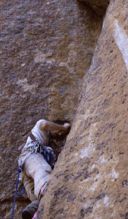
In the Summer of 1975, Chris Puchner and I decided to climb Fred Beckey’s route on Elephants Perch. Day One: we lugged large packs full of big wall climbing gear into the lakes at the base of the wall. To carry both climbing and camping gear, each of us carried two packs lashed together. These masochistic bundles of equipment exceeded 70 pounds each and had been dubbed “Sawtooth Overloads.”
At that point in my life (age 25), I had climbed one Grade V direct aid route: Leaning Tower in Yosemite. My chief background in direct aid was occasional use of it on an otherwise free climb. Chris Puchner had done a small amount of aid climbing, but he was a natural athlete and always game for anything that entailed suffering.
Following what we thought was Fred Beckey’s classic line, we proceeded for 7 slow leads up a suspiciously easy route, just north of the center of Elephants Perch’s massive face. In current terms, we were in the first major-crack system to the north of “The Mountaineer’s Route.” We mostly free climbed but, on our last pitch, Chris ended up doing some direct aid as well. At the end of Lead #7 was a nice, flat 10 x 10 ledge waiting below a slightly overhanging, very thin crack. Since we had brought bivouac gear, Chris and I decided to wait for morning before attacking the wall above.
During the short night, a cloud of mosquitoes raised unseen from the lakes below and, in our sleep, we were both savagely attacked. I remember Chris mocking my puffy face the next morning. However bug bites on a bivy were much better than a thunderstorm–always our major fear in the Sawtooths.
The next morning we discussed our growing certainty that we were on unclimbed terrain. We felt excitement about pioneering a new route, rather than depression at not being on “The Beckey Route.” We always enjoyed doing something different. Thus inspired, but stiff and bug bitten, Chris attacked the aid crack above our ledge. The crack ran vertical about 20 feet to a small overhang, then continued thin, vertical, and unrelenting for a full 150 feet to where the crack finally widened. Chris went up a ways, bitched about not having enough thin pitons and retreated. I accepted his judgment and we rappelled off the route.
In the Summer of 1977, I was back with a secret weapon and a fantasy. The secret weapon was Mike Paine, a very good climber who I suspected would be of great help in climbing Elephants Perch. I had also found more information on Elephants Perch and was certain that instead of repeating the Beckey route, Chris Puchner and I had stumbled upon an actual new route.
The plan was to do the route with Mike and my girlfriend Jennifer Jones, just before my 10th high school reunion in nearby Hailey. Ray Brooks (high school social retard and non-athlete, voted most likely to be a nuclear physicist) would show up for the class reunion having just knocked off a prestigious first ascent in the Sawtooth Range. I would, of course, have my tanned and muscular woman on my tanned, muscular, and hopefully slightly scarred-up arm.
Once again we had to haul a huge load of climbing gear to the base of Elephants Perch. However, we had stashed 3 climbing packs full of food and climbing gear at the entrance to the canyon that goes up steeply to Elephants Perch on another climbing trip into the Sawtooths a few days before.
Unfortunately, when we arrived at the place where I had hidden the packs under bark and vegetation, they were no longer there. Some searching revealed fresh bear scat with aluminum foil in it. A wider search revealed 2 destroyed packs, no food and some climbing gear scattered around. Finally we found the 3rd missing pack over 200 yards away. It had been full of only climbing gear, weighed about 30 pounds and was intact but covered with tooth marks. United with our gear, we were short of food and low on water containers, but had enough equipment to proceed.
Mike Paine and I had been climbing together a lot that Summer. But Jennifer had not climbed at all since she had been off on an archaeological dig in Washington. We humped our “Sawtooth Overloads” up the steep climbers trail from Redfish Lake Creek into Elephants Perch Valley. Then Jennifer and I spent the late afternoon on a short warm-up climb for her.
Jennifer Jones and Mike Paine on Elephants Perch with Mike Paine leading.
Early the next morning we were off and up, burdened with bivouac gear and water for a 2-day climb. Mike and I swapped leads, making rapid progress up the first pitches, which had taken Chris Puchner and me a whole day 2 years before. Early in the day, we unexpectedly found ourselves back on the fine flat bivouac ledge, just below Chris and Ray’s high point of 1975. We had turned the 7 leads into 5 leads with my knowledge of the route and Mike’s willingness to run out the rope. Mike had also free climbed through an area where Chris had resorted to much slower aid climbing. Directly above us in a right facing corner stretched the thin aid crack.
As the direct aid expert or, more correctly, as the only person with much direct aid climbing experience, I got to lead the long, thin, aid crack. I had brought every thin piton and nut available for the aid crack and I used them all. The small overhang was not difficult to aid over but above that the crack stayed unrelentingly thin, accepting only Knife Blades and thin Lost Arrow pitons. It finally started to widen just as I was running out of thin pitons. I must confess that my lack of aid climbing experience and the vertical wall kept me placing aid pitons more closely together than good style dictates. The “clean climbing-throw away your pitons and use nuts for protection” revolution had occurred in the early 1970s. We were fervent users of nuts, when possible. In this crack, however, it was mostly not possible.
Ray on the aid crack, Pitch 6 of the Pacydermial Pleasantries Route.
Somewhere well up the aid crack, I ran so low on thin pitons I was forced to resort to very small wired-nuts (Copperheads) for aid placements. Some of these did not exactly fit well into the skinny crack so I resorted to bashing them into place while nervously humming that old British ditty: “When is a chock a peg?”
One well known fear of aid climbers is the dreaded “zipper” fall: where an aid placement you are standing on fails, then a number of placements below fail when your accelerating falling mass “zips” them out of the crack. I was aware that below me were a bunch of fairly insubstantial nuts and pitons. Of course, one of the nuts I had hammered on popped out of the crack just after I fully committed my weight to it. Thankfully, my “zipper” fall only pulled 2 more pieces of aid out of the crack before the rope stopped me.
I was used to taking lead falls but generally there was nut protection I trusted in cracks below me. Here the little demons inside my head were chuckling loudly about my good chance of taking a huge fall when every thin piton below me zippered. I pushed my fear into action and renewed a controlled struggle back up the crack. At almost the end of the 150-foot rope the crack widened slightly and accepted several large nuts. I felt relatively safe.
WOOHOO! I had a decent semi-hanging belay with even a slight footrest. I had vanquished the thin, vertical aid crack. Mike Paine jumared up the rope to me, shared some water that I was very grateful for and attacked the next lead. Above my belay, the crack was wider and in a much larger right-facing corner. Mike was forced to aid climb up the crack, and suffered considerably. There were 2 problems. First, although Mike was a great free climber, he had done very little direct aid climbing. Second, the suddenly wide crack demanded large nuts which we did not have a copious supply of.
I had convinced myself the worst was over after my lead but Mike’s thrashing and muttering above me indicated otherwise. However, I knew that even if Mike ran out of nuts for the crack, we had brought along “the bolt kit.” This consisted of a ¼-inch drill in a steel holder and a small supply of bolts. When a climber could not find anywhere to place a nut or piton, he could always spend 20 laborious minutes hand-drilling a 1½-inch deep hole by hammering on the drill then pound a special “Rawl” drive-in bolt into place. Although this was accepted technology for rock climbing, it was considered to be “bad form.” In theory and practice, climbers could climb almost anything by “bolting their way up.”
A possible slide into the low morals of using bolts for upward progress was taken out of our hands. During Mike’s struggles, the drill and holder (which had been in his pant’s pocket) worked loose. I heard a melodic “ding, ding, ding” and muttered “oh shit.” The bolt kit came flashing by me. We were now limited to cracks for placing our protection.
After more struggles, Mike finally called down to me that he was giving up on the crack he was in. He wanted me to lower him from a secure nut he had placed at his high point and he would pendulum to another crack about 20 feet to our right. This was a fairly normal maneuver in big-wall climbing. I started lowering Mike back down to my belay point to make the pendulum. However, when he was about 15 feet above me he started rolling his eyes and groaning.
Mike Paine had a mild form of epilepsy from a high school football injury. I had seen him have seizures twice before and the symptoms he was exhibiting now were identical to those starting a seizure. I knew he would instantly be fine if he could take his medication pill, which he always kept handy. I feared he might not be able to access those pills without my help. The consequences could be horrible.
I dropped Mike to my belay quite quickly. At that point, he looked at me with alarm (as he was bouncing up and down) and exclaimed: “Christ, Brooks, what are you doing? The nut I’m dangling from isn’t that solid.” I quietly asked, “You’re not having a seizure?” “No way man,” Mike replied, “The climbing harness was just killing my kidneys.” So with that crises over, Mike was able to run back and forth on vertical rock, supported by the rope, and grab onto the crack 20 or so feet to our right. He scrambled up some lower-angled rock a few feet, put some nuts in for a belay and I thought we were all set to go higher.
The maneuvers I would have to perform to follow Mike’s pendulum were a little complicated and put me at risk of a considerable fall onto Mike’s belay. For that reason, I asked Mike to reassure me that he had a good belay just in case something went wrong. He wouldn’t give me any mental comfort. I just wanted him to tell me it was okay. We proceeded to have a fairly loud discussion on the subject that ended with him shouting: “Christ, Brooks!” “When is a belay ever really good!” At this point, we decided to call it a day and retreat to our bivouac ledge 150 or so feet below.
By this point, Jennifer had been waiting patiently on the bivy ledge for about 6 hours. She had been alarmed by increasingly urgent yells between Mike and me and had, early on, noted the passing of our bolt kit. Somewhere in that long stressful afternoon, she decided it looked a lot like Ray and Mike might well go ding, ding, dinging, down the wall just like the bolt kit. After that epiphany, she prudently untied from the potential mutual suicide pact that she suspected the climb had become. Securely tied to her ledge, but not to us, Jennifer had somewhat tearfully waited for the drama to play out.
I should mention that in a 30-year climbing history, I have only witnessed one other incident where a climbing party member had decided to unrope before a possibly deadly group fall could occur. I was climbing in the Canadian Bugaboos in the mid-1970s with Chris Puchner. We impressed a couple of very competent female climbers with our ice climbing abilities. They subsequently dumped the English lads they were climbing with and went off to the Canadian Rockies to climb with us. Climbing conditions were horrible due to recent heavy snow. In desperation, we ended up doing the tourist route on 11,100-foot Mount Victoria, which had enough fresh snow to make it “very interesting.”
On the descent from the summit of Mount Victoria, I belayed my female climbing companion down a steep, but very snowy, chimney. She exited onto a ledge and vanished from my sight. After a few minutes, she called “On Belay.” I climbed and skidded down the mixture of loose rock and snow in the chimney without ever finding a substantial hold. Several times I believed I was about to fall, but knew the rope to my partner would catch me. After a while, I reached the ledge and walked around a corner to see her tying back into the climbing rope. She looked up and saw me, then quite calmly said: “I couldn’t find any anchors to protect a belay with. Didn’t see any reason to die with you if you fell.” Women are so practical!
Once Mike and Ray rejoined Jennifer safely on the bivouac ledge, all was soon better. A little food and water led to a good night’s sleep. No mosquitoes or thunderstorms arrived during the night and the next morning we woke ready to continue the climb. Mike and I jumared back up to my high point. Mike cleaned the nuts from his pendulum lead, protected by my good belay anchors and then jumared up to his doubtful belay. With more nuts, he was able to improve the anchors and pronounced it “pretty good.” Of course, if we hadn’t dropped the bolt kit, we could have set “bomb-proof” belay anchors with it. I then jumared up to Mike’s belay while Jennifer took up my old belay station as a safety backup.
At that point, Mike took off on the most difficult free-climbing lead of the route. It involved a delicate balance of friction and crack climbing on a very steep slab. Mike thought it was 5.9 and after following the lead with jumars, I was willing to agree. My next lead took me into a huge lower-angled chimney. When I reached the end of the rope, I propped myself into the chimney, placed anchors very carefully and then belayed up my partners. The problem was that the back of the chimney (about 5 feet below my belay) was piled with loose rock. If our climbing ropes disturbed any loose rock, those below me would not have enjoyed the subsequent projectile shower.
As I belayed up Mike and Jennifer, I coiled the rope over my legs to avoid disturbing rocks. Mike led on up, Jennifer went next and, about 1-½ hours after propping myself across the chimney, I could finally move. I immediately discovered a problem. My left leg had gone to sleep. It was numb from the knee down.
After doing all the standard things you do to wake up a numb limb, I gradually accepted I had a problem. The leg worked; I just couldn’t feel anything with it. I climbed up to Mike and Jennifer and informed them I had a slight incapacity. Mike led the final 3 easier leads and we were on top of Elephants Perch at about 1:00PM. We loitered around the summit for a while then decided that, if we were going to make my class reunion party, we had better start down.
The Pacydermial Pleasantries Route is in white. The arrow shows the bivouac ledge. The job to the right with white line indicates the pendulum.
Since my leg still had not awakened, Mike and Jennifer took most of the weight for the climb down. The easiest routes off of Elephants Perch are mostly walking down talus. I soon discovered I had to pay very careful attention to foot placement with my left leg, otherwise it would buckle under my weight. Despite my care, I took a couple of minor falls.
After reaching our camp, we jumped in the lake for a much-needed bath. Cleaner and much revitalized, we set off down the steep trail to Redfish Lake Creek. We had also picked up our backpacks and camping gear and now had more weight. Mike had martyred himself carrying a huge amount of weight, but I had about 50-60 pounds of gear in my Kelty frame backpack. Of course, my leg was still numb. The mile or so down to Redfish Lake Creek is very steep and I had to be very careful. I took more minor falls along the way.
Finally, we hit the creek bottom and some smooth granite slabs for walking surface. In the dim forest light of early evening, I failed to see a small stick that rolled under my right foot. I lost my balance and quickly threw my left foot out to catch myself. My left leg collapsed (it was numb, you remember) and I found myself stumbling faster down an inclined slab with the heavy backpack and gravity forcing my upper body head-first toward the granite.
About 2 inches before I slammed head-first into the granite, the frame extension on my pack hit the slab first. I somersaulted over into a sitting position and screamed: “That’s it!!” I think my bulging eyes nearly touched the rock just before the frame extension hit! I had been acutely aware my skull was about to be shattered like a ripe kumquat!! It was not in my stock of outdoor trivia that a pack frame extension could also function as a “roll bar.”
The pack with “roll bar” that saved my head. The red item is a fishing rod.
There was still a delicate log to walk over Redfish Lake Creek then 2 downhill trail miles to the lake and hopefully a waiting motorboat. After we reached the far end of the lake, we would have had a 65-mile drive to Hailey and the party. We camped right where I had fallen instead. Yes, I gave up on making the class reunion party. They probably would not have been impressed with our smelly bodies and matted hair. I didn’t have any good scars on my arms either.
The next morning, we cleaned up the remains of the picnic the bear had made of the two stashed climbing packs a few days before and had a mellow walk out. My leg recovered in about 6 months. I made it to my 20th class reunion. One disappointment was that we only took one picture the 2nd day of our climb. I have discovered that the number of pictures taken is inversely proportional to the difficulty of the route. Somehow the camera never got much use when I was suffering through an epic. I think it all has to do with priorities. For us, staying alive was more important than taking pictures.
I wrote up the route as “Pacydermial Pleasantries” for the American Alpine Journal. They published the description, but not my cool route name. I indignantly protested: since I had achieved a pinnacle of status in the climbing community with a free charter membership in the DFC&FC as well as a paid membership in the American Alpine Club. My protest was ignored. The rumor mill told me the stuffy AAJ editor only allowed route names that were in Webster’s Dictionary or were proper nouns. “Pacydermial” was not in Webster’s and did not make the cut.
Ray Brooks
Copyright 2003
Below is my heavily edited (by AAJ staff) route description. They even changed my first name from Ray to Raymond.
The 1979 American Alpine Journal route description under “Climbs & Expeditions: Idaho”:
Elephants Perch, Northwest Face, Sawtooth Range. Chris Puchner and I attempted a new route on the Northwest Face of Elephants Perch in 1975 but ran out of thin-crack aid gear. In 1977, Mike Paine, Jennifer Jones and I completed the 11-lead route in 2 days. The route is 150 to 200 feet south of the route Bill March did (A.A.J., 1976, Page 455). Our route went up the right side of a huge flake while he went up the left side of it. Raymond Brooks