Category: Borah

  • The End of the Last Idaho Ice Age By Bob Boyles

    The End of the Last Idaho Ice Age By Bob Boyles

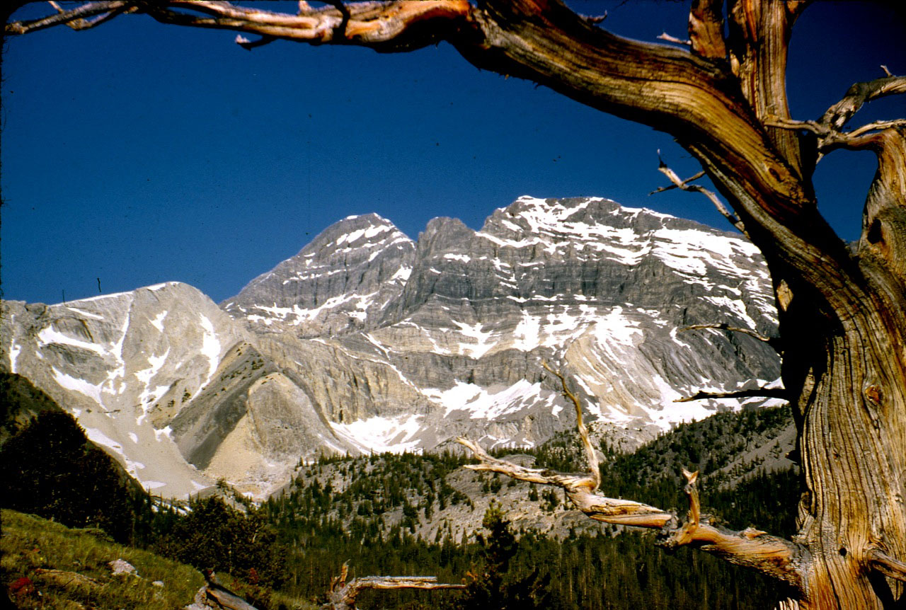
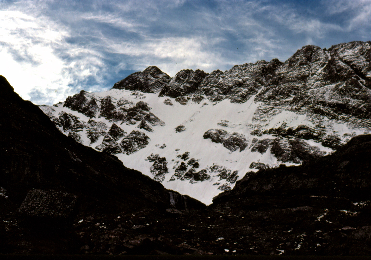
    I first saw the North Face of Mount Borah in the Summer of 1972 while working under contract with the U.S. Forest Service. We were flying helicopters near Horseheaven Pass in the Upper Pahsimeroi Valley, where our daily flights offered unrivaled views of the north and east sides of the Lost River Range. But one face in particular stood out from all the others, and that was the North Face of Mount Borah. Lacking any snow, the face was a dark, steely gray color unlike anything I’d seen in Idaho before. I wasn’t a climber at the time but that was soon to change. I never forgot what I had seen that Summer.

    Two years later (1974), we made a reconnaissance hike into the cirque below the East Face of Mount Borah with the intent to find a climbing route that would lead to the summit. The lower part of the face held what looked like a large snowfield, but upon closer inspection, we found that it was more than just frozen snow. Underneath the snow was hard ice, the kind that only forms from years of accumulation, where the constant pressure slowly squeezes all of the air out of the ice, leaving it vivid blue in color. To a climber, this find was important because ice climbing generally requires specialized gear that one may not carry if expecting to only climb on snow. To the best of my knowledge, no study was ever made of this ice field before it disappeared.

    A year or two later, while attending Boise State University, I heard about Bruce Otto’s discovery of Idaho’s only known glacier on the North Side of Mount Borah. Bruce was a climber and Boise State University geology student who was familiar with Mount Borah and its perennial snowfields. In 1974, while doing research for a class project, he hiked into Borah’s North Face Cirque to study the snowfield and see how much it resembled an actual glacier. What he found in ice was much more than he expected. So the next year he returned with Monte Wilson, his professor and a specialist in the study of glaciers. They would return many times over the next ten years to study the glacier and its annual changes. Bruce’s description of the glacier talks about how it was over 200-feet thick, 1,000-feet wide and 1,200-feet long. He also describes how they determined the glacier was estimated to be 500 or even a few thousand years old. For a relatively short period of time, the glacier was known as the “Otto Glacier.”

    Beginning in 1973, my climbing partners and I embarked on an ice climbing binge, seeking ice wherever we could find it. We found a fair amount of seasonal, winter ice in the canyons of Southern Idaho, but rarely found the hard alpine ice we were craving. The Sawtooths were too low in elevation, and while the nearby Tetons were the most likely place to find alpine ice, we found the range’s ice seasonal and unreliable. While volcanos like Mounts Hood and Rainier had glacial ice, climbing into open-ended crevasses, just to practice, didn’t seem worth the effort for the risk. The Canadian Rockies did have what we were looking for, but were just too far away for poor students to consider. So based on my 1972 aerial observations, and with the knowledge of Bruce and Monte’s discovery, we turned to Mount Borah.

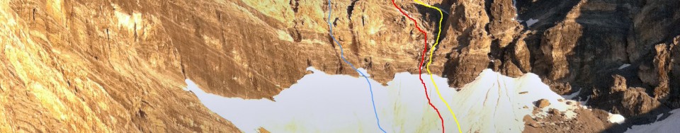
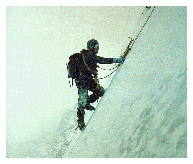
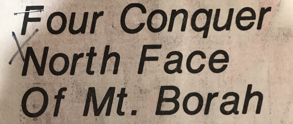
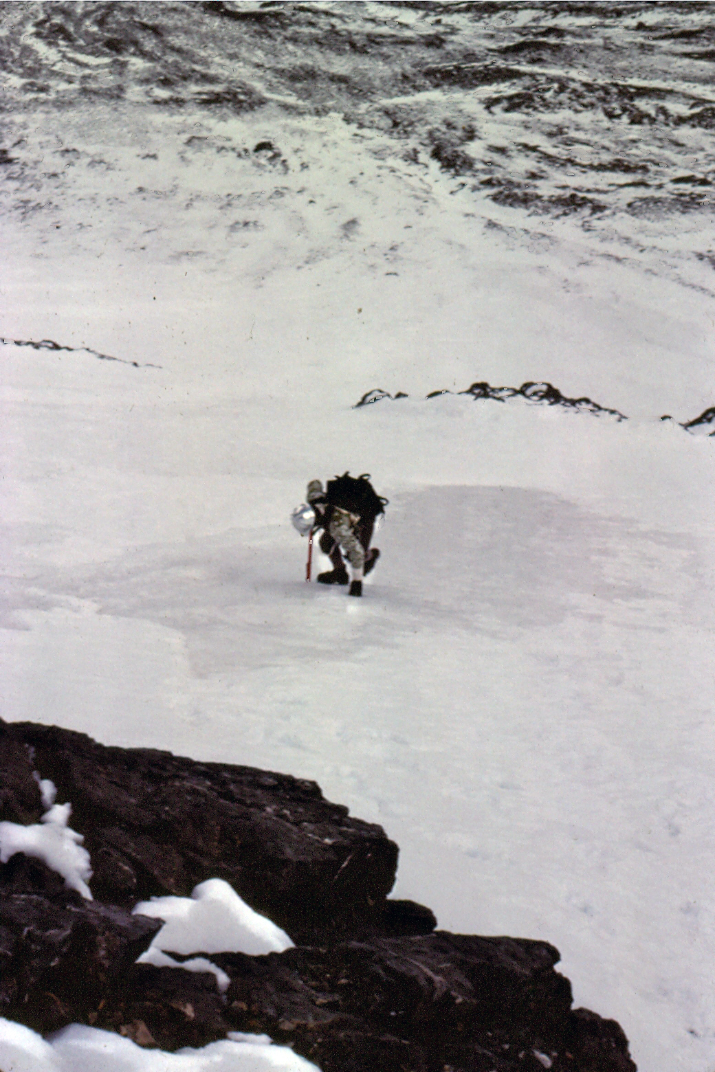
    In September 1976, Frank Florence and I made plans to climb Borah’s North Face, but a torrential thunderstorm turned us back before we reached the moraine below the face. Cloud cover obscured the mountain and all we saw was the lower snowfields, leading us to believe that was all we were going to find on this mountain. In late October, Mike Weber and I returned to give it another go. The weather was perfect this time and after climbing the lower cliff band, we finally got a good look at the North Face. The face was covered with a light dusting of snow from the first snowfall of the season. So until we reached the top of the moraine, we were expecting nothing more than a snow climb. At the top of the moraine, Mike and I geared up, and from the very first swing of our ice tools we knew we had finally found what we had been looking for. The ice was thick and rock hard, not brittle like so much of the Winter ice we had climbed before. We half expected the ice would turn to snow the higher we went but it did not. The ice continued all the way to just below the summit. Like Bruce and his discovery of the glacier, we found more than we ever expected.

    If you look closely, you can see the old blue ice showing in places. Under the snow, the ice appeared to be over 50-feet thick. The East Face of Mount Borah – June 1974. Photo by Bob Boyles
    The East Face of Mount Borah (June 1974). If you look closely, you can see the old blue ice showing in places. Under the snow, the ice appeared to be over 50 feet thick. Bob Boyles Photo
    North Face of Mt Borah - Oct, 1976. Photo by Bob Boyles
    The North Face of Mount Borah (October 1976). Bob Boyles Photo
    Mike Weber showing off his French technique on the lower ice fields of Mt Borah. If you look closely, you can see the old blue ice showing in places.  Bob BoylesBob Boyles photo
    Mike Weber showing off his French technique on the lower ice fields of Mount Borah. If you look closely, you can see the old blue ice showing in places.  Bob Boyles Photo

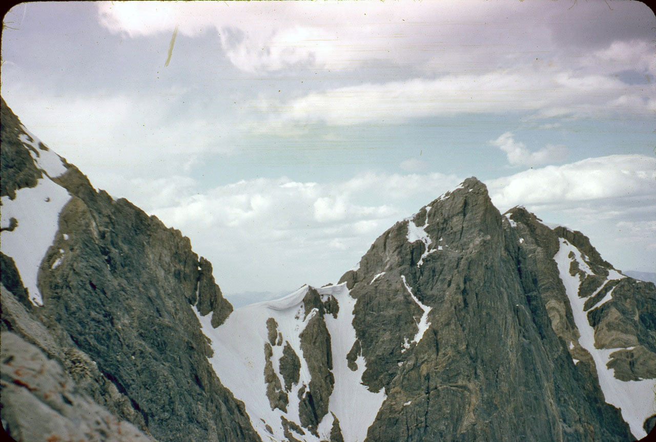
    My partners and I continued to climb the North Face of Mount Borah throughout the 1980s and we just assumed the ice and glacier would always be there. During most of the year, the face was covered with snow but, by the Fall you could count on the underlying ice showing through. On one of our trips in the mid-1980s, we discovered that a massive avalanche had occurred, taking most of the previous Winter’s snowfall with it. Bruce’s snow measuring equipment was wiped out and was carried almost a mile down to where it now sits. Little did we know at the time that we would be part of a small group of climbers who actually got to see, stand, and climb on Idaho’s last, and perhaps only, remaining glacier.

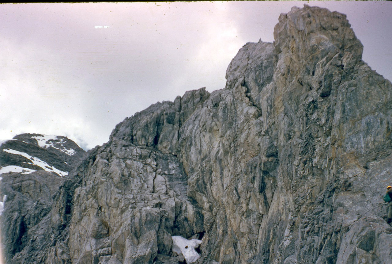
    In September 1990, Mike Weber, Curt Olson, and I returned to the North Face expecting to find conditions similar to what we had found for the previous 14 years. We were quickly disappointed when we got close to the base of the North Face. The lower ice fields and the glacier were, for the most part, gone. There was still some remaining old blue ice left on the upper part of the North Face, but the bottom was mostly bare rock.

    The remains of Bruce and Monte’s snow measuring gauge Sept, 2010 Photo by John Platt
    The remains of Bruce and Monte’s snow-measuring gauge (September 2010). John Platt Photo
    The North Face of Mt Borah Sept, 1990 – Photo by Curt Olson We were in shock when we saw this. The glacier and lower ice fields were almost gone. This was the last photo we got of the old blue ice that was estimated to be over 500 years old or more.
    The North Face of Mount Borah (September 1990). Curt Olson Photo

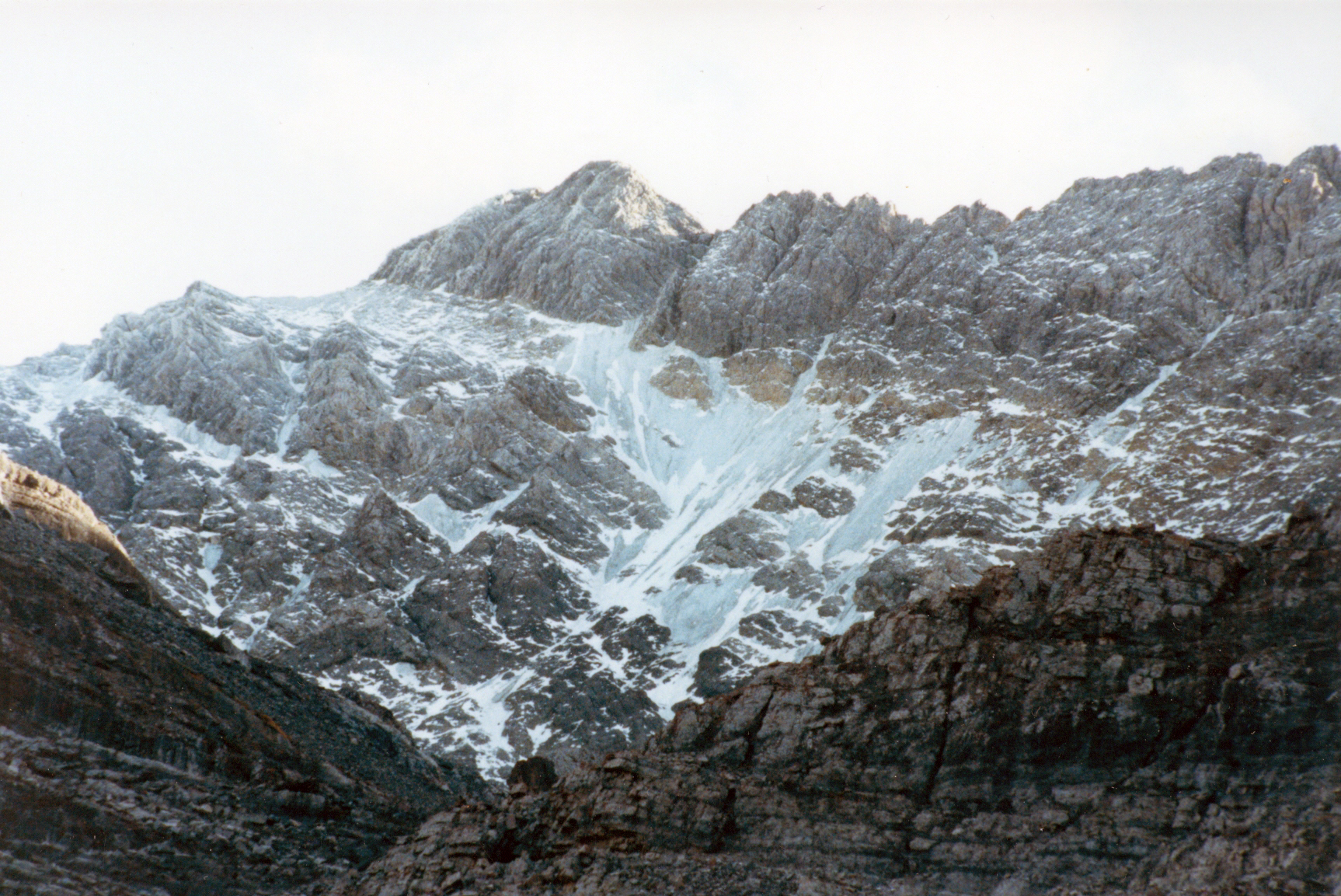
    We were in shock. The glacier and lower ice fields were almost gone. This was the last photo we took of the old blue ice that was estimated to be over 500 years old. In 2009, I was contacted by geologists who were doing a study of the Glaciers of the American West, which included Idaho. As a result of that study, Idaho was found to have no remaining glaciers with the exception of perennial snow fields and a few rock glaciers where all of the ice is underground.

    In 2017, I was disappointed to read a trip report that highlighted the demise of snow and ice on the North Face. This news was especially troubling as the 2016-2017 winter resulted in a solid snowpack existing above 8,000 feet in the central mountains in June. Many high-elevation basins had more than twice the normal snowpack. I don’t know what it would take for the ice to come back short of another ice age.

  • Wayne Boyer

    Wayne Boyer

    Wayne Boyer was a compatriot of Lyman Dye and one of the founders of the EE DA HOW Mountaineers, an Eastern Idaho climbing club. Boyer, along with Dye and Art Barnes, climbed many difficult routes in Eastern Idaho including his first ascent of the East Face of Mount Borah in 1962.

    Wayne Boyer on the first ascent of Borah's east face in 1962. Lyman Dye Collection
    Wayne Boyer on the first ascent of Mount Borah’s East Face in 1962. Lyman Dye Collection
  • Mount Borah: East Face, Dye-Boyer Route by Bob Boyles

    Mount Borah: East Face, Dye-Boyer Route by Bob Boyles

    Note from the Editor: This wonderful article, provided for the Climbing History Section of the website, includes information that can be used to plan an ascent of Mount Borah’s East Face Dye-Boyer Route. As such, we have also included it as part of the Online Borah Climbing Guide.


    Idaho – A Climbing Guide identified a route on the East Face of Mount Borah with a brief description of a climb that had been done in 1962 by Lyman Dye and Wayne Boyer, two pioneers of Idaho mountaineering. It read:

    “East Face (II, 5.2). Climb the face from the notch on the Northeast Ridge (between the summit and Point 12247). Climb to the notch from Rock Creek, which is just to the north. The crux of the climb is the first 90-foot pitch out of the notch. The angle decreases and the holds improve above this pitch. First ascent: L. Dye, W. Boyer in 1962

    For decades, I assumed that Dye and Boyer had gone up Rock Creek (the standard approach to the North Face) to reach Point 12247 and from there climbed the Northeast Ridge to the summit. While the Northeast Ridge does provide a great view of the upper East Face and there is a traverse that cuts across the face, it leads directly to the summit, so I never understood how they could call their route the “East Face.” After reading the above description dozen of times and closely studying a topo, I realized that they must have gone up Rock Creek on the Pahsimeroi (east) side of the range.

    Rock Creek leads to the upper East Face, one drainage north of the East Face Cirque where we had climbed in 2011 and 2012. Everything seemed clear to me now except for one detail and that was how they got to the notch between Point 12247 and the summit.

    Being more than curious at this point, I contacted Tom Lopez to see if he had any more information about this route. Unfortunately he had none, but he did tell me that Lyman was still alive and living in Idaho. Using this lead, I was able to get in contact with Lyman and he most graciously provided me with all of the pictures and information for this route page. He also told me that he last climbed Mount Borah in 2013, at the age of 80, but that would be his last trip due to his doctor’s orders.

    I was greatly honored that Lyman would share this little slice of Idaho’s early mountaineering history and am using his description and photos for the route information. Lyman perfected his discussion of the route with a bit of his early climbing history relating to his pioneering climbs in eastern Idaho and of the EE-DA-HOW Mountaineers. He writes:

    “I started climbing Borah in 1957, done it in Winter and helped with search for Guy Campbell and Vaughn Howard when they went missing after an attempt after Thanksgiving one year. Those were some of the most horrendous conditions I have ever seen on the mountain. Art Barnes and Wayne Boyer were with me on just about all of the climbs in the Little and Big Lost Rivers and the White Clouds. We had a climbing group called the EE-DA-HOW Mountaineers. Wayne, his sons and I were on Mount Borah a year ago (i.e., 2013) in August when I was 80. It had been 57 years ago we climbed it together for the first time. Doctor says no more high elevations for me, sadly enough. We have been on it in almost every condition you can imagine. Winter, Spring, Summer and Fall. Not many areas on the mountain I haven’t been on at least once. When I lived in Arco, Mount Borah or King Mountains were the conditioning climbs when each climbing season began in the Spring.”

    Lyman's sketch showing the Rock Creek approach to the East Face of Mt Borah. Photo - Lyman Dye
    Lyman’s sketch showing the Rock Creek approach to the East Face of Mount Borah. Lyman Dye Photo

    Lyman’s 2014 narrative continues:

    If you will look at the pictures I sent you together as a group, at the very first mailing to you. The first picture had the Mount Borah East Buttress and the ridge coming off to the left. There is an angular ascending snowfield up to the ridge out of the canyon. That is where we gained the ridge crest and dropped over the East Ridge then contoured over to the big lower snowfield at the base of the face.”

     Wayne Boyer Photo/Lyman Dye Collection
    Lyman in profile below the massive East Face Buttress. Wayne Boyer Photo/Lyman Dye Collection

    Lyman’s narrative concludes:

    “If you will look at the second picture in the group of pics I sent you, there is a pic of me in profile near the East Buttress. To the left of my shoulder, you will see two snow fingers protruding upward to the right like tepees. The second one of those has a small snow patch up in the couloir above and to the right. We went up the rock face above that little patch, in and out of the crack, on the left side up to the thin snow finger, that ascends upward to the right, at the head of the finger to the right. At that point, we left the snow and climbed up the cliff formation past the black rock outcropping to the upper snow field.

    There are two exit cracks that go up to the Northeast Ridge about halfway across the snowfield. I weighed taking one of those to the summit ridge but we had been out on that face for around three hours and we decided to go to the saddle and relax for a few minutes and have something to eat. I looked over the cliff formation and didn’t think it looked all that bad, and I put all my hardware in my pack and started up the cliff. I got about 40 feet up and got hung up under a little shelf. I could feel a crack with the tips of my fingers and would like to have had a piton or something to jam down in it for leverage, but everything was tucked away in my pack. I thought about down climbing and trying a different angle but didn’t like that feeling either. My legs were doing the piano dance by this time and so I figured I was probably going to peal out of there and fall or make a lunge for the crack and go for it.”

    “The rest of the way to the summit was uneventful, a breeze so to speak. We dropped off the summit to the south to the first notch, and then set up rappels to get back down off the face. If I had paid more attention to the picture of me with the buttress, I would have seen the route sooner I think. The snow in your picture of the face (2012) is not anywhere as definitive as it is in the second picture. We had bigger snowfields when we did it than when you were up there.”

    Lyman provided these additional photos taken during the first ascent of the Dye-Boyer Route on the East Face.

    Wayne Boyer climbing on the East Face. Photo - Lyman Dye
    Wayne Boyer climbing up the East Face. Lyman Dye Photo
    Wayne Boyer coming up over a ledge on the lower East Face. Photo - Lyman Dye
    Wayne Boyer coming up over a ledge on the lower East Face. Lyman Dye Photo
    Looking up the route. Wayne Boyer is barely visible on the right side of this photo. Photo - Lyman Dye
    Looking up the route. Wayne Boyer is barely visible on the right side of this photo. Lyman Dye Photo
    Looking up at the Northeast ridge and summit block (far left). Photo - Lyman Dye
    Looking up at the Northeast Ridge and summit block (far left). Lyman Dye Photo
    Looking down the col into the East Face cirque. This is where the East Face route joins the Northeast ridge. Photo - Lyman Dye
    Looking down the col into the East Face Cirque. This is where the East Face Route joins the Northeast Ridge. Lyman Dye Photo
    Lyman Dye climbing on the East Face of Mount Borah. Photo - Wayne Boyer. Lyman Dye Collection
    Lyman Dye climbing up the East Face of Mount Borah. Wayne Boyer Photo. Lyman Dye Collection
    Looking up at the Northeast ridge and summit block (far left). Photo - Lyman Dye
    Looking up at the Northeast Ridge and summit block (far left). Lyman Dye Photo
    Wayne and Lyman with the col and Northeast ridge in the background. Photo - Lyman Dye
    Wayne and Lyman with the col and Northeast Ridge in the background. Lyman Dye Photo
    Looking across the East Face (left-to-right) at the Northeast ridge, the col and what we call the "Super Buttress." Photo - Lyman Dye
    Looking across the East Face (left-to-right) at the Northeast Ridge, the col and what we call the “Super Buttress.” Lyman Dye Photo
    Lyman and Wayne on the summit of Mount Borah. Lyman Dye Collection
    Lyman and Wayne on the summit of Mount Borah. Lyman Dye Collection
    Wayne and Lyman on the 90-foot crux of the Northeast ridge. Photo - Lyman Dye
    Wayne and Lyman on the 90-foot crux of the Northeast Ridge. Lyman Dye Photo
    Wayne looking into the East Face cirque from the summit of Mount Borah. Photo - Lyman Dye
    Wayne looking into the East Face Cirque from the summit of Mount Borah. Lyman Dye Photo
    Rappelling down the East Face of Mount Borah. Photo - Lyman Dye
    Rappelling down the East Face of Mount Borah. Lyman Dye Photo
    Looking across the East Face (left-to-right) at the Northeast ridge, the col and what we call the "Super Buttress." Photo - Lyman Dye
    Looking across the East Face (left-to-right) at the Northeast Ridge, the col and what we call the “Super Buttress.” Lyman Dye Photo
    Wayne and Lyman at one of the East Face tarns. Photo - Lyman Dye
    Wayne and Lyman at one of the East Face tarns. Lyman Dye Photo
    A small tarn at the bottom of the East Face cirque. Photo - Lyman Dye
    A small tarn at the bottom of the East Face Cirque. Lyman Dye Photo

    Return to the Main Mount Borah Page. 

  • 1977 Borah North Face Winter First Ascent

    1977 Borah North Face Winter First Ascent

    Bob Boyles, Mike Weber, Art Troutner and Frank Florence made the first Winter ascent of Borah’s North Face. Below you will find one of the few photos they took during the 16.5 hours they climbed and photocopies of 2 Idaho Statesman articles published at the time. Below you will find reminiscences of the climb from Bob Boyles and 3 Idaho Statesman articles which covered the climb.

    Bob Boyles offered these details:

    We climbed the North Face on January 8-9, 1977. The only reason we even considered doing the face in Winter was the drought of 1976-1977. The Winter started out very cold and dry, and it had only snowed a couple of times before we went. So we rolled the dice and hoped the face wouldn’t be loaded up and, luckily, it wasn’t. We got into waist-deep unconsolidated sugar snow on our descent, but it went all the way down to the rocks below and wouldn’t slide. It was weird because when you walked through it, it would push the snow 10-20 feet in front of you.

    When asked about avalanche danger Bob pointed out that:

    The North Face of Mount Borah has only been climbed two times in Winter to my knowledge and both were in 1977, two weeks apart. We did it first and another team from Ketchum (or maybe it was Idaho Falls) did it two weeks later after the cold spell passed. It never got cold again all that Winter.

    What made the climb possible was the drought of 1976-77. During a normal Winter, the cirque would be a pretty risky place to climb. A couple of years after our Winter ascent, we went up in late September and, over a mile from the face, ran into the avalanche debris that carried Bruce Otto’s snow measuring equipment out of the cirque.

    When we got over the cliff band and got a close look at the face, we could see that the whole thing had slabbed off leaving behind a 6-foot crown. The bivy site where we usually stayed was covered in maybe 30 feet of rubble. Realizing that more of the slab might come off, we hugged the left side of the moraine and did a different route far to the left of the face.

    Curt and I did the North Face Direct the next year and the crown was still there presenting a short, vertical step that we had to climbed over. A few years later, another one came down the gully that crosses the main trail to Chicken-Out Ridge. Most people walk right through it without realizing what it is. That slide snapped 4-foot trees like toothpicks and ran at least a mile.

    Bob pointed out the 1977 conditions were an extremely rare occurrence:

    I fish for salmon and monitor the USGS Idaho streamflow site daily during the season. From USGS records, most of the all-time low streamflow rates for Idaho rivers were set in 1977. Those kind of conditions don’t happen very often and we knew it before we went for the North Face. We figured we’d get snowed out before we could get a climb in that Winter. If we had waited one more week the temperatures warmed (for the rest of the Winter) and we would have missed the arctic air mass that had set in. But…no one expected we’d see that kind of drought, and the face could have safely been climbed all Winter.

    Bob also warns that “In a normal Winter, like we’re seeing this year, I would not go up on the face. One might be able to make it up the far left side of the cirque to gain the ridge, but that would bypass the entire face.”

     Bob Boyles supplied this photo, the only photo his team took on their winter ascent of the NF in January 1977. Frank Florence Photo
    Bob Boyles supplied this photo, the only photo his team took on their Winter ascent of the North Face in January 1977. Frank Florence Photo

    The first article discussed the upcoming attempt.

    Idaho Statesman Article
    Idaho Statesman Article


    The second article covered was an announcement that the climbers had succeeded. My copy was not in good enough shape to photograph so it is transcribed here:

    By TOM GROTE

    The Idaho Statesman 

    Four Boiseans Saturday successfully reached the summit of Mt. Borah, Idaho’s tallest mountain, the father of one the climbers said. Lou Florence, president of Sawtooth Mountaineering, said his son Frank Florence, Bob Boyles, Art Troutner and Mike Weber completed the climb in the dark about 5:30AM [Editor’s note: The original article listed the climbers addresses.]

    The climb was completed a day earlier than planned, Florence said, because the four did not have to ski part of the way to the mountain. “The wind had blown away the snow and they took  advantage of the good weather,” he said. Three of the 4 weathered in good condition. Boyles suffered frostbite on 3 fingers. “We won’t know how bad until we see them,” Florence said.   

    The climb to the top of the 12,622 foot summit was believed to be the first Winter ascent along Mt. Borah’s North Face. The climb began about 1:30AM Friday, Florence said his son told him during a telephone call from Arco after the climb. “They ran into a snowstorm a few hours after they started, but the weather then cleared,” he said. Two hours into the climb, the party ran into winds of 20-30 miles per hour, adding a significant chill to the 15-degree temperature, he said. All 4 climbers made the summit after. 28 straight hours of climbing, twice as long as expected.  

    The climbers did not stay long at the top and left no mementos, Florence said. “They were very elated when they reached the top,” he said, “but the bad weather forced  them to a take another way down than they had planned.” The four ate snacks during the climb. They were driving toward Boise late Saturday and were expected back around midnight, he said.  

    The usual Winter route to the summit ridge is on the Southwest Face, Florence said. Although the climbers were taking the more difficult route, they did not have the worst conditions possible. Deeper snow and colder temperatures hamper climbers in February and March, but a January ascent still qualifies as a Winter climb, Florence said. All four are experienced climbers, but only Frank Florence had prior experience on Mount Borah. In January 1973, he reached the top but lost the tips of 3 toes to frostbite. Another group tried to climb the mountain in July, but was forced down by winds up to 55 miles per hour.

    The third article sums up the expedition.

    Idaho Statesman Article
    Idaho Statesman article
  • Photos from the 1976 first ascent of the Direct North Face of Borah

    Photos from the 1976 first ascent of the Direct North Face of Borah

    Below you will find Bob Boyles’ favorite photos from the first ascent of the Direct North Face of Borah (October 1976). The North Face of Mount Borah is considered by some to be one of the finest alpine climbs in Idaho and one of the few faces that holds ice during most years. The lower face starts at around 45 degrees and steepens to around 55 degrees below the summit pyramid. This route takes the left branch of the main couloir until it ends at the short steep rock step (Class 5.7) and then follows low Class 5, Class 4, and Class 3 steps directly to the summit. In the early season (late Spring and Summer), this route is usually a steep snow climb. In late season (late Summer and early Fall), this route can be all hard alpine ice (10 pitches, WI3). In good conditions, this route can be climbed in a few hours. In poor conditions, this route can take all day. The Southwest (Chicken-Out) Ridge is often used for descent.

    Borah North Face Direct. Bob Boyles Photo
    Mount Borah’s North Face Direct Route. Bob Boyles Photo
    NFace0003
    Mike Weber “frenching up” on hard ice.
    NFace0005
    Bob Boyles high on the North Face.
    NFace0007
    Mike Weber at the start of the main couloir.
    NFace0009
    Mike Weber on belay below the crux pitch.
    NFace0011
    Bob Boyles topping out on the North Face Direct Route.
    NFace0012
    Mike on the summit of Mount Borah.
    NFace0013
    Bob on the summit of Mount Borah.