Category: Fatalities

  • Lightning Strike on Borah 1954

    Lightning Strike on Borah 1954

    The Idaho Statesman reported this accident in its September 3, 1954 edition.


    Lightning Hits Climbers

    MACKAY, A lightining bolt struck a mountain climbing party near the top of 12,655 foot Mt. Borah Thursday iatternoon, causing the disappearance of one man and temporarily paralyzing another. A third escaped unhurt. Missing is John Landenberger, 18, son or J. C.Landenberger, superintendent or the Utah division the Kennecott Copper company, Salt Lake City. Robert A. Je‘ster, 20, of Salt Lake‘ City, who later recovered the use of his limbs, was helped to the valley floor by the third member or. the party, Greorge  Pierce, 28, of Trenton, N.J. Pierce told officials here that the party had reached the top of the peak and was starting down when the storm hit; They attempted to slide down one of the snow fields on, the mountain to escape the storm, when the lightning bolt struck.  In the following confusion Jester and Pierce lost track or Landenberger. Pierce told officers that he made a hurried search of the area near him trying to find the lost climber but couldn’t. He then packed the injured Jester to the base or the mountain and to the Fulton ranch 20 miles north or there on U. S. highway 93.  Jester’s only injuries were a. few cuts and bruises from the descent and a burned toe.  A party of searchers was organized Thursday night and began searching for the‘ missing Landenberger. Friday an additional party will make the ascent, lead by Custer County Sheriff Lee Clark Blaine County Sheriff Les Outz and two experienced Sun Valley climbers. The three victims were employed at Sun Valley.

  • 1975 Fatality on El Capitan

    1975 Fatality on El Capitan

    [Editor’s note: This August 6, 1975 article by UPI was published in the Idaho Statesman. No other details are known.]


    Climber, 24, Dies After 70-Foot Fall

    United Press International

    -A mountain climber from North Carolina died in a Boise hospital Tuesday from injuries he suffered in a fall Sunday on El Capitan in the Sawtooth Wilderness.

    A hospital spokesman said Tom Brothers, 24, of Morganton, North Carolina died at 7:40AM from massive injuries. Brothers fell 70 feet while climbing El Capitan. He was about three quarters of the way to the summit when he grabbed rocks that broke loose. His partner, Neil Harrison of Atlanta, Georgia was not injured.

    Brothers was taken to the Sun Valley Hospital for emergency treatment and was transferred by ambulance to Boise. He was the son of Mr. and Mrs. Grayson Brothers of Morganton. Arrangements for cremation were handled by Alden-Waggoner Funeral Chapel in Boise. The family planned an interment on the slopes of El Capitan.

    UPI article 8/6/1975
    UPI article 8/6/1975
  • 1987 Death on Borah

    1987 Death on Borah

    In 1987, an experienced climber descending Mount Borah fell on the snowpack and lost control of his self-arrest. He landed just above a water chute/water-melt tunnel as the avalanche he triggered pushed him into the chute and buried him.

    Water Chutes/Water-Melt Tunnels

    When temperatures warm, water melts below the snow surface and flows in river-like patterns downhill. As the water flows, a tunnel of air forms and melts the snow from underneath. On steep slopes, and in areas with deep gullies, larger chutes/tunnels may form. Much like a crevasse, these chutes/tunnels may not be evident on the snow surface, though sometimes the snow appears thinner or is of a different color. You may also hear water flowing underneath as you near a chute/tunnel area. Like a crevasse, if the tunnel is large enough, a climber can fall through the weakened snow surface and be buried and/or swept by the water under the snow down the tunnel. A fall into the tunnel on a steep slope can also precipitate backfill of snow from above into the tunnel as the melting, weakened snow surface moves to stabilize itself.

    Water-melt tunnels can be large permanent features below established glaciers and year-round snowfields, or short-lived, more shallow features on seasonal snowfields. Accidents and fatalities from falling into water-melt chutes/tunnels are rare, though these melt features are common. However, risk a chute/tunnel posses to a climber is related to a multitude of factors including: the steepness of the slope, the thickness of the snowpack, the terrain below the snow, the amount of melting occurring, whether a tunnel already exists or is forming, and if a chute/tunnel is large enough and close enough to the surface to collapse and fall into.

    An important lesson from this unfortunate accident is that water-melt chutes/tunnels are features that may exist under the snowpack. Take this possibility into account when choosing a descent path and when searching for a missing team member.

    Here are links to a few photos of chutes/tunnels from places outside of Idaho that gives you an idea of what the feature looks like to help you assess this risk on your climbs.

    The accident report was published by the American Alpine Club (AAC) in Accidents in North American Mountaineering, 1988. Read the full article below, or click on the title to read it on the AAC website.


    FALL ON SNOW, LOSS OF CONTROL—VOLUNTARY GLISSADE, AVALANCHE, INADEQUATE EQUIPMENT, WEATHER

    Idaho, Mount Borah

    On June 13, 1987, David Probst (38), who was a member of the Idaho Mountain Search and Rescue Unit for several years, was descending Mount Borah (3,950 meters) with three friends when he fell 150 meters to his death.

    Accident

    They had started late in the morning, around 0900. Knowing there was very little snow, they carried only one ice ax with them. They reached the summit at 1800. Then they started down and, when they reached the saddle between the summit and false summit, they changed to the Rock Creek descent. The first two, Linda Claiborne (30) and Ben Childlaw (35) with the ice ax, started ahead of Probst and Jennifer Smith (31). Probst used a rock as a dagger for control on the snow while Smith waited in the rocks above. Probst lost control while trying to self-arrest. He disappeared around a bend in the snowfield.

    At this time Claiborne and Childlaw were down at the fourth snowfield. They saw a large mass of snow coming down the chute, but no sign of anyone. They climbed back up to Smith. At this point they searched for Probst and, finding his hat at the second snowfield, they started probing for him. They also probed the first snowfield but stopped when it got too dark to work. They spent ten hours climbing down and hiking out for help.

    The local sheriff’s rescue group from Mackay responded but were initially not able to get to the victim’s location because they had no experience or equipment. The 3-person team arrived wearing tennis shoes and jeans, carrying one rope and a carton of Pepsi-Cola. A deputy accompanied them. Idaho Mountain Rescue personnel were on hand at the staging area. The sheriff indicated that he would have his team go up the mountain and assess the situation first to see what resources were needed. As night neared, the sheriff got a MAST helicopter to drop sleeping bags and food for his team. The helicopter flew to 4700 meters and dropped the supplies. The supplies were well scattered after their 1250 meter descent.

    On June 15, an electrical storm hit, and the sheriff ordered everyone off the mountain, suspending the search until later in the week. The sheriff’s team and Idaho Mountain Rescue returned on June 19. The next day, June 20, rescue teams fine-probed the first snowfield. Course probes and tunnels were dug on the second field. An avalanche dog was used but alerted many times on the snowfields. When teams started searching snowfield three, the body was spotted under the snow above a water chute which Probst had slid into with the loose snow. [Sources: various newspaper reports; Larry Novak and Bob Meridith of Idaho Mountain Search and Rescue; and Merle King]

    Analysis

    The late start, an apparently festive group with an experienced leader, and a clear day that deteriorated late in the afternoon led to the circumstances that turned this situation around. Choosing a technical descent route without having adequate equipment put the group at risk. That Probst used a rock for an ice dagger for self-arrest aid indicates the level of concern he had.

    While it seems likely that Probst died quickly, the rescue response was apparently not handled properly. If the victim had survived the fall, he most likely would have died by the time he was finally reached. Technical rescue resources were available but do not appear to have been used appropriately. [Source: J. Williamson]

  • Death on the Way to Mount Church

    Death on the Way to Mount Church

    Editor’s Note: On August 4, 2006, a fatality occurred on a summit attempt of Mount Church. What follows is the final article, published by the American Alpine Club in Accidents in North American Mountaineering 2006.

    I wrote the article along with Butte County Sheriff Wes Collins, with additional input provided by Portneuf Life Flight Registered Nurse Lance Taysom. Wes, an exceptional climber, led the rescue and recovery activities.

    Accidents In North American Mountaineering started as a report from the Safety Committee of the American Alpine Club. The Safety Committee was established in 1947 in response to “the startling increase in the number of mountaineering accidents which occurred” during that particular Summer. The Safety Committee is charged “to investigate climbing accidents and to formulate a program of prevention for the future.” The Committee gathers data “with no intent to criticize persons involved, but rather to learn why these accidents occurred and to emphasize the lessons to be learned from them.” As such, climbers are referred to by their initials and not their names.

    The full article is a thorough accounting and analysis of the events that lead to this tragic fatality. Consequently, the article also provides valuable route information and lessons learned for this increasingly popular peak. You may also click on the title to read the article directly from the American Alpine Club site.


    Fall on Rock, Off Route, Failure to Turn Back, Party Separated, Inexperience, Inadequate Equipment, Idaho, Lost River Range, Mount Church

    Idaho, Lost River Range, Mount Church

    On August 4, I.C. (41) and B.B. (36) set out to climb the standard route on Mount Church (12,200 feet) in the Lost River Range.

    The approach to Mount Church begins with a strenuous 1.5 miles, 1,000-foot climb through the forested bottom of the Jones Creek Canyon. The route then climbs a side canyon for 1,400 feet to a ridge which divides Jones Creek from an unnamed drainage to the west. The bottom is blocked repeatedly by the meandering Jones Creek, which zigzags back and forth leaving steeply cut banks covered with tangled brush and downed timber. The approach route is so difficult that it takes most climbing groups more than two hours to reach the point where the route leaves the canyon bottom. On the day of the accident, there were no other climbers on the route.

    About halfway through the Jones Creek bottom, the climbers left the route and started to climb a steep side canyon. It appears that at first, they believed they already crossed the entire Jones Creek section of the approach and were on the route. After climbing roughly 800 feet, they realized their mistake and attempted to regain the route by climbing north through a large Class 5 cliff band. I.C. was climbing above B.B. and moving over a rock wall that took her out of his view. I.C. told B.B. “Don’t climb that. That was stupid.” She directed him to climb back to the base of the cliffs while she looked for a route down the other side of the obstacle she just climbed.

    B.B. started down but got stuck on a ledge. As he was looking for a route he heard I.C. call his name. Moments later, he heard rocks falling from I.C.’s direction. He also spotted contents from her pack falling down the face and then saw her falling, ricocheting off a ledge and then continuing to fall out of his view.

    At 11:12AM, B.B. called 911 on his cell phone, reported the accident and advised that he was stuck on a ledge. Custer/Butte County Search and Rescue Team and Portneuf Life Flight responded to the scene. Shortly after 12:00PM, as the rescue team was approaching the mouth of Jones Creek, the rescuers witnessed a violent thunderstorm and saw several bolts of lightning strike the upper slopes of Mount Church and nearby Donaldson Peak. The upper part of the route was covered with a layer of hail. Most of the lightning strikes were above the accident scene. After reaching the scene, the rescuers confirmed I.C. had died in the fall. Her injuries consisted of a broken neck and severe head injuries. The rescue team performed a roped rescue for B.B and then walked him out to his truck.

    About 2:00PM, during the rescue of B.B, the team experienced another series of less-intense thunderstorms. During the rescue and subsequent investigation, rockfall was a continual hazard facing the rescuers. Rain from that system produced slippery conditions in the canyon that ultimately caused two rescuers to slip and sustain injuries as they hauled out I.C.’s body.

    Analysis

    Mount Church is one of nine 12,000-foot summits in Idaho. In recent years, climbing all of these peaks has become a popular pursuit for Idaho climbers. The Lost River Range is rugged, steep and wild. Other than Mount Borah, Idaho’s highest summit, the summits in the range are approached cross-country through difficult, debris-filled, cliff-lined canyons.

    The climbers had a topo map and route description from a hiking guidebook. I.C. was a novice climber who had started sport climbing in the spring of 2006. Two weeks prior to the accident, she successfully climbed the busy standard route (mostly trail) on Mount Borah. Her partner was an avid hiker but did not have any climbing experience.

    This accident occurred due to a combination of the inexperience of both climbers and the difficulty of the terrain. Mount Church is not a peak which can be safely climbed by inexperienced climbers. Jones Creek is extremely wild and unforgiving and the bottom of Jones Creek constantly changes from year to year. Ascending the canyon requires physical conditioning, endurance, prior off-trail hiking experience, mental toughness, and map-reading skills.

    The canyon walls are steep and are crowned by broken cliffs. Experienced climbers who would have known from reviewing the topographic map and scouting the route from the valley floor that there were no non-technical routes up the West Side of the canyon. Despite the technical nature of the canyon walls, the climbers left the canyon at the 8,200-foot contour and climbed up the wall to roughly 8,900 feet. As they ascended the slope, they crossed steep, cliffy terrain and a face that steepened as they continued their ascent. The unsuitability of the canyon wall for inexperienced, unequipped climbers is highlighted by the fact that when I.C. fell, she dropped more than 150 feet, bounced off at least 3 wide ledges, landed on a talus slope, and then rolled to a stop some 80 feet below the bottom of the cliff.

    Inexperience also played into the decision to leave the route. Although B.B. was unsure of why they prematurely left Jones Creek, it was likely due to the difficulty of the terrain, that they believed they had actually reached the correct turning point. In reality, they had traveled less than a mile, underestimating the time it takes to cross such inhospitable country. It is also possible B.B. and I.C. left the route in an attempt to avoid the strain of climbing through the obstacles littering the Jones Creek bottom.

    Inexperience was also demonstrated by their decision to continue onto technical terrain without adequate climbing equipment. While technical climbing equipment was not necessary for the Standard Route, the climbers did not recognize the need for such equipment when they ventured out onto the cliff band.

    The climbers got off to a late (8:00AM) departure on a day when the weather forecast called for thundershowers. The early development of thundershowers made the climb unwise, as the majority of the route crosses exposed ridges and faces. B.B. did not mention that weather concerns factored into their decisions. Finally, their decision-making process was simply to react to obstacles by changing directions. They had several opportunities to retreat but did not consider this option until they were in serious trouble.

  • 1948 Idaho Statesman Article: Here’s a Club for You to Join But It’s A Rough Organization

    1948 Idaho Statesman Article: Here’s a Club for You to Join But It’s A Rough Organization

    [Editor’s Note: This September 13, 1948 article was referenced on Page 18 of the book in the Mountaineering History Section. The name “Thatuna Hills” appears in the article. This name, which was not adopted by later map makers, refers to a western extension of the Bitterroot Mountains that now is considered the Northern Clearwater Mountains.]

    THE LION OF IDAHO, Mt. Borah, highest mountain in the state, is a favorite of Gem state mountain climbers. Rising 12,655 feet, the granite crag is often cloud-draped. Mt. Borah is part of the Pahsimeroi Mountains, and is in Custer county in the Lemhi National Forest. The photograph was taken from the Statesman’s airplane, Early Bird Number Four. Inset left shows pole at summit of Borah on Aug. 18 with three-inch layer of rime deposited by cool moisture-bearing wind. Temperature in mid summer rises but little above freezing. Right inset: looking down the other side of Mt. Borah discloses a desolate, rugged, rocky and lifeless mass of granite. Dotted arrow shows route used by several groups of mountain climbers in reaching the summit of Idaho’s highest peak.
    THE LION OF IDAHO, Mount Borah (the highest mountain in the state), is a favorite of Gem state mountain climbers. Rising 12,655 feet, the granite crag is often cloud-draped. Mount Borah is part of the Pahsimeroi Mountains and is in Custer County in the Lemhi National Forest. The photograph was taken from the Statesman’s airplane, Early Bird Number Four. Inset left shows a pole on the summit of Borah on August 18th with a 3-inch layer of rime deposited by cool, moisture-bearing wind. The temperature in mid-Summer rises but little above freezing. Right inset: looking down the other side of Mount Borah discloses a desolate, rugged, rocky and lifeless mass of granite. The dotted arrow shows the route used by several groups of mountain climbers in reaching the summit of Idaho’s highest peak.

    By Jack Anderson 

    Wanna join a club? There’s an exclusive organization which will almost guarantee less than 100 members by 1960. All you have to do to join is climb to the top of a little heap of granite in the middle of Idaho’s rugged area and sign the register atop Castle Peak. There won’t be many names, probably less than 10, on the register. Why climb a mountain? This question is asked to only a handful of Idaho residents, who each Summer go stomping up and down rocky peaks in the Gem state, much to the bewilderment of the majority of inhabitants.

    As an old saw goes, “You don’t have to be crazy, but . . .” Mountain climbers can probably advance a multitude of reasons for their breath-taking hobby. Adventure, danger, artistic ideals, exercise, attainment of skill–all could be bona fide reasons for notching one’s way up and down steep rocky hills. In no state of the union does such a minority group have as vast a field to pursue their reckless hobby. Idaho from the play slopes of its Panhandle to the craggy juts of the Southeast is a series of mountain ranges interspersed with valleys and streams. 

    In the north, the Cabinet Mountains form a purple backdrop for play and fishing on mountain lakes. The Coeur d’Alenes, the Beaverhead Mountains and the Bitterroot Mountains form the eastern boundaries. The Bear River Range, the Blackfoot Range, the Little Lost River Range, the Pahsimeroi Mountains, the Salmon River Range, the Seven Devils, the Thatuna Hills and the Sawtooths round out the mountain fastness.

    The Sawtooths are known as the “American Alps” and aside from evoking “oohs” and “ahs” from tourists, provide the mountain climber with considerable territory. Many of the Sawtooths have never seen the shoe of man atop their snow-locked peaks. In the heart of the Sawtooths, the country is upended. From the summit of Mount Hyndman, a portion of weird country known as the “Devil’s Bedstead” may be seen. Jagged quartz obelisks, jumbled, crumbled, interlaced, present a foreboding warning to travelers. It looks as if Nature took the remnants of orderly creation and threw them in a heap. 

    Who climbs mountains? Many perhaps seriously believe that only escapees from mental institutions would consider climbing to the top of a granite spire and then turning right around and inching back to terra firma level.

    Strangely enough, almost anyone can do it and all occupations have contributed to the ranks of intrepid mountain conquerors in Idaho. A well-known priest has climbed some of Idaho’s roughest pinnacles and several bold damsels have journeyed up lesser peaks.

    Mountaineering, as seen in the movies, consists of dangling out over space, supported by a thin strand of nylon, vainly swiping at a nearby rock with a pick axe. Actually, much fine climbing can be done with little more than a pair of tennis shoes, stout wind, and a determination to get to the top. 

    The lion of Idaho, Mount Borah (12,688 feet up to the topmost point), is a stern-looking, starkly impressive crag of grey granite. It rises in insular majesty from the sage-dotted plains of the Little Lost River Valley. Yet it can be climbed in a day with no more equipment than good tennis shoes, warm clothes and a camera for proof. The azure-scraping rocky peak is often cloud-draped and subject to squallish Summer storms and lashing lightning. On a clear day, Borah is a full day’s work but climbable.

    In the early days, Mount Hyndman (near Hailey) was considered by settlers to be the highest hill in the state. Recent topographical measurements give Borah the edge by about 150 feet. Hyndman is another boot hill or even a tennis shoe Teton for the average man. However, it is a rough 10-mile walk from car to summit, and vice versa, so most leisurely hill toppers take it as an overnighter. Boulder Mountain, Silver Peak, and Mount McCaleb are all climbs for the amateur with no fancy equipment.

    Farther into the canyons (where somber shadows live) rise mountains which have given some of the yodeling Swiss a few bad moments, and caused many to go home empty-sighted of mountain-top views. The Finger of Fate, a needle-like point of non-imposing  altitude, baffled a Boston, Massachusetts mountain climbing couple for an entire Summer. They finally gave up and went home to write a book about Idaho mountains. Many of the Alp-type mountains (termed “horn” mountains) have  precipitous sides which can be traversed only by “graveling.” Using ropes, spiked shoes and pitons is required on many Idaho mountains.   

    What’s up there? At the top pf some mountains will be found a pole and a stout iron box. Inside the water-proof container will be a register which the successful sign for posterity and relate the travails of their upward journey. An occasional hawk screams at the violation of his solitude. Trees show the battle with the elements and often have the bark shorn off the windward side from the battering of hailstones and buffeting gales. Lightning scars, snow slides and other examples of nature’s violence in the eons of chipping down the mountains are to be seen.  

    Caution is the watchword in mountain climbing and the violator seldom gets another chance. An experienced woman climber fell from the cliff-edge of Mount Leatherman nearly 1,000 feet to her death and several other lives have been lost. Although there is no official Idaho mountain climbing club, a group of Oregon mountaineers have formed the Mazamas Club and make mass jaunts up northwest peaks, placing the register boxes for one of the most exclusive clubs in the world.

  • Death on Castle Peak

    Death on Castle Peak

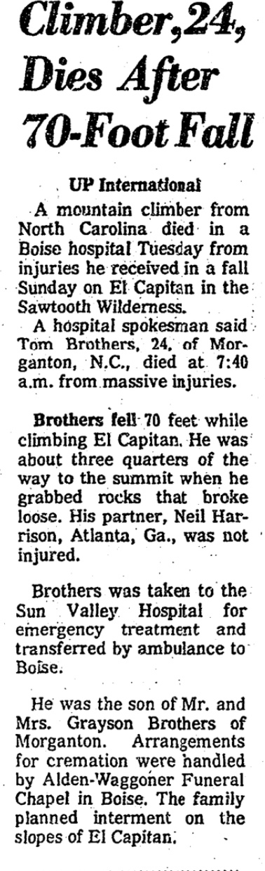
    Fatal mountaineering accidents are rare in Idaho, but they do occur. Rarer still are fatalities from Summertime avalanches. Most people associate avalanches with Wintertime, and Winter is when most avalanches do occur. However, for climbers, it’s the Summertime avalanche that can be an overlooked risk.

    Stanley, Idaho resident Jared Spear died on Castle Peak in a rare Summertime avalanche. His friends discovered that he was missing and initiated a search. An air search located his truck at the Castle Peak trailhead on July 6 and spotted a fresh avalanche on Castle Peak. Jarad was an experienced snowboarder.

    Sawtooth National Forest Avalanche Center Report

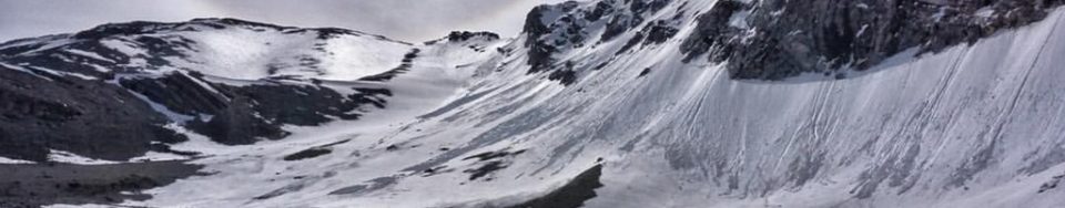
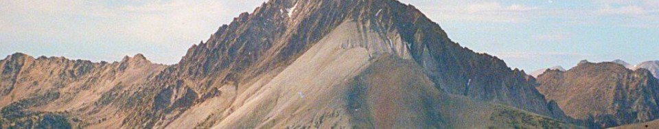
    Saturday, July 2, 2005, a snowboarder (male, 31 years old) was killed while doing a solo, one-day ascent and snowboard descent of 11,815-foot Castle Peak. He was descending late in the afternoon and tracks show that he completed 3 or 4 turns below the summit and triggered a point release, wet slide that grew in size. The slide was triggered and ran in steep, rocky terrain and dropped over 1,000 feet. The debris consisted of snow, dirt, and many loose rocks that had been entrained in the slide, indicating a full-depth wet release. Deep posthole tracks were observed climbing up sections of the face so he was aware of the wet, loose nature of the snowpack.

    The victim was not buried and appeared to have died of trauma and exposure. He was reported missing on Wednesday, when he did not show up for work after the holiday weekend. His body was located Thursday morning (July 7) by a group of local friends and searchers and evacuated by Sawtooth Forest helicopter Thursday afternoon. The slide was on the North Face of the 11,815-foot peak and the victim was found at 10,600 feet.

    Although point release, wet slides are always a Summertime concern, the high mountain snowpack has been unusually loose and wet at high elevations this Summer. We have not seen the development of a typically denser Spring and Summer snowpack this year. This is due to a combination of a weak shallow snowpack throughout the entire Winter, large amounts of snow at high elevations during May and very poor overnight freezes since early June.  Reported by Janet Kellam, Director, Sawtooth National Forest Avalanche Center.

    Idaho Mountain Express and Guide Article

    Seve Benson of the Idaho Mountain Express and Guide  [Sun Valley’s retired newspaper (2014)] wrote the following article about the incident and the effort to create a Search and Rescue team as a result of Spear’s death. The full 2005 article is located below and also in the paper’s online archive, currently located here.

    Wednesday, July 27, 2005

    Stanley seeks to start search-and-rescue team

    Friends of deceased snowboarder criticize rescue effort


    By STEVE BENSON
    Express Staff Writer

    Friends of Jared Spear, a Stanley man who died after triggering a wet-snow avalanche on Castle Peak on July 2, are leading efforts to form an official search-and-rescue team in Custer County.

    During a meeting with local law enforcement agencies in Stanley on Monday morning, several of Spear’s friends criticized the Custer County Sheriff’s Department for its limited role in the search and recovery of Spear’s body from the peak in White Cloud Mountains.

    Spear’s friends were responsible for organizing the search and locating his body. They felt the Sheriff’s office could have done more in the early stages of the search and displayed poor communication throughout the ordeal. They also blasted Custer County Sheriff Tim Eikens for providing information to the media before members of the search party had conducted their own reports of the incident.

    Eikens commended the search party, but also reminded all in attendance that his office was not notified that Spear was missing until the afternoon of July 6. He added that his office did all it could under the circumstances. “Before we put anybody at risk (in a search process), we have to know all of the information and there wasn’t a lot of information,” he said, adding that he did not even know the identities of the people in the search party.

    Addressing the communication issue, Custer County Sheriff’s deputy Mike Talbot said it was not intentional as technical difficulties hampered radio communications. But Eikens did not want to argue about what happened and focused instead on how to improve search-and-rescue efforts in the future. “We’re here out of respect for Jared,” Eikens said. “We’re trying to make something positive out of something negative. “This is not fun, it’s a traumatic event … but we need to support each other, and get your people to become part of the team.”

    Custer County, unlike Blaine County, does not have an official search-and-rescue team that acts in conjunction with the Sheriff’s office. The search party—comprised of 10 of Spears friends—found his body in the early morning hours of July 7. Upon discovering he had been missing for several days, they organized an impromptu search party on the afternoon of July 6. A reconnaissance flight over the area on the afternoon of July 6 located Spear’s truck at a Castle Peak trailhead—deep in the White Cloud Mountains—and spotted avalanche debris from a large wet slide on the peak’s North Face. Not knowing whether Spear was alive or dead, the party coordinated an all-night effort that included travel on foot and motorbikes. Spear was found in a boulder field about a thousand feet below the summit. He was 31 years old.

    According to a report written by Sean Tajkowski, who was a member of the search party, the avalanche ran about a thousand feet through steep, rocky terrain. Tajkowski said Spear was never buried by the debris and was not immediately caught by the slide. He added that Spear filmed part of his descent with a hand-held video camera and that the recovered footage supports his conclusions.

    Pete Isner, Custer County Deputy Coroner and a member of the Stanley Police Department, said Spear died from trauma suffered in the slide. Isner said his investigation remains open since he has not received all of the information from the field, but he believes Spear died soon after the slide, squashing any rumors that he may have survived as long as 24-48 hours after the accident.

    Kirk Bachman, founder of Sawtooth Mountain Guides, acted as the coordinator of the search for Spear. He did not criticize the Sheriff’s office and expressed his support of the creation of a Custer County search-and-rescue team. He also commended Eikens for being supportive of such an endeavor. “The Sheriff’s office is the legal authority on any search and we want to work with you guys,” he said.

    Eikens said when he first came into office two years ago he tried to create a Custer County search-and-rescue team but found little interest from local residents. After three hours of discussion, which included the full reading of a separate report prepared by Bachman and Tajkowski, Talbot passed around search-and-rescue applications. Almost all of the dozen or so citizens in attendance filled out an application.

    Talbot encouraged those who wished only to lend resources, such as all-terrain vehicles, horses, boats or aircraft to search-and-rescue missions, to sign up and specify their potential contributions. “We’re moving in the right direction,” Bachman said during a break in the meeting. “We’ll hold more meetings and focus on training and better communication.”