Category: Lopez

  • The First Ascent of Triple Peak

    The First Ascent of Triple Peak

    ARTICLE INDEX


    The second edition of the book discussed the then unnamed Triple Peak as follows:

    Peak 11280+                                                               11,280+ feet (Rating unknown) 

    This complicated tower, the southernmost summit on the Corruption/Breitenbach divide, is probably unclimbed. It is located 1.5 miles northeast of Mount Breitenbach. It is the steepest, most rotten looking summit in the entire range. Access the base of the peak from Breitenbach Pass [(A)(6.1)(a) or (C)(3.2)(a)]. USGS Leatherman Peak

    It was the only peak that I put in the book that I was sure had never been climbed. I thought I would give others a chance to make the first ascent but I had every intention of   being the first to reach its summit.

    Triple Peak in all its majesty viewed from the north. George a Reinier Photo
    Triple Peak in all its majesty viewed from the north. George a Reinier Photo

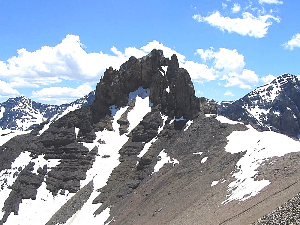
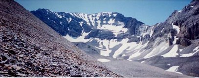
    The peak first caught my attention when I reached the top of Mount Breitenbach in 1991. The peak’s multiple towers dominated the view to the northeast. It looked like a difficult climbing problem. Triple Peak is a complicated summit located on the treacherous Mount Corruption/Breitenbach Divide. Triple Peak is composed primarily of Challis Volcanic rock which was deposited on top of the Lost River Range’s limestone base. The rock is as rotten you can find in Idaho. It was clear that the peak’s poor rock quality would be the biggest obstacle facing climbers.

    I mentally added the peak to my exceedingly long climbing todo list. At this time I was working on the second edition of the guidebook and many other peaks across the state had a higher priority than that rotten towers I observed from Breitenbach’s summit.

    Eight years later the second edition of my book was scheduled to hit the books stores in late Summer 2000. I decided I should make an attempt before the book was sent to the printer or someone else got ahold of the new edition and beat me to it. Little did I know that it would take me four tries over four years to discover the secrets of the towers that make up the peak.

    Triple Peak, 11,280, from Brietenbach. Beyond is Bell Mountain.

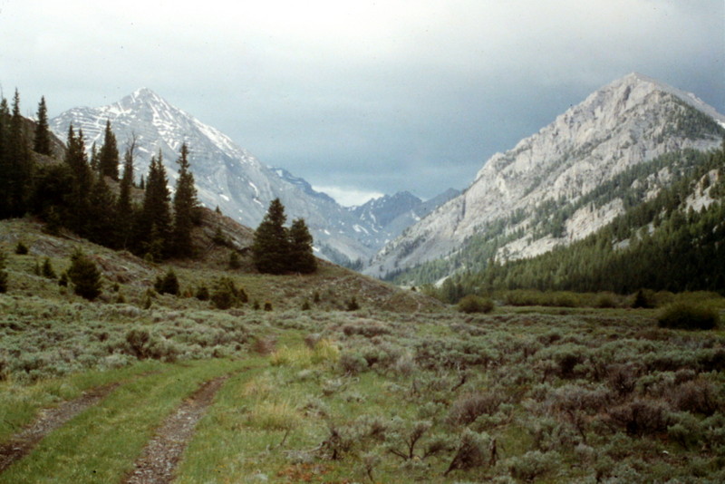
    The first attempt took place in late June of 1996 with Scott Mcleasch.  We were surprised to find that unusually high water would keep us from driving across either Dry Creek or the upper Pahsimeroi. We turned to plan B which was to begin from West Fork Burnt Creek, climb Cleft Peak and then traverse the connecting ridge to Triple Peak. This was a long approach and I was not having a great day. When we reached the summit of Cleft Peak, the view of the connecting ridge and Triple Peak’s east tower  was not encouraging. We decided to call it a day. Cleft was a nice consolation prize and at least I learned that the traverse, while it might be work, was not an efficient route to make the summit.

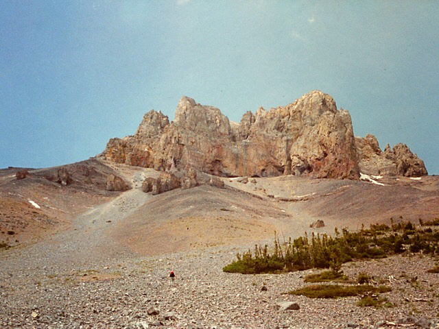
    The second attempt took place in 2000 with Brian and Karen Wright. This time we were able to ford Dry Creek and reach the trailhead. At one time a good trail climbed up Dry Creek, crossed Breitenbach Pass and descended down the Pahsimeroi River. In 2000 the trail had not been maintained in many years. We hiked up the poorly maintained trail toward Breitenbach Pass. At 8,600 feet we decided to leave the trail and climb the talus directly to the base of the east face of the summit block aiming for its southwest corner. It was a long, loose and tiring trudge. The higher we got, the looser the talus got. We finally reached the summit block and began looking for a line we could climb. The block’s face was mostly vertical. We tried a crack and a gully without finding a suitable route. We then climbed around to the peak’s south ridge and spotted a suitable line. However, it was now late in the day and, as working stiffs, we had to call it a day.

    Karen Wright leading us up the peak’s east face across endless scree.
    Looking for a line up the east face.
    Exploring a dead end.
    The rock face had potential difficult lines on hard rock. Since we were not sure if these lines would lead to the true summit we were not enthusiastic about trying them.

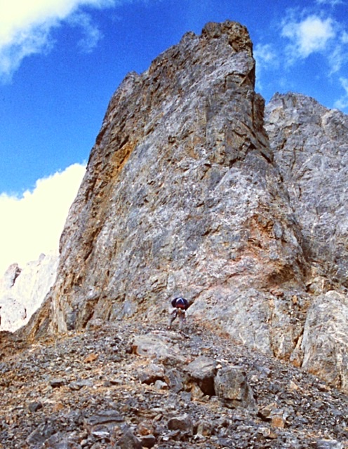
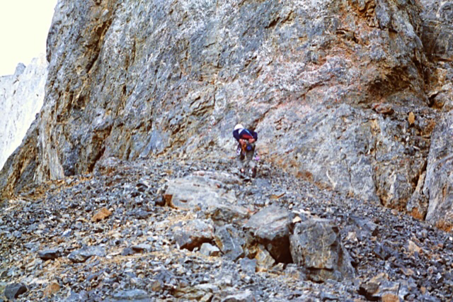
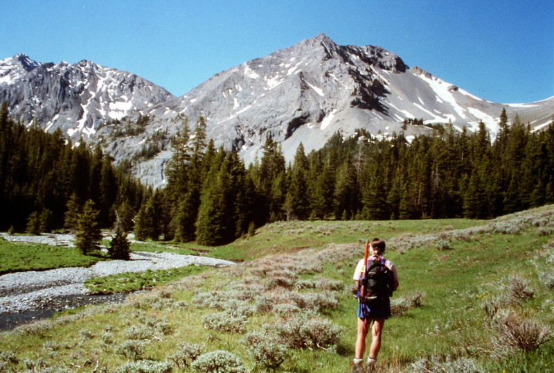
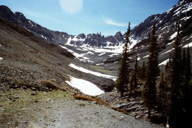
    On the third try in 2001 Brian and I backpacked up the Pahsimeroi River and set up a camp at 8,800 feet. The next day we hiked to Breitenbach Pass utilizing the trail where it existed and the mostly open slopes where the trail disappeared. From the pass we had a good view up the peak’s southwest ridge. The tower that loomed above us looked imposing but there was a split in the vertical wall that looked like a potential line to start our ascent. We hiked up to the base of the tower and roped up.

    Looking at the summit towers from Breitenbach Pass.
    Time to harness up at the base of the west tower.

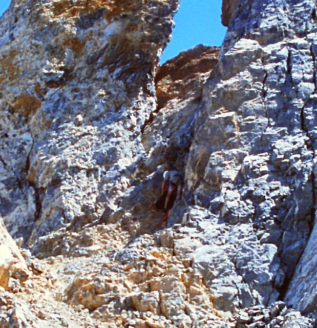
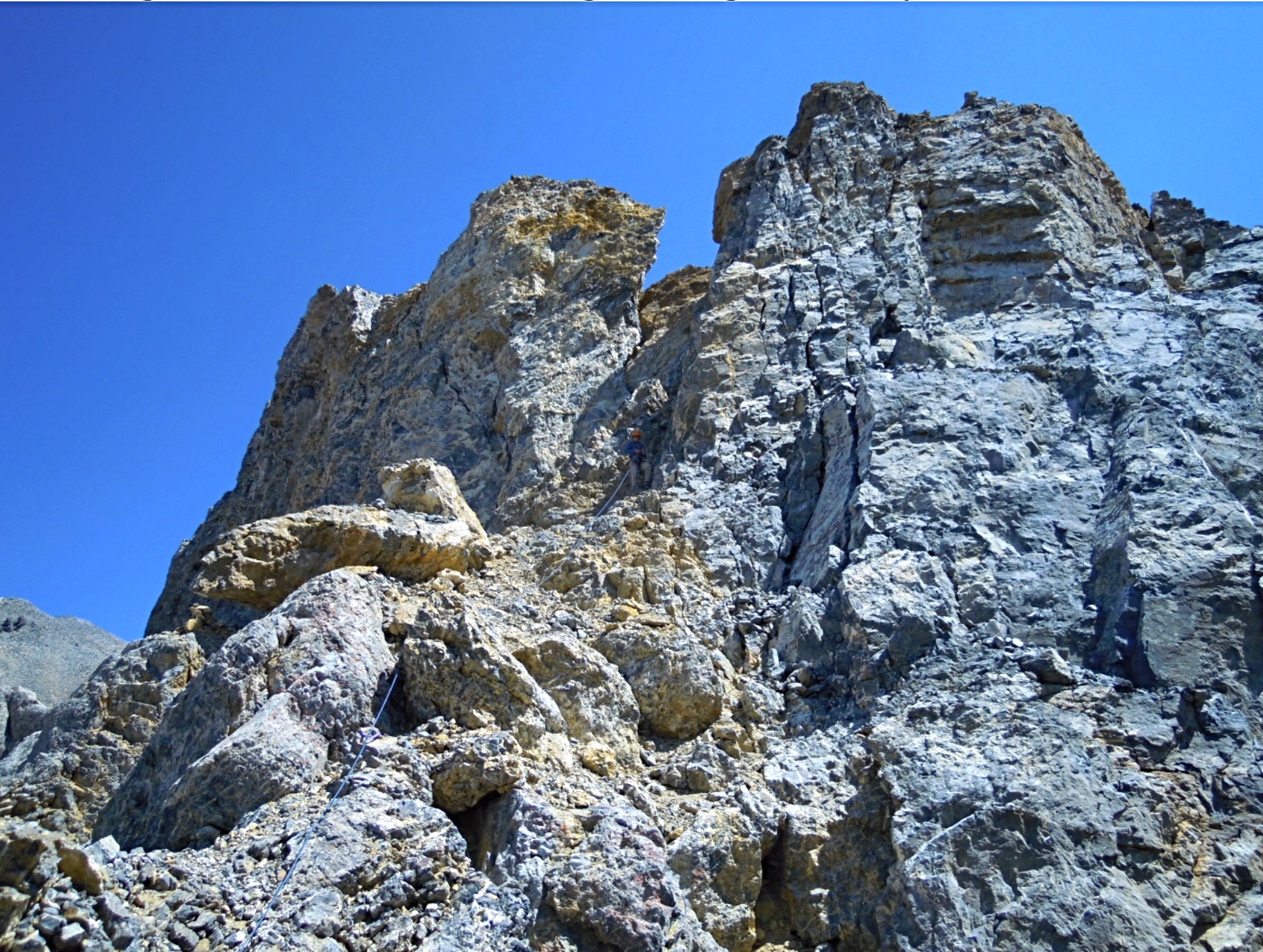
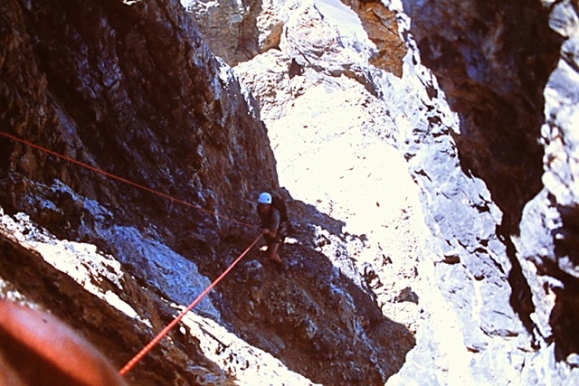
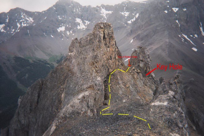
    I started up the steep gully that cut the tower’s face cognizant that the rotten rock was not conducive to roped climbing. First, I traversed to the right off the ridge top climbing over boulders and talus for about 150 feet to the base of the steep, slippery, debris-filled gully that split the face. I carefully climbed up the gully crossing loose talus in places and a series of hard ledges covered with loose rock. At the top of the gully, I was in an alcove capped by a 12-foot-high Class 3-4 wall. At the top of the wall I found a narrow hole or keyhole that exited out of the alcove to the northeast. I set an anchor and looked through the keyhole and discovered we had options to continue the ascent. I put Brian on belay and brought him up.

    Looking down the dirty gully from the Keyhole. Judi Steciak and Carl Hamke Photo

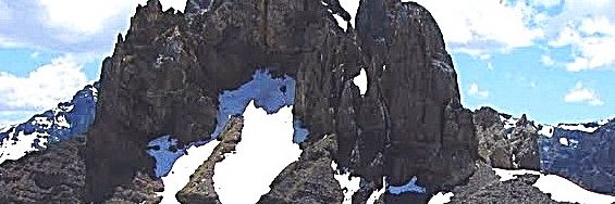
    We climbed through the keyhole and continued to climb up, unroped, across Class 2-3 debris until we found ourselves at the base of the southwestern most tower’s highest point. Above us was a vertical 75-foot wall shaped like an open book. The wall’s was composed of hard or at least harder rock than we had already crossed. It appeared this feature would lead to the top of the tower without too much difficulty. To the left, we could see a ledge system that appeared to traverse the base of tower’s north face. Access to this ledge would involve crossing a steep rotten gully and climbing a 25-foot-high nearly vertical wall of dirt and debris. From our perch any further the view northeast along the summit ridge was blocked.

    Looking back at Carl Hamke on a later ascent climbing through the keyhole. Judi Steciak and Carl Hamke Photo
    The view from the keyhole looking toward the base of the open book. Judi Steciak and Carl Hamke Photo

    Since we had no confirmation of which of the peak’s three towers was actually the highest (we did suspect the middle tower was the highest) we debated our two options. First, we could climb the tower we were on which would at least help clarify the highest point issue. Second we could descend down the very steep, loose debris filled gully and see if we could locate a route out of the gully at some point which would allow us to traverse northeast toward the notch between the West Tower on and the middle tower. In sum we had to choose between a descent of unknown length into the unknown on loose and unconsolidated crud or a climb to the top of the tower we were on relatively hard rock. It really was not a choice that was hard to make. We did not consider attempting to climb out of the gully via the 25-foot dirt wall.

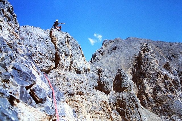
    We set an anchor. I put Brian on belay and he made short work of the climb. We rated this short 75-foot section at 5.7. He belayed me up. As I reached the top I detected disappointment on Brian’s face. He didn’t say anything. He just point to the next tower which was undoubtedly higher. Although it was higher it was obviously a Class 2 scramble from the intervening notch. Between us and the notch was a hundred foot vertical drop, a drop that didn’t look conducive to down climbing. “Okay,” I said, we need to rappel down the 100 foot drop into the notch.

    Brian on top of the tower.

    We spent the next thirty minutes trying figure out a safe way to set up a bomb proof rappel anchor cognizant that we would also have to use the anchor to safely protect ourselves when we had to climb back up wall on our return. There was horn we could safely use to rappel down our line of ascent but it’s shape would not work for a rappel down into the notch. The rope would slide off it. Our effort to set an anchor proved futile. It was impossible for us to set an anchor to rappel into the notch between the two towers with the equipment we brought.

    While the route from the notch to the summit looked an easy walk, it was late on Sunday afternoon, we still had to backpack out to the truck, make the six hour drive back to Boise and we both had to work the next day. We gave up and vowed to return. The Summer passed by without an opportunity or the desire to return.

    Brian rappelling off the tower.

    In 2002, I broke my leg sliding into second base in a softball tournament in early June. (I was safe by the way). After surgery, recuperating and physical therapy it was late September and my leg was too weak for serious climbing. I settled for easier climbing until the snow flew.

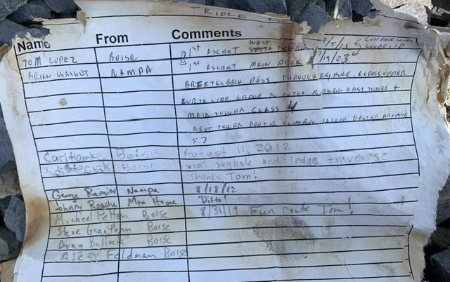
    Finally, on July 19, 2003 Brian and I found ourselves once again at the base of the southwestern most tower. Based on our prior adventures, we decided that the best route was to climb the southwestern tower again, set up some south of Rube Goldberg rappel anchor and rappel into the intervening gap and finish the climb. We took an extra rope, a bolt kit and 100 feet of sling, ascenders in hopes that we could fashion a safe rappel anchor someplace on the tower’s rotten summit.

    Once again we packed up the Pahsimeroi River and set up camp. In the morning we hiked up to Breitenbach Pass and then hiked northeast up the ridge to the base of the wowed. This time we climbed the dirty gully to the keyhole without roping up. We climbed through the keyhole and up to the base of the open book.

    While Brian was setting up an anchor to begin the climb up the open book, I stared at the ledge to the rotten 25-foot wall blocking the way and the view. After wondering for two years what was on the other side of the wall and whether it connected with the ledge I made up my mind. I decided to take a look. Brian put me on belay and I edged across to the gully to the base of the wall and started up. It was like climbing an overhanging road cut. Dirt and rocks streamed down around me but it was not as bad as I had imagined two years earlier. When I reached the top and looked over the top, I found a rather wide ledge that traversed the remaining section of the Towers north face which lead into the notch. From that point on, the climb was a walk across talus and boulders.

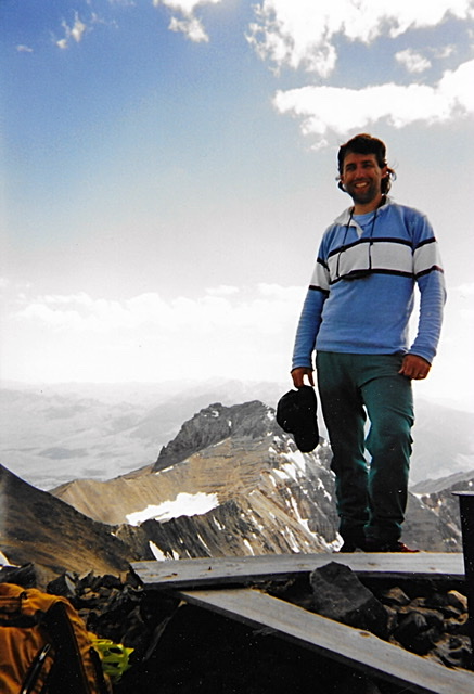
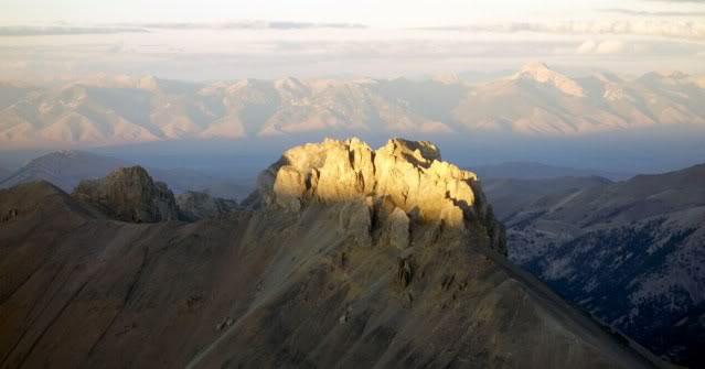
    As we reached the summit, the East Tower came into view. We could not say with certainty that we were on the highest point. We had to check with a spirit level to be certain that we had the first ascent.

    Looking from the summit down the upper route. The West Tower is roughly 25 feet
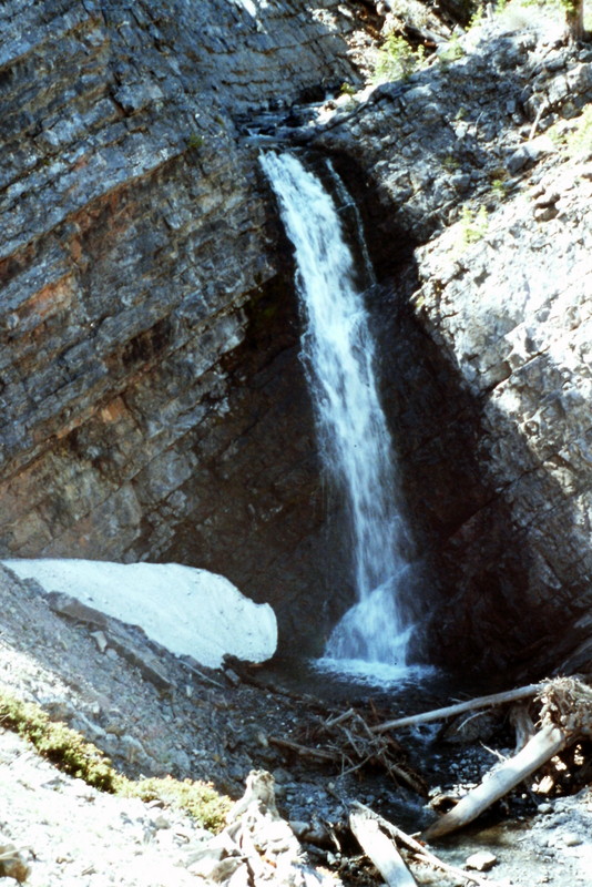
    lower than the summit.
    The register that Brian and I left on the summit. Haylee Stocking Photo
    Brian on the summit with East Tower
    in the background.

    Next: Sierra Nevada Day Hiking


    ARTICLE INDEX

  • Summit Idaho by Outdoor Idaho

    Summit Idaho by Outdoor Idaho

    In 2013, Idaho Public Television’s iconic series Outdoor Idaho broadcast a show dedicated to mountain climbing in Idaho. The show included ascents of Vienna Peak in the Sawtooth Range, Scotchman Peak in the Cabinet Mountains, Gilmore Peak in the Lemhi Range, and He Devil in the Seven Devils Mountains. Click on this link to view the show courtesy of Outdoor Idaho. Many of the contributors to this site were involved in the show, which is an excellent introduction to climbing opportunities available across Idaho.

  • Lost River Climbers

    Lost River Climbers

    Back in the 1970s when I started to climb, it seemed as though every climber was associated with some sort of climbing club. Some of these clubs were organized with large memberships and others were amorphous amalgamations of small groups of climbers who came up with a club name when they signed a register, but after a climb or several climbing seasons never proceeded to create a formal entity. The Lost River Climbers was derived from this tradition. This club had no legal formation, no dues and no officers. To join the club all a person had to do was to climb Hawley Mountain in the Hawley Mountains under a Full Moon in June, July or August.

    In 1980, I was running Young Adult Conservation Corps and my crew spent two years from March to November building fences and other conservation projects. We had our camp along Wet Creek on the North Side of Hawley Mountain, a few miles west of Clyde, Idaho (a town that has since disappeared). Every day, we looked at that mountain. Although we worked hard, the crew kept asking if we could climb the peak. So one night in June, the crew and I climbed the peak under a Full Moon and the Lost River Climbers Club was born.

    The next year, I had a different crew and that crew also found the lure of Hawley Mountain irresistible and we once again climbed the peak under another Full Moon.

    The Lost River Climbers T-shirt.
    The Lost River Climbers T-shirt. Accept no such substitutes.

    In 1980, there wasn’t much in Clyde, Idaho other than a one-room schoolhouse that was still in use. For me, Clyde was the center of the Lost River Country and so it became the home of the Lost River Climbers.

    There was a one-room schoolhouse holding classes in Clyde until the mid-80s.
  • The First Ascent of the North Face of USGS Peak

    The First Ascent of the North Face of USGS Peak

    ARTICLE INDEX

    The North Face of USGS Peak

    I wrote this article about the first ascent of the North Face of USGS Peak for the Idaho State Bar magazine, The Advocate. They wanted me to write an article to demonstrate that attorneys could have a life apart from their legal practice. This article recounts the first ascent of the North Face. It was originally published in The Advocate, published by the Idaho State Bar in the July 1997 issue, Volume 40, No. 7. The peak’s page is found at this link: The climb took place in August 1995. USGS Peak


    I climb with my wife. For us, spare time means weekends and vacations. The typical climbing weekend begins as the prior weekend ends. As our truck reaches the pavement. Dana, my wife asks “What shall we climb next weekend?”
    “I’m not sure I can go. I have a hearing the following Monday.”
    “Can’t you get ready before the weekend?”
    “I’ve got to write three briefs this week. I’ll have to work all night.”
    “The weather can’t last forever. We should take advantage of it.”
    “I know, I’ll work late.”
    “Me too. What shall we climb?”
    “What shall we climb?” is a loaded question for us. Its kind of like “to be or not to be?” for poor old Hamlet. There are too many options, too many summits. We talk about the options and then agonize about the decision because time is so limited.

    Monday and Tuesday. Work, work, work. At home, it’s chores. At lunch, its running. In between, we pick a peak: The North Face of USGS Peak in the Lost River Range. To our knowledge, the face has never been climbed. Its one of those peaks that has haunted us for a long time. Three earlier attempts on the peak over the last 15 years came up short. One brief is finished.

    Wednesday. Wednesday evening is usually the drop-dead date for packing and planning. We must collect the maps, pick the route, pack the packs and buy the food because we will be too tired on Thursday. Brief number two is done by 4:30PM.

    Thursday. Its time to finish the third brief and draft an outline for the Monday morning hearing. A new case comes in and I find an answer is due by today. Between witnesses and opposing counsel, too much time is spent on the phone. I run at lunch time. A case settles, gotta draft a release, oops, time to go home. At home, the garden needs water and the equipment needs checking. We look at the maps and go to bed.

    Friday. The drive to the East Side of the Lost River Range will take at least 5 hours, so we plan our escape for the early afternoon. The third brief is done. At 3:15PM, we are in the truck and heading for the freeway. From Boise, we drive east to Bliss, Shoshone and Arco. Lava fields and small towns pass by and the mountains to the north and east grow closer. At Arco, we buy gas and drive east to Howe. Its 6:00PM and we are pointed north on Little Lost River Highway.

    The good roads end at Clyde. We follow the Wet Creek Road west to the Dry Creek cut-off road which runs northwest. At about 6:45PM, we arrive at the shattered Dry Creek Dam which was, according to one story, blown up as a result of a water rights dispute in the 1920s. We stop for a break. The most difficult 4 miles and hour of the drive are ahead. The sun is dipping down behind the Lost River Range Crest. The shadows bring coolness.

    The road down from the top of the dam is reminiscent of a roller coaster ride. One turn and the road is nothing more than a talus slope which pitches out and sharply down at a wicked angle. The Jeep bounces and stammers, the wheels throw gravel and its over. I release my death grip on the steering wheel.

    It’s now time to ford Long Lost Creek for the first time. The creek is wider than I remember, but we plunge in anyway, making waves with our bumper. The gravel stream bed supports us and we cross without incident. Its starting to get dark. In another mile, we cross the creek again. A quarter mile farther and we reach a grassy, water-logged meadow. The stream has divided into numerous rivulets which liquefy the earth. No cell phone will reach a tow truck from this remote spot. We have visions of the truck sinking into the meadow and, tired of driving, consider setting up camp without crossing the meadow.

    We realize that if we do not continue, we will have a much longer climb the next day. So we go on. Mud oozes and water sloshes around the truck. We creep from one mud hole to the next, finally reaching the mother of all mud holes. “What do you think?” Dana asks. “Someone drove through here,” I say without much confidence. We explore the mud hole on foot, it has a bottom, and we drive on. Suddenly, it’s over. There is dry ground under us. The road is now surprisingly good and the last bit goes quickly. We have made it to the proverbial end of the road.

    The Long Lost Valley is a difficult place to reach but well worth the effort.
    The Long Lost Valley is a difficult place to reach but is well worth the effort.

    Time to make camp in the twilight. The tent goes up, the sleeping bags are unpacked, the headlamps and novels are thrown in the tent, water is located, a late-night snack is gobbled up and suddenly it’s quiet. Massacre Mountain, a long hulking ridge, towers above one side of the valley while the canyon walls on the other side of the creek climb to the summits of several unnamed peaks. A deer crosses the meadow. The wind shifts slightly and the sound of the creek rolling down the canyon reaches our ears. It’s cool now. The trees sway with the breeze and I fall asleep while my untouched novel lays at my side.

    Saturday. Well, OK, not the crack of dawn but a respectable 7:30AM. Time for a quick breakfast, then we load the packs. At 8:10AM, we’re on the trail, an old trail that has seen little use in the last 25 years. We hike through stretches of fir and pine separated by sagebrush-covered flats toward the headwall at the end of the canyon. The trail has disappeared. As the route climbs up a steep slope through an avalanche run, my legs remind me that it’s going to be a long day.

    After the road ends there is a sketchy trail that can be followed in places. It is for the most part missing in the meadows but locatable in the trees.
    After the road ends, there is a sketchy trail that can be followed in places. It is, for the most part, missing in the meadows but appears in the trees.

    A short distance ahead, we encounter a 100-foot waterfall dropping over vertical rock walls. Following the stream is out of the question. We located a route and start up the side of the canyon. The detour involves climbing 200 feet up a steep, dusty slope. From this point, a 75-foot loss in elevation brings us back down to the stream above the waterfall. The next obstacles (two smaller waterfalls) are not as time consuming to bypass. An hour has gone by.

    The highest water fall along the approach route.
    The highest waterfall along the approach route.

    A detour around a 4th waterfall brings us to a spot where the valley opens up into a hanging valley. A small tributary stream flows down from a side canyon, tumbling out of a long snow slope. Our route climbs up this slope to the cirque above. Do we get out our ice axes and crampons to climb the snow or do we climb the rocks to the left? Decisions, decisions. We opt for the rocks to save time. The slope is at least 300 feet high (100 feet higher than the Capital’s dome in Boise) and it takes us nearly 30 minutes to navigate our way to the top.

    Above the waterfalls the valley opens up into a spectacular high valley.
    Above the waterfalls, the valley opens up into a spectacular high valley.

    One hundred yards farther and we reach a small pond fed by melting snow. A thin glaze of ice covers its surface, a sure sign that the elevation is well over 10,000 feet. From the pond, we catch our first glimpse of the North Face of USGS Peak. The face is steep (as we knew it would be) but wow, it really looks steep. Slender snow ramps climb up the shadow-covered face. We snap a couple of photos and look at the wall through a monocular. Dana suggests a possible route. We discuss it. I give it my benediction, “Yes, it will go,” meaning that there are no obvious obstacles and what we see ahead of us doesn’t scare me.

    The North Face of USGS Peak.
    The North Face of USGS Peak.

    The intervening terrain is strewn with boulders and patches of snow. Although we picked the easiest route across the broken surface, it still takes 20 minutes to arrive at the face. It’s now time to unpack the ice axes and crampons and to decide whether a rope is necessary. The 1,500-foot slope above us rises at about 45 degrees. We opt for speed and leave the rope. Our ice tools are our only protection. The first pitch is 200 feet high, steep and the snow covering is still rock-hard in the morning shadows. At times, we hit water ice and neither the points of our crampons or the pick on our ice axes will make a dent. We use our ice axes to cut several steps across the ice and soon reach a rock buttress. Rather than remove our crampons, we climb up with our crampons clinking and scraping on the rocks. The footing is good and we scramble up the rock to the base of a snow chute that climbs to the summit ridge, another 1,000 feet above. Another hour has passed.

    “It looks good.” We are now 500 feet up the slope and the base of the cirque is spread out below us like the view from an airplane. The tops of the ridges that enclose the cirque are nearly level with us but the summit ridge seems no closer than it was 30 minutes earlier. We use our axes to cut a small platform and sit down to rest. The snow has varied in quality as we climbed, from “Styrofoam like,” to water ice, to unconsolidated, rotten snow where we have fallen through the crust to our waists. Anything that gets loose on the slope will end up in the rocks 500 feet below in no time at all.

    We continue cutting steps across water ice. Our quadriceps ache and our calves cramp, but we go on. We reach a rock band which constricts the snow chute and climb onto it for a change of pace. The rock quickly becomes too steep and we move back onto the snow. I’m counting my steps now to take my mind off my weariness. I set a goal. I’ll try to go 200 steps before I rest. I make it to 247. Time to cut more steps. Dana takes the lead. Each blow from the ice ax sends a cascade of ice down the slope. The air is completely still except for our labored breathing. Above the water ice, the slope moderates and the summit ridge cuts the sky. Another 15 minutes and we are on the summit ridge. The summit ridge is narrow but easy walking and we soon reach the top.

    A small register in a can records only the name of Rick Bauger of Idaho Falls who climbed the peak from the south one year earlier. We snack, enjoy the view, discuss other possible routes on the peak and drift into our own little worlds. The wind picks up, reminding us that it’s time to go down. We both know the descent is probably more dangerous than the climb up. We say nothing. We’ve climbed together for nearly 20 years and safety concerns are communicated non-verbally. Two hours later, we are back in camp.

    Sunday. Sunday we follow a trail to a nearby lake and hike to the top of the high point above it. It’s a nice change from the icy North Face but its anticlimactic. We still have the return hike, the swampy meadow, 2 river crossings, a talus slope and a 5-hour drive ahead of us. We decide to start for home. The next trip must be planned and, somehow, we have to get our heads back into our work.

    Monday. “May it please the court…..”

    On the summit.

    Next: Peakbagging in Glacier National Park


    ARTICLE INDEX