Category: Mount Borah

  • 1977 Borah North Face Winter First Ascent

    1977 Borah North Face Winter First Ascent

    Bob Boyles, Mike Weber, Art Troutner and Frank Florence made the first Winter ascent of Borah’s North Face. Below you will find one of the few photos they took during the 16.5 hours they climbed and photocopies of 2 Idaho Statesman articles published at the time. Below you will find reminiscences of the climb from Bob Boyles and 3 Idaho Statesman articles which covered the climb.

    Bob Boyles offered these details:

    We climbed the North Face on January 8-9, 1977. The only reason we even considered doing the face in Winter was the drought of 1976-1977. The Winter started out very cold and dry, and it had only snowed a couple of times before we went. So we rolled the dice and hoped the face wouldn’t be loaded up and, luckily, it wasn’t. We got into waist-deep unconsolidated sugar snow on our descent, but it went all the way down to the rocks below and wouldn’t slide. It was weird because when you walked through it, it would push the snow 10-20 feet in front of you.

    When asked about avalanche danger Bob pointed out that:

    The North Face of Mount Borah has only been climbed two times in Winter to my knowledge and both were in 1977, two weeks apart. We did it first and another team from Ketchum (or maybe it was Idaho Falls) did it two weeks later after the cold spell passed. It never got cold again all that Winter.

    What made the climb possible was the drought of 1976-77. During a normal Winter, the cirque would be a pretty risky place to climb. A couple of years after our Winter ascent, we went up in late September and, over a mile from the face, ran into the avalanche debris that carried Bruce Otto’s snow measuring equipment out of the cirque.

    When we got over the cliff band and got a close look at the face, we could see that the whole thing had slabbed off leaving behind a 6-foot crown. The bivy site where we usually stayed was covered in maybe 30 feet of rubble. Realizing that more of the slab might come off, we hugged the left side of the moraine and did a different route far to the left of the face.

    Curt and I did the North Face Direct the next year and the crown was still there presenting a short, vertical step that we had to climbed over. A few years later, another one came down the gully that crosses the main trail to Chicken-Out Ridge. Most people walk right through it without realizing what it is. That slide snapped 4-foot trees like toothpicks and ran at least a mile.

    Bob pointed out the 1977 conditions were an extremely rare occurrence:

    I fish for salmon and monitor the USGS Idaho streamflow site daily during the season. From USGS records, most of the all-time low streamflow rates for Idaho rivers were set in 1977. Those kind of conditions don’t happen very often and we knew it before we went for the North Face. We figured we’d get snowed out before we could get a climb in that Winter. If we had waited one more week the temperatures warmed (for the rest of the Winter) and we would have missed the arctic air mass that had set in. But…no one expected we’d see that kind of drought, and the face could have safely been climbed all Winter.

    Bob also warns that “In a normal Winter, like we’re seeing this year, I would not go up on the face. One might be able to make it up the far left side of the cirque to gain the ridge, but that would bypass the entire face.”

     Bob Boyles supplied this photo, the only photo his team took on their winter ascent of the NF in January 1977. Frank Florence Photo
    Bob Boyles supplied this photo, the only photo his team took on their Winter ascent of the North Face in January 1977. Frank Florence Photo

    The first article discussed the upcoming attempt.

    Idaho Statesman Article
    Idaho Statesman Article


    The second article covered was an announcement that the climbers had succeeded. My copy was not in good enough shape to photograph so it is transcribed here:

    By TOM GROTE

    The Idaho Statesman 

    Four Boiseans Saturday successfully reached the summit of Mt. Borah, Idaho’s tallest mountain, the father of one the climbers said. Lou Florence, president of Sawtooth Mountaineering, said his son Frank Florence, Bob Boyles, Art Troutner and Mike Weber completed the climb in the dark about 5:30AM [Editor’s note: The original article listed the climbers addresses.]

    The climb was completed a day earlier than planned, Florence said, because the four did not have to ski part of the way to the mountain. “The wind had blown away the snow and they took  advantage of the good weather,” he said. Three of the 4 weathered in good condition. Boyles suffered frostbite on 3 fingers. “We won’t know how bad until we see them,” Florence said.   

    The climb to the top of the 12,622 foot summit was believed to be the first Winter ascent along Mt. Borah’s North Face. The climb began about 1:30AM Friday, Florence said his son told him during a telephone call from Arco after the climb. “They ran into a snowstorm a few hours after they started, but the weather then cleared,” he said. Two hours into the climb, the party ran into winds of 20-30 miles per hour, adding a significant chill to the 15-degree temperature, he said. All 4 climbers made the summit after. 28 straight hours of climbing, twice as long as expected.  

    The climbers did not stay long at the top and left no mementos, Florence said. “They were very elated when they reached the top,” he said, “but the bad weather forced  them to a take another way down than they had planned.” The four ate snacks during the climb. They were driving toward Boise late Saturday and were expected back around midnight, he said.  

    The usual Winter route to the summit ridge is on the Southwest Face, Florence said. Although the climbers were taking the more difficult route, they did not have the worst conditions possible. Deeper snow and colder temperatures hamper climbers in February and March, but a January ascent still qualifies as a Winter climb, Florence said. All four are experienced climbers, but only Frank Florence had prior experience on Mount Borah. In January 1973, he reached the top but lost the tips of 3 toes to frostbite. Another group tried to climb the mountain in July, but was forced down by winds up to 55 miles per hour.

    The third article sums up the expedition.

    Idaho Statesman Article
    Idaho Statesman article
  • Photos from the 1976 first ascent of the Direct North Face of Borah

    Photos from the 1976 first ascent of the Direct North Face of Borah

    Below you will find Bob Boyles’ favorite photos from the first ascent of the Direct North Face of Borah (October 1976). The North Face of Mount Borah is considered by some to be one of the finest alpine climbs in Idaho and one of the few faces that holds ice during most years. The lower face starts at around 45 degrees and steepens to around 55 degrees below the summit pyramid. This route takes the left branch of the main couloir until it ends at the short steep rock step (Class 5.7) and then follows low Class 5, Class 4, and Class 3 steps directly to the summit. In the early season (late Spring and Summer), this route is usually a steep snow climb. In late season (late Summer and early Fall), this route can be all hard alpine ice (10 pitches, WI3). In good conditions, this route can be climbed in a few hours. In poor conditions, this route can take all day. The Southwest (Chicken-Out) Ridge is often used for descent.

    Borah North Face Direct. Bob Boyles Photo
    Mount Borah’s North Face Direct Route. Bob Boyles Photo
    NFace0003
    Mike Weber “frenching up” on hard ice.
    NFace0005
    Bob Boyles high on the North Face.
    NFace0007
    Mike Weber at the start of the main couloir.
    NFace0009
    Mike Weber on belay below the crux pitch.
    NFace0011
    Bob Boyles topping out on the North Face Direct Route.
    NFace0012
    Mike on the summit of Mount Borah.
    NFace0013
    Bob on the summit of Mount Borah.
  • The East Face of Mt Borah by Bob Boyles

    Idaho has nine summits that reach over 12,000 feet and all but two lie within the Lost River Range in central Idaho. Idaho’s tallest and most visited peak, Mt Borah (12,662’), is located in the central section of the range. As the state highpoint, it is also very popular. During the summer months, it is not unusual to see a full parking lot and 50 or more people attempting to climb the mountain by its most popular route, the Southwest Ridge, or “Chicken-Out-Ridge” as it is more commonly known. For some classic snow or ice climbing, Borah also offers several hidden gems on its North Face, including routes written up in past editions of this journal. In spite of all of the traffic the mountain has seen, the remote East Face remained relatively unexplored and unclimbed until the summer of 2011.

    Geology

    Idaho’s Lost River Range is an actively uplifting fault-block at the northern end of the Basin and Range province. Extensional faulting has lifted the range relative to the down-dropped Big Lost River basin on its west side, producing steep ridges and slopes essentially devoid of foothills.  Interior and eastern regions of the range are deeply incised by the Pahsimeroi and Little Lost Rivers.  Most of the range, particularly in the central and southern regions, consists of thick layers of Paleozoic limestone and dolomite. Multiple episodes of tectonic deformation have resulted in dramatic open to isoclinal folding at a scale of meters to kilometers. Glaciation has carved numerous cirques throughout the range and alpine lake basins are scattered in the central and eastern portions. These combined activities have created an impressive assortment of large, high angled faces with western, northern, and eastern aspects.

    Background

    I first visited the eastern side of the Lost River Range (The Pahsimeroi Valley) in 1972, while working on a helicopter contract for the Forest Service. Flying through the range provided me a view that few ever get to see. While all of the range is impressive from the eastern side, one face stood out from the others. When our contract with the USFS finished at the end of summer, I took a break from the 24/7 aviation life I was accustomed to. During this down-time, I happened to notice an ad for an introductory rock climbing class and thought, “Wow. Cool. Ropes and everything, I’m game for this!” I talked a couple of friends into joining me for the class. After completing our class, we were ready to test our newly learned skills on a real mountain but winter soon arrived and we put our plans aside until the next summer.

    Summer came late in 1973. It wasn’t until the end of June that we were able to get in for a closer look at the East Face. As the morning sun warmed the snow high in the cirque, we watched slide after slide tear loose and nail virtually every approach to the mountain. Along with the snow slides came a lot of rock fall as well. After sitting and studying the face, it looked to be climbable. There was no doubt, however, that the attempt would have to be made during the dry season. In 1974 we returned for another exploratory trip and picked out a line on the face that followed some water streaks in a nearly straight path to the summit. We decided that this was the route we would attempt on our next visit.

    A couple of years passed. In trying to sell potential climbing partners, I described this face as “Idaho’s Eiger” but at the time, the range had no technical rock routes. Idaho has so much fine granite it was hard to justify a trip to the Lost Rivers, where the limestone rock had a reputation for being nothing but choss. In the fall of 1975, Mike Weber and I decided to throw caution to the wind and give this face a serious attempt. We loaded up all of the gear we thought we’d need and made the brutal drive to the end of the road up the West Fork of the Pahsimeroi River. Hiking through open sagebrush, we made quick work of the approach and found a nice grass-covered spot for our camp at the lower tarn just above timberline. Curious to see the face up close, we grabbed our crampons and axes and headed up the snow and ice to where the bare rock began. Just as we were approaching the final section of snow and the start of our proposed route, we heard a rumble from above, freezing us in our tracks. A Volkswagen-sized rock was flip-flopping down the face. Within seconds, it reached terminal velocity bouncing back and forth down the face. We stood motionless in our stances trying to figure out if we should go left, right, or just clasp our hands and pray. Fortunately, the rock deflected about 40 feet to our right. We just stood there watching it tear up snow and bounce to the flats and the tarn at the bottom of the cirque. We tried to convince each other that the face would be frozen up by morning but neither of us was to be convinced. Around 2:00 am we were startled awake by a blinding flash of light and milliseconds later, a rumble of thunder. We both knew our chances to climb were most likely over, so we pretended to go back to sleep. Within minutes, the rain was falling at a rate of an inch or two an hour, and shortly afterward our campsite became a flood zone. We stayed in the tent until it was surrounded by flowing water, our cue to get the hell out of there.

    For decades after that ill-fated attempt, my climbing partners and I continued to explore and put up routes in the range. Despite those many visits, we never made it back to the cirque. I pretty much wrote off the East Face as being a very dangerous place and that kind of risk no longer appealed to me. Also, as time progressed, I gained the impression that sport climbing and bolted routes on established climbs were the “new norm” and the pioneering of new alpine routes seemed to have gone by the wayside. It wasn’t until the spring of 2011, during a discussion of Lost River climbs on the Idaho Summits web forum that a new spark of interest began. When I first described the East Face cirque, most local climbers did not know what I was talking about. This, despite most of them having climbed Mt Borah multiple times. One did, though. After reading my description of the face, Wes Collins, a local climber and native of the area, immediately became interested. Soon, a new discussion started about taking a trip to the cirque.

    First Ascent – The Dirty Traverse Grade III 5.4
    Wes Collins (solo) July 2011

    Wes couldn’t wait to see the face up close so he took off on an exploratory trip with his wife and dog. This trip in 2011 started as a recon, but Wes found himself drawn to the face like a magnet. The following is Wes’ account of the first ascent.

    Bob got me all fired up to get a look at the eastern cirque and what he described as Idaho’s Eiger. I certainly wasn’t disappointed. Susan and I planned the trip as a leisurely backpack into Lake 10,204 to take in the views, but I tossed an axe and some light crampons in the truck just in case.

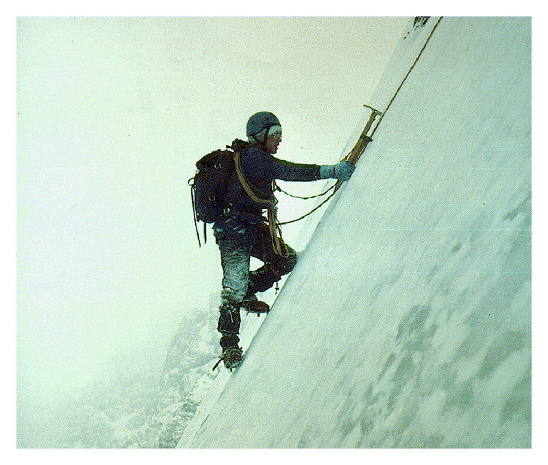
    I spent a lot of time looking at the face before I even thought about a spot for the tent. Stupidly, I’d left my axe and spikes in the truck, but at this point I knew I was going to make a serious try for the summit. It didn’t take long to pick out a couple possibilities, but the most probable line would involve a long traverse across a talus-covered ledge on the lower face. I started thinking of the route as the Dirty Traverse before I even put my boots on it. Morning was an easy laid-back affair. We sipped coffee and we watched the sun line slowly make its way down the mountain. I had to wait until nearly 10:00 before the snow softened enough for step kicking. The first, lower snowfield was pretty firm, but the second was much softer.

    I’d found a nice tooth-shaped chunk of limestone that probably wouldn’t have done much more than keep my feet down hill if I took a fall. I was on my own, but it was still embarrassing to have the damn thing in my hand and I had to keep fighting the urge to hide it in my pocket. At the top of the snow, the randkluft was several meters deep and the first tentative moves on rock over the blackness below felt pretty exposed. The rock, however, was surprisingly solid and clean.

    The scramble to the traverse ledge was fairly sustained Class 4, but the rock was good enough to make me forget about the exposure and enjoy the ride. The traverse ledge was quite tedious though and I wasn’t sure it would go all the way to the ridge until I got there.

    Once on the ridge I made my way up an easy Class 5 seventy foot buttress but it could have been easily bypassed by scrambling around its west side. Most of the ridge above the traverse is Class 3 or easier.

    As I continued up the ridge, my doubts got bigger. The entire north side of the East Ridge is very tall and overhung in several places. More and more I suspected it would dead-end into the headwall but at the last possible minute, a tiny col opened up onto the uppermost ledge that crosses the East Face. It wasn’t till that moment that I knew the ridge would go all the way. Splattski summed it up nicely in his trip report of JT peak as the almost magical opening of doors as you climb. This was one of the most fun parts of this outing. I couldn’t agree more.

    The descent follows the standard route down the mountain to the big saddle at 11,800. From there, I dropped into the cirque that takes in the south side of Borah and Mt. Sacajawea. There are several sections of Class 3/4 scrambling over short but loose cliff bands and several linkable snowfields, but the glissade run-out potential is pretty dangerous on most of the snowfields. At the 10,400 contour the angle eases up. From there I hiked down and around the bottom of the East Ridge and finally back up to camp.

    The East Face Direct III 5.9
    First Ascent Sept 24, 2011 Wes Collins, Kevin Hansen
    Second Ascent Sept 19, 2013 Kevin Hansen, Larry Kloepfer

    Start at the highest glacial lake in the East cirque and walk around the north side of the lake for easiest access. Angle your way around the bottom snow field and trudge your way up the scree until you reach the first rock band. This is an easy Class 2-3 scramble for 20 meters or so. Once on top, pick your path of least suffering up the scree to the bottom of the snowfield. Depending on where you choose, this class 2 scree slope is not friendly. Loose dirt and gravel are stacked at a 50 degree angle for a few hundred feet. Once at the toe of the snow field, find a place to strap on your spikes. The slope is around 45 degrees and it is wise to bring crampons. Depending on snow conditions, an alpine ice axe could help. Hop the randkluft and get onto the face. From here the world is yours. At first sight it looks like 80 percent of the East Face is 5.6 to 5.7 climbing which is a good rating for the first 4-5 pitches. East Face Direct follows a dark water streak that passes just left of the top of the “Super S” as Kevin called it. The “Super S” is a large obvious fold in the rock strata that composes the lower right quarter of the East Face. At any time, a team could climb side ways (off route) to the right or left a few hundred feet to avoid the more difficult sections. The direct route stays plumb with the top, following the dark water streak to find the best rock. Because most of the climbing is 5.6 – 5.7, groups may choose to simu-climb many of the pitches. Teams that wish to set up a solid anchor every rope length could discover the route is close to 9-10 pitches. As with all mountaineering, speed is safety. Several class 2-3 scree slopes divide the rock pitches. One short pitch was a solid 5.9 with a protection less small overhang. It’s the finest part of the route. Once past the final head wall, put the rope away and enjoy the last 300 feet of class 2-3 scrambling to the summit.

     
    East Face/Northeast Ridge Variation III 5.6 WI2
    First Ascent – July 25, 2012 Bob Boyles, Frank Florence

    While this route is not overly difficult, it does require a willingness to climb with long run-outs and minimal protection both at belays and while leading. Many of our belays were protected with a single piece of gear and most pitches only allowed for a few placements. Rockfall, both self-initiated and trundled from the summit is an ever present danger on this route.

    The route starts slightly to the right of Wes Collins’ Dirty Traverse route and follows the slab like ramps for about 6 pitches of 4th and low to moderate 5th class climbing until you reach the ledge system that allows for an exit to the Northeast Ridge. From there we climbed 2 pitches of very steep snow and joined the ridge. On the Northeast Ridge we encountered a short section of water ice (WI2) and several more pitches of moderate 5th class climbing until just below the summit, where it turns to easy, but very loose 3rd and 4th class climbing.

    This route is probably best done when there is some remaining snow to cover loose scree and talus (June – July) and during some years it may not be climbable at all due to the large cornice that can form and block the narrow exit to the Northeast Ridge. Parties willing to solo or simu-climb can reduce the overall number of pitches required on this route.


  • Borah: Where Gray Granite Crags and Idaho’s Azure Skies Meet  By DICK d’EASUN

    Borah: Where Gray Granite Crags and Idaho’s Azure Skies Meet By DICK d’EASUN

    Bob Boyles found and transcribed a scanned copy of the following 1929 article which discusses Mount Borah.


    The Idaho Sunday Statesman
    BOISE, IDAHO (SUNDAY MORNING MAY 29, 1932)

    Where Gray Granite Crags and Idaho’s Azure Skies Meet

    By DICK d’EASUN

    Up at the top of Idaho, supreme among Gem state giants of massive rock, rules Mount William Edgar Borah, mantled now with robes of gleaming snow, defying the elements to cut away its towering battlements. Pounded by millions of years’ geological transformation, ground under the heel of a mighty, rolling glacier, the lofty peak stands bold and tremendous, Idaho’s challenge to the majestic Tetons, the Alps of America.

    Not favored by the scenic beauty of thick timber, blue mountain lakes, and long vistas of granite crags rising abruptly from green forests that makes the Sawtooth Range and Lost River Mountains an inspiring wonderland, Mount Borah commands a little-traveled and only slightly-explored area of East Central Idaho. Though higher by nearly 600 feet than its closest rival, Mount Hyndman, the Dean of state mountains is not spectacular in its soaring glory. The surrounding area is of itself so high that the peak juts out unobtrusively and fails to attract the attention it would if its broad, steep sides of shale were cut in sharp relief in lower ground.

    The mountain, named for Idaho’s senior senator, is 12,655 feet above sea level at its crest. It is located 6 miles east of Dickey, a junction point near Willow Creek on the Mackay-Challis highway. Plainly visible to all persons who pass over the road on clear days, Winter and Summer, the peak is seldom noted by scenery seekers, expecting to find something towering like a church steeple above a city street as the greatest of all crags within the state. From the Snake River Valley more than 100 miles to the southeast, the crest is occasionally glimpsed as a faint outline of dazzling white fading into deep blue of the lower ridges, marking the Pahsimeroi Range, the least-known territory of Idaho.

    Several other points in the lofty ridge between Big Lost River and the Pahsimeroi Valley are only slightly lower than Mount Borah. For some years, it was believed that a peak to the south, not named, was the zenith, but since observations and measurements have been taken from Borah’s cloud-wreathed brow, it has been determined that the senator’s namesake is the King, the Lord of Altitude.

    When the peak was first scaled by a Government party in 1912, a bronze tablet was fixed at the top and the latitude and longitude were determined and inscribed. For survey purposes, the point was designated as the Beauty triangulation station, the name which is found on most old forestry and other Government maps. The peak lies within the Lemhi National Forest.

    During the Summer of 1929 while mapping the Bayhorse quadrangle (an area north and east of Mount Borah), a party of 3 engineers and geologists of the Idaho Bureau of Mines and Geology made several special Sunday trips to investigate the Pahsimeroi giant. Thomas H. Hite, assistant geologist and John T. Carpenter, field assistant scaled the peak and tramped through surrounding ledges and crests gathering information on rock compositions. Triangulation and determination of altitude was done by Lee Morrison, topographer of the United States Geological Survey.

    Many bearings and readings of angles were required from previously-located altitudes known as “benchmarks” and “triangulation stations.” Figures were sent in to the United States Department of the Interior/Geological Survey Department and in December of the same year, the mountain was christened one of the oldest points in the state in geological respects and the newest among named peaks, being less than 3 years old.

    Ascent of Mount Borah is not particularly difficult, and not to be compared with scaling attempts on Castle Peak, Cathedral Rock (Heyburn Peak) or the hazardous climb up the Grand Teton, Wyoming’s pride and the toast of Jackson Hole. Access to the summit of Borah is not readily gained from the West Slope but a fairly good hiker should have little trouble making the trip. Because of snow which lingers long at the summit on the North Side, the best time to scale the peak is in August or September. Even then patches covering 2 or 3 acres remain unmelted. On a climbing trip in September 1929, Hite, Morrison, T. T. Smith and Bert Buchanan (members of the Morrison topographic party) outlined the route now generally taken.

    The party left Challis in an auto, driving to Dickey and over Doublespring Pass where two large cold springs merge a few feet apart. From the pass, the engineers continued to the east and then south to Mahogany Ranger Station which has an elevation of nearly 9,000 feet. After following the road until it became little more than a trail, they were forced to leave the car at a sheep camp and start out on foot. A trail up Leatherman Pass leads to the rugged ridge on which Mount Borah has its throne.

    By working up the rugged ridge, a gradual slope, the summit was reached within a few hours. On either side, sheer cliffs drop away hundreds of feet and gigantic slopes of shale rock stretch away miles and miles down into the canyon to the west. To the east, the country is more wooded and sharp, giving way in the distance to the Pahsimeroi Valley and the typical frontier town of May, where the Old West lives on as glamorous as ever.

    Comparatively few people have been to the top of Mount Borah but the peak is becoming more popular. The view commanded is magnificent. Craters of the Moon are 50 miles to the southeast. Nearer lie rough mountains, high valleys, glacial lakes unexplored and some of the most remarkable geological wonders in the state. Rolling mounds of glacial gravel, Paleozoic strata composed of quartzite and limestone are said to be hundreds of millions of years old, an inconceivable period. The formations were folded into a great arch or anticline in comparatively recent (tertiary) geologic time. A “V”-shaped valley, clearly gouged from mountain peaks by forces of nature and plainly visible from Mount Borah and nearby points, was carved by the Great Ice Age. Glacial moraine is noticeable in all directions.

    Three thousand feet below the top, straggly timber gains a foothold and there are patches of forest here and there a little lower down. Swift streams pour down the sharp declivities and bright eyed rock conies frisk among the shale near their icy banks. Off to the southwest looms Mount Hyndman (12,078 feet), for many years thought to be the highest peak in the state. Each peak is visible from the other.

    On clear days, from the summit of Mount Borah the sharp spire of Castle Peak may also be seen. This peak, owing to its cone shape and visibility from a great distance, is among the more prominent crags of the state. It is very difficult, if not impossible, to scale. Castle Peak (like Mount Borah) lies in Custer County. Rivals of greater charm than ancient Mount Borah are found in the Sawtooth Range where Decker Peak and Cathedral stand out like gigantic teeth of a cross-cut saw against an azure skyline and catch each glint of a gorgeous crimson sunset. Yet Mount Borah stands triumphant, unbowed by time’s crushing blows, guarding the wild Pahsimeroi, holding the secrets of eons in its scarred, proud shoulders Idaho’s most successful thrust toward the infinite blue of unattainable heaven.