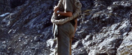
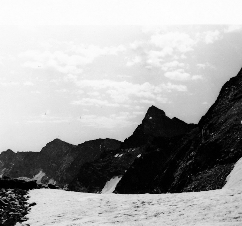
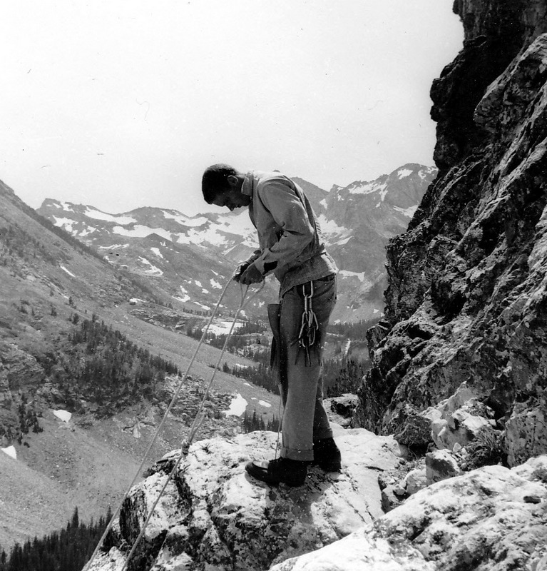
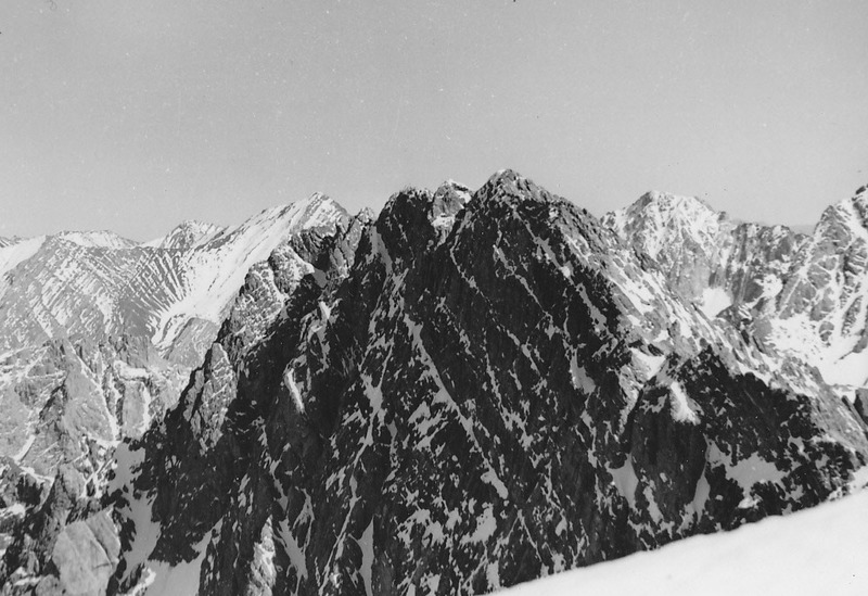
Evilio Echeverria was on a personal quest to explore the world when he arrived in Sun Valley from Chile in 1953. He took a job as a waiter at the lodge where he met Louis Stur. Stur quickly invited him into his climbing circle and the two shared many adventures over the next 3 years. The following photos were provided by Dr. Echevarria. The photos document a period during which written Idaho mountaineering history is hard to find. Dr. Echevarria contributed to the second edition of the book.
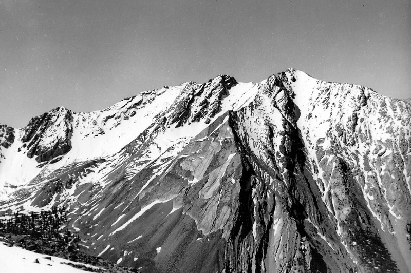
The North Ridge in front and the Northeast Face of Hyndman Peak. Evilio Echevarria PhotoHyndman Peak as viewed from the NNW. Evilio Echevarria PhotoApproaching the North Face of Hyndman Peak from Wildhorse Canyon. Evilio Echevarria PhotoThe North Face of Goat Mountain. Francis Willmarth of Berkeley, California. Evilio Echevarria PhotoOld Hyndman Peak as viewed from the north. Evilio Echevarria PhotoOld Hyndman Peak as viewed from Upper Wildhorse Creek. Evilio Echevarria PhotoThe WNW Side of Hyndman Peak. Evilio Echevarria PhotoFrancis Willmarth roping up on the North Face of Goat Mountain. Evilio Echevarria PhotoHyndman Peak and surrounding environs as viewed from the west. Evilio Echevarria PhotoOld Hyndman Peak as viewed from the north. Evilio Echevarria PhotoThe North Face of Leatherman Peak. Evilio Echevarria PhotoPeak 11090 as viewed from the summit of Mount Borah. Evilio Echevarria Photo
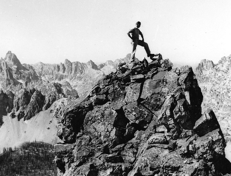
This is the summit ridge of what Louis Stur called Mount Hancher. [Editors Note: I am not sure which peak this is. The name has not stood the test of time]. Evilio Echevarria PhotoLouis Stur on the summit what he called Mount Hancher. [Editors Note: I am not sure which peak this is. The name has not stood the test of time]. Evilio Echevarria PhotoLouis Stur on the summit ridge of what he called Mount Hancher. [Editors Note: I am not sure which peak this is. The name has not stood the test of time]. Evilio Echevarria Photo
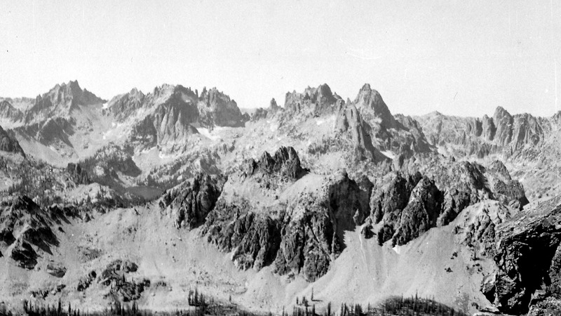
A panoramic view (left to right): Packrat Peak, Monte Verita and Warbonnett Peak. Evilio Echevarria PhotoLouis Stur ascending a slope in the Sawtooth Mountains. Evilio Echevarria PhotoLouis Stur and Freddi Haemisaeger on top of Horstman Peak in 1955. Evilio Echevarria PhotoLooking north from the summit ridge of Mount Bush during a solo attempt on the peak. Evilio Echevarria PhotoMount Bush as viewed from the northeast. Evilio Echevaria PhotoMount Bush as viewed from the west. Evilio Echevarria PhotoFrancis Willmarth surveying an approaching thunderstorm during a 1954 attempt on the North Face of Goat Mountain. Evilio Echevarria PhotoEvilio Echevarria during an attempt on the North Face of Goat Mountain. Evilio Echevarria PhotoThe final climb up Mount Borah as viewed from Chicken-Out Ridge in 1955. Evilio Echevarria Photo
First Ascent: Bob Boyles, Mike Weber and Curtis Olsen
Rating: Grade III, 5.8, A2
Description
Provided by Curtis Olson, Mountain Guides Inc., Boise, Idaho (as published in the American Alpine Journal, Idaho, 1983)
Mount Breitenbach, North Face, Lost River Range
From July 13 to 16, Bob Boyles, Mike Weber and I made the first ascent of the North Face of Mount Breitenbach. Bill March had told me that some years ago his party was turned back by very severe rock climbing at the top of a large couloir. We easily identified the couloir and rock band.
We also discovered a possible route to the west of that couloir but still east of the summit. We pieced our climb together. It consisted of small, steep snowfields intermixed with steep limestone. The crux was a short aid pitch next to a waterfall which led us into a 900-foot long, 10-15 foot-wide hairline couloir that we followed to a bivouac on the skyline just east of the summit. In the dawn, we descended the East-Northeast Ridge in 2 hours of Class 4 climbing.
On the second ascent of this route, Duane Monte and Kevin Sweigert bypassed the aid on the overhanging waterfall (A2) by using a free variation to the east (Class 5.8).
Photo Essay by Bob Boyles
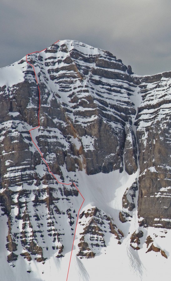
The North Face of Mount Breitenbach showing the Grand Chockstone Route. Wes Collins Photo
The Grand Chockstone Route on the North Face of Mount Breitenbach is shown above in red. There is a freestanding limestone stack about one-third of the way up the route where the route bends 90 degrees.
The stack. Curt Olson Photo
Amazingly, this stack appears to have survived the 1983 Borah Peak earthquake (magnitude 6.9) totally intact. This location is where the technical climbing begins.
Mike on the rock band pitch. Curt Olson Photo
This photo shows Mike on the rock band pitch between 2 hanging snow fields. All 3 of us rated this pitch as a dicey Class 5.8. And from this point on, retreat is not a very good option.
Mike topping out. Curt Olson Photo
Here, Mike is topping out at a marginal belay spot. Curt had 7 pieces of protection that consisted of copperheads and #1 and #2 stoppers strung together with equal tension slings on this belay. I clipped in and didn’t look at the anchors again until Mike finished this pitch. Faith be with us….
Mike on the traverse. Curt Olson Photo
This photo shows Mike traversing one of the hanging snowfields to the waterfall pitch.
Editor’s Note: Carl Hamke and Judi Steciak recently became the third and fourth climbers to summit all of Idaho’s peaks exceeding 11,000 feet. George Reinier and Johnny Roache were the first climbers to summit all of these peaks, while Judi is the first woman to accomplish this exceedingly difficult task. The short article below summarizes their quest and lists the 11,000-foot peaks that are not set forth in the book. The peaks identified below and the routes climbed by Judi and Carl were added to this site courtesy of Carl and Judi. Enjoy!
Tom Lopez’s guidebook for exploring Idaho mountains hits a good balance between detailed directions to trailheads and route descriptions that allow you to enjoy the thrill of discovery. Although many hundreds of mountains are included, peakbaggers wanting to summit Idaho’s highest mountains might be interested in learning more about the 17 ranked summits between 11,000-11,999 feet that are missing from the 2nd edition, plus a few easier routes on the Eleveners that are in the book.
It only fair to give a hint of the effort involved in summitting all 114 Eleveners. The peaks are spread out over 4 counties (Beaverhead, Blaine, Custer and Lemhi) and 7 different mountain ranges [Lost River (41), Pioneer (30), Boulder (17), Lemhi (9), White Cloud (8), White Knob (5) and Beaverhead (4)]. Most of the peaks are hikes or scrambles, but 10 have Class 4 routes and one has no other option than a Class 5 route.
In the process of reaching all those summits, we accumulated approximately 374,000 feet of elevation gain. This includes the 11,000 vertical feet we gained in one 2-day weekend (we were younger then). Note that the route from the Khumba base camp to the summit of Mount Everest shares the same elevation gain, albeit with higher starting and ending elevations. We covered at least 820 miles on the ground and spent at least 800 hours walking. You do the arithmetic: that’s only about a 1 mile/hour average. We found 23 peaks and/or routes for which we had no hard-copy information.
It took us 16 years from start to finish (along with many other higher and lower summits as well as ski trips, white water rafting…). We climbed as many as 3 Eleveners in one day. We needed 3 tries to summit some of the peaks, due to thunderstorms, wildfire smoke and not having the right gear in one case. We had to climb one Twelver twice in one day to reach an Elevener. We found no peaks with maintained trails to their summits. Trailheads were lonely places. We never met anyone on a summit and rarely met anyone in the valleys. We became addicted to the joy of exploration and discovery, and enchanted by the solitude, wildlife, wildflowers, pristine wilderness, and achingly beautiful vistas. Beware!
They say that one person’s junk is another’s treasure. Archeologists of future millennia should have a field day sifting through the midden of our modern society. Humans seem to leave calling cards wherever they go. Here are some Idaho mountain summit artifacts left by those of two or three generations back.
Left to Right (pictured):
WHISKEY PEAK (11,154 feet, Boulder Mountains). This pre-Prohibition whiskey bottle was left by some reveler high on this mountain. The summit view is north to Castle Peak (September 1993).
LEATHERMAN PEAK (12,228 feet, Lost River Range). The coffee can worked well to house a summit register until it rusted out. This one may have been placed by William McIntyre of Twin Falls in the mid 1950s….and look at that wooden ice axe! View north to Borah Peak (September 1984).
HOODOO PEAK/WCP-3 (10,588 feet, White Cloud Peaks). This summit sardine can dates from the early 1960s (October 2004).
Since the beer can’s introduction in 1935, mountains have provided an
artistic theme. The draw seemed to be recreation and pure water. Here
are some brands from the 1930s to the 1950s featuring Western U.S.
mountains.
Cone tops (shown on the top row) are sought-after items by collectors. Bohemian Club, brewed in Boise, was a favorite of WWII era beer drinkers. Tons of these could once be found in the Mount McCaleb dump (Mackay). The Sun Valley can (brewed in Pocatello) is rare. But keep exploring. You never know what’s over the next hill.
All material courtesy of Rick Baugher (April 23, 2007).