Editor’s Note: Sawtooth Mountaineering was Boise’s first climbing shop. It was founded by Lou and Frank Florence. The shop was an important link between many of Idaho’s premier climbers and the development of Idaho’s technical climbing scene. Bob Boyles (quoted on Page 23 of the book) noted the shop’s importance as a hub for local climbers, stating “The thirty or so most dedicated climbers in the Boise Valley often hung out at Sawtooth Mountaineering to share stories . . ..” This group of climbers, centered on the shop, are credited with some of the most challenging first ascents in Idaho. In this article, Frank recounts his and the shop’s history.
I grew up on Long Island (New York), hardly a mountainous setting. My early camping and hiking trips were in the Appalachian and Adirondack Mountains and I was introduced to mountaineering in 1970 as a student in NOLS. I stayed on with NOLS, eventually working as a course instructor in Wyoming and Washington State.
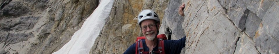
Bob Boyles and Lou and Frank Florence on the summit of Grand Teton. Mike Weber Photo
In 1972, I joined my father, Lou Florence, in bringing a small outdoor recreation equipment store to Boise. Our business (Sawtooth Mountaineering) promoted climbing, hiking, and cross-country skiing across Southern Idaho, from Slick Rock to the Lost River Range. We offered introductory climbing classes and fostered enthusiasm for climbing by hosting a speaker series with some of the leading climbers and alpinists of the day, including Royal Robbins, Henry Barber, Doug Scott, Bill March, and Sawtooth pioneer Louis Stur.
British Mountaineer Doug Scott lectured twice at our shop. The first time was in 1975. Scott came to Boise to give a talk about his recent ascent of the Southwest Face of Everest. He wanted to get in some climbing while in town and a posse quickly assembled. We went out to the Black Cliffs for what turned out to be a toasty day. Scott asked what had been done and what hadn’t and then led through a couple of each.
Scott came through Boise again in 1977 to give a slide show at the shop after his epic descent off The Ogre. And again I and a few others got a chance to climb with a famous alpinist. That time we returned to the Cliffs and he led what is now called the Doug Scott Route. Nice route, too. I remember Scott stopped at one point after trying a move and then pondered it a bit before he led through the sequence. When he came down, I asked him what he thought about it, especially that one section. “It’s all there,” he replied. “Just a lack of balls.”
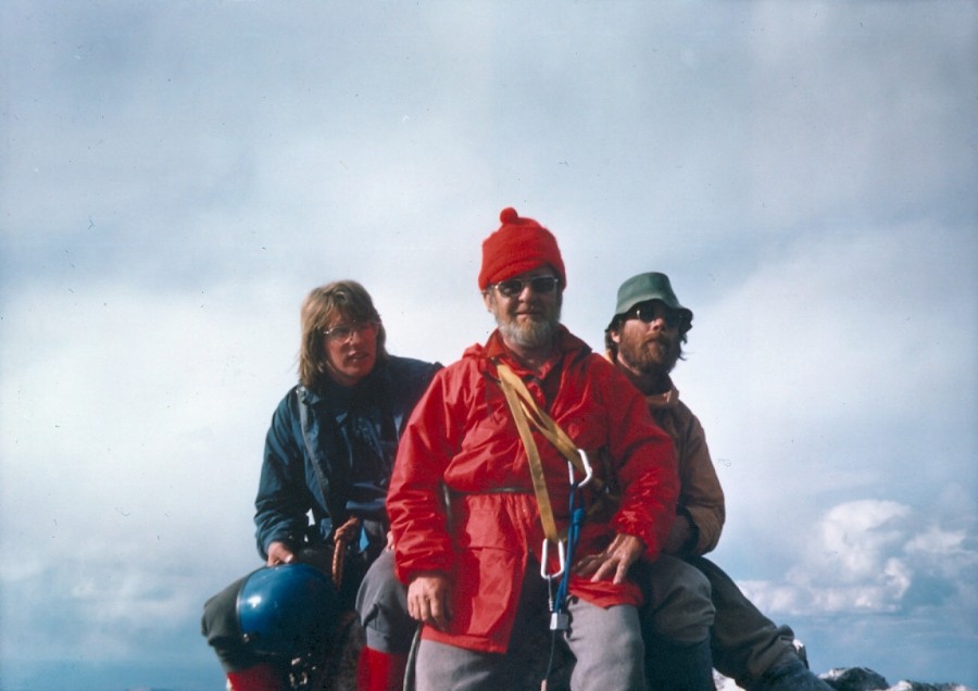
Doug Scott at the Black Cliffs (1975). Left to right Bob Boyles, Bob Henry, Doug Scott and myself. Lou Florence Photo
Through Sawtooth Mountaineering, we conducted popular introductory clinics in cross-country skiing and helped develop an early network of ski trails around Idaho City. Long-time staff members Ray York and Gary Smith, as well as Lou and I, trained and volunteered with Idaho Mountain Search and Rescue. Days off were spent exploring the many crags local to Boise: Stack Rock, Slick Rock, Table Rock, Rocky Canyon, Morse Mountain and the Black Cliffs.
I frequently partnered with Bob Boyles and Mike Weber on technical climbs, but in the mid 1970s, there was a free-wheeling mix of local climbers who swapped leads including Tom McLeod, John Platt, Art Troutner and Charley Crist. It was a time of discovery as there was little in the way of guide books and, championing clean climbing ethics, we clanged our way up the cliffs using hexes and stoppers. We became better climbers as we challenged one another on new routes locally and expanded our alpine skills into the Sawooths and Lost River Range. In the Winter of 1974, John Platt, Jerry Osborn, Walt Smith, and I skied across the White Cloud Mountains from Obsidan to Robinson Bar. In 1976, I summitted Denali with friends from Seattle and the following year made the first Winter ascent of Mount Borah’s North Face with Art Troutner, Mike Weber and Bob Boyles.
Sawtooth Mountaineering closed in 1980 and I returned to college and a career in geology. That took me out of Boise but, from time to time over the years, it’s been my pleasure to renew my acquaintance with the Sawtooths and the Lost River Range and those same partners from back in the day.
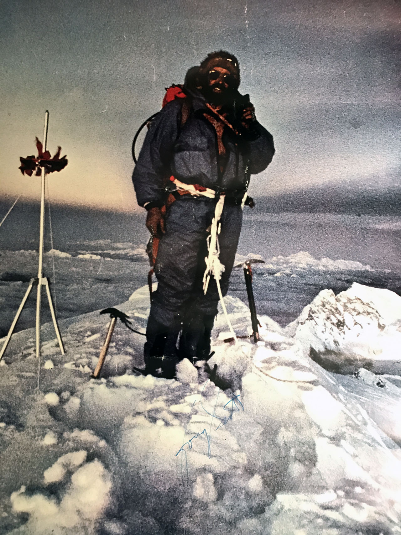
During one of Doug Scott’s lectures at Sawtooth Mountaineering, Bob Boyles secured a signed copy of the famous climber’s posters.
Idaho is a virtual sea of mountains. While there is no doubt that Native Americans rambled across the state’s mountain summits and that explorers, trappers, miners, ranchers, surveyors and locals were climbing Idaho’s mountains from the time Lewis and Clark first passed through the state, there are few recorded accounts of these early ascents.
When I wrote Idaho: A Climbing Guide, I noted at the time the second edition was published that “The following [Climbing History] is a thumbnail sketch of Idaho’s mountaineering history, filled with unfortunate, but unavoidable gaps.” In the intervening years, I have searched for additional accounts of Idaho climbers to fill in the gaps. I recently came across a couple of 92-year-old Idaho Statesman articles that answered one of my unanswered questions about the Sawtooth Range.
The birth of modern Idaho Sawtooth mountaineering has historically been credited to Robert and Miriam Underhill. Robert, a Harvard philosophy professor and an Appalachian Mountain Club member, was a cutting edge American mountaineer in the 1920s and 1930s. Miriam was the top American female climber of her time. They climbed in the Sawtooths in 1934 and 1935 and then published articles in the Appalachian Mountain Club’s journal, Appalachia, in 1934 and 1935. No doubt, these articles awakened the wider climbing community to the Sawtooth’s impressive granite peaks but who told the Underhills about the Sawtooths?
The Idaho Department of Commerce publicized the scenic beauty of the Sawtooths as early as 1910. However, it is unlikely that the Underhills read about Sawtooth climbing opportunities in an Idaho Department of Commerce brochure or in Idaho Statesman articles, like the the 1927 article “Crown of the Sawtooths” by Bob “Two Gun” Limbert.
It turns out that the link between the Underhills and Idaho was Norman Clyde. Norman Clyde (1885-1972) was unquestionably one of the most prolific Sierra Nevada explorers and climbers. He is credited with more than 130 first ascents in the Sierra, has a peak, a minaret and many routes named after him. Less well known are Clyde’s climbing adventures in Montana, Wyoming and Idaho. Yes, Idaho. Although a very obscure fact, in 1927, Clyde climbed in both the Sawtooth Range and the White Clouds.
Clyde was also a prolific writer. The Bancroft Library at the University of California maintains Clyde’s papers which includes an archive of 1,467 articles. Three of these articles cover Clyde’s visit to Idaho in 1927: An Ascent of Castle Peak; Up and Down Castle Peak; and A Glimpse of the Sawtooth Mountains of Central Idaho. Two of these articles, An Ascent of Castle Peak and A Glimpse of the Sawtooth Mountains of Central Idaho (albeit with a slightly altered form) were published in the Idaho Statesman in 1929.
Clyde’s visit to Idaho was first noted in a September 10, 1927 news clip in the Idaho Statesman:
“CLIMBS SAWTOOTH PEAKS”
HAILEY — Norman Clyde, who makes a specialty of guiding parties on mountain climbs, is in the Sawtooth country looking for new territory and has finished climbing a number of the major Sawtooth peaks, including some of the White Cloud peaks and Castle Peak. He reports that Castle Peak is not so hard to climb as the Grand Teton, where he conducted a party last year, but is a mountain that will appeal to mountain climbers. Mr. Clyde’s home is at Independence, California.”
The first Clyde article published by the Statesman was a shortened version of his longer, unpublished article, A Glimpse of the Sawtooth Mountains of Central Idaho. The Statesman article was entitled A Southerner’s Glimpse of the Sawtooth Mountains. It appeared on June 2, 1929. This article recounted his ascent of Decker Peak and described the rugged crest.
“Arriving at the crest of the ridge, I came upon a trail leading toward the summit of the range. This I followed until it terminated near timber line. To the southwest, beyond rocky cirques, the summit of Mount Decker came into view. Here it was necessary to drop down several hundred feet in order to avoid an impassable crag.”
Despite suffering from a violent toothache, Clyde pressed on. He recounted:
“As I advanced, more and more of the rugged crest of the range came into view. After surmounting several craggy and glaciated pitches, I reached a talus slope just below the summit. Seized with the elan that fills me when nearing the summit of a mountain, I soon traversed this and scrambled up to the crest of a narrow arete which I followed to the highest point of the peak.”
Clyde then described the view in terms that make climbers grab their packs and head for the mountains:
“The panorama that lay outspread around me was thrilling. For a score of miles in either direction extended the crest of the Sawtooths—a maze of craggy peaks, deep cirques, narrow ridges and pinnacled knife-edges. Azure lakes lay ensconced in verdant timbered bowls of the lower basins while others lurked in rocky cirques, tinged with a shade of turquoise; one with an indescribable amethystine hue. Masses of snow clung here and there to precipitous slopes, while several remnants of almost vanished glaciers appeared in sheltered depressions. Fleecy clouds floated slowly past, crossed the Sawtooth Valley and gathered about Castle peak and the White Cloud peaks. In every direction, range after range extended to the horizon. To the north, the broken crest of the Sawtooths continued for a considerable distance. To the southeast, undulating lines varied by several precipitous mountains faded away in the distance. To the east, beyond the Sawtooths were the high masses of the Boulder and Hyndman groups .”
The second of Clyde’s three Idaho articles, An Ascent of Castle Peak, was published in the Idaho Statesman on June 9, 1929. His article doesn’t mention if he found evidence of a previous ascent but does constitute the earliest description of a climb of the White Cloud Peaks giant.
Clyde made his base camp for his Idaho explorations at the F.W Shaw Ranch near Obsidian. He undoubtedly learned about the lay of the land from his hosts. Following, this advice, he approached Castle Peak via Fourth of July Creek. He climbed an unnamed peak along the way, probably the still unnamed Peak 10405, and then made his way of into Chamberlain Basin and the lake below Castle Peak’s South Face. The next day he climbed up the face, writing:
“Leaving camp early on the following morning, I was soon trudging up the steep slope that rises to the east of the lake to an elevation of about 1,500 feet above it. As I surmounted it, I came into full view of Castle Peak, towering above a lake-studded basin a few hundred feet below me. A number of steep chutes seemed to rise almost vertically toward its summit, which appeared to consist of a series of pinnacles of almost equal height. One chimney, just to the left of the summit almost reached it but, as the apparently perpendicular wall above it appeared to possess few holds, I decided to go to the east and ascend its Southwest Shoulder or attempt to find a way up–another.”
His account into the unknown continued:
“. . . Crossing above one of them, I made my way up a a broad stretch of talus and then up a chute, broad and gently sloping at first, but soon narrow and steep. After reaching its head by a somewhat difficult scramble, I crossed one narrow arete to another and went toward what appeared to be the summit, but upon reaching it I found it to be only a point on a jagged knife-edge, with another higher one to the east, beyond a deep gash in the arete. Dropping down several hundred feet, I quickly climbed to the top of it. Probably the highest point on the mountain, but several pinnacles of almost equal or possibly greater height were seen to the east. . . .”
Thus, Clyde was confronted with the same question that still confounds climbers 92 years later: which point on Castle Peak’s ragged summit ridge is the true summit? He continued:
“To make certain of not missing the highest point of the mountain, I proceeded to climb the other pinnacles. As I worked my way along the cliff, surmounting one after another of them, I found interesting but not very hazardous climbing, except possibly in one instance where I carelessly stepped on a loose mass of rock that suddenly gave way. Fortunately I had a good handhold, and after hanging in partial suspension for a few moments I was able to proceed along a narrow shelf. Eventually I came to the last of the higher pinnacles.”
No doubt the Idaho Statesman’s publishing of Clyde’s articles and similar articles gave local climbers further reason to explore the Idaho mountains. How did Clyde inspire the Underhills to travel form their home at Harvard to Idaho?
Clyde was a member of the Sierra Club. In 1931, Sierra Club officer Francis Farquhar invited Robert Underhill to the Sierra Nevada to teach the latest techniques of roped climbing to Sierra Club members. Clyde was part of this group. Given Underhill’s drive to explore mountains world wide, there can be no doubt that he and Clyde exchanged climbing stories over a campfire.
The link between Clyde and the Underhills led to the opening of the Sawtooth Range to a cosmopolitan, out of state, array of climbers including Fred Beckey, Luis Stur, Gordon Webster, Steve Roper, Bill March, Jeff Lowe and the Iowa Mountaineers. Idaho climbers followed these climbers and established themselves in the Pantheon of Sawtooth Climbers. Lyman Dye started the first Sawtooth climbing guide service and he was later followed by Kirk Bachman who established Sawtooth Mountain Guides. Reid Dawdle, Ray Brooks, Dave Bingham, Kevin Swigert, Jeff and Kelly Rhoads and many others redefined and refined the Sawtooth climbing ethic which started with Norman Clyde’s 1927 visit.
[Editor’s note: J.D. Martin was an early settler of the Lost River Valley. As he was nearing his 90th year, he wrote a memoir covering the early history of the Lost River area which was published in installments in the Arco Advertiser. This portion covers his ascent of Mount McCaleb in 1884. It also references other ascents of mountains in the Lemhi Range near Badger Creek but does not supply names. Badger Creek is located just below Diamond Peak. Martin’s obituary is set out below his trip report.]
. . . From there we went on to Badger Creek where a number of mining locations had already been made. We climbed several mountains around there but could find nothing which incited us to remain very long. We took another trail, over what was also then called Pass Creek and came onto Birch Creek, a few miles below where the old-time ghost town of Nicholia was at that time quite a bustling and busy little mining town.
A smelter was in operation and a population of perhaps two hundred people were living there. We then went on over the divide to another old time “ghost town” called Junction which was located on the east site of the Lemhi River about a mile from where the town of Leadore now is. This was also quite a bustling and active little town for that time and place. From there, we went on over the [Beaverhead] Range on the East Side of the Lemhis and prospected along the dividing line of the two territories of Idaho and Montana.
We found nothing which we deemed worth locating and returned soon to Junction. We then concluded to go up the stream, then and now called Timber Creek, which comes into the Lemhis about a mile or so below Leadore. We endeavored to simply “course our way” without trails or guidance of any kind, relying solely upon our sense of direction. Wild game was so plentiful that we could in a few minutes after pitching camp, easily kill all the wild birds we wanted to eat. An abundance of the three camp essentials (wood, water and grass) were everywhere and we were well inured to outdoor and camp life.
In passing around the divide between the headwaters of the Little Lost River and the Pahsimeroi, we somehow got onto a blind Indian trail which led us to a point and in a direction somewhat too far north. We came to a place where the higher mountains in front of us seemed to offer an impassible barrier to our further progress in the direction we were going. We found a good camping place for the night and were considering plans for retracing our steps next day. Next morning, Mr. Soloman was not feeling well and proposed that we lay over a day. Williams had seen bear tracks and, taking his gun, started out to add to his hunting laurels by killing a bear.I took a prospector’s pole, pick and started to climb the rough and rugged mountain which stood directly in front of our camp.
After some hours of arduous and laborious climbing over fallen timber, rocky gorges and deep precipices, I arrived at the top. And behold I stood at the summit of Mount McCaleb. Well, lest this screed should exceed the limits of permissible space, I will here close with the promise that the next installment of this narrative will begin at the summit of Mount McCaleb. (ARCO, June 15, 1941)
From the summit of Mount McCaleb and the date of about the last of August 1884. I do not deem it necessary to attemptany kind of a detailed description of the view from the top of Mount McCaleb. I will say that, at that time, nothing contributed by human agency was visible from there. A long, winding fringe of deep green, reflected from the dense growth of trees which marked the course of Lost River (at that timefar more abundant and extensive in every way than it is now)was quite visible and marked the course of the valley from the extreme northwest to the southeast. Upon the whole, it was really a sight never to be forgotten and it has always been something of a wonder to me to find so many people who have never been to the top of Mount McCaleb. I returned to the camp and was able to inform my companions—Solomon and Williams—exactly where we were. . . .
J.D. Martin 1852 to 1942
“GRAND OLD MAN” OF BIG LOST RIVER VALLEY SUMMONED
Honorable James D. Martin Closes Career Tuesday Morning After Nearly 90 Years of Active and Honorable Life. [The Arco Advertiser April 17, 1942]
Judge James D. Martin, known as the “Grand Old Man” of the Lost River Valleys, came to the end of the long, long trail Tuesday morning. His nearly 90 active and honorable years–more than half of them spent in this valley–closed Tuesday morning, and with his death closes the career of a man who was very much a part of the life of our community.
He had been ill with a cold for several days, but he seemed somewhat improved when he retired Monday night. When he did not appear at his usual hour Tuesday morning, Mr. Daniels (hotel owner) went to the room where the lifeless body was found in bed. Only a short time before, Dr. Egbert said, had his spirit taken flight. Although he was known to be failing in health, the news of his demise spread to the remotest sections of our county and was a shock to all. There was a hushed silence as the death was announced because “Judge” Martin was known intimately by every man, woman and child in the Lost River country and to them he was both friend and counselor.
Judge Martin wasn’t just an ordinary individual. Although he left his native state of North Carolina when he was a lad of 17 and, as a consequence of which, his education was sadly neglected, he was a man of brilliant intellect–a self-educated man. He continued the quiet dignified bearing of his early youth to the very last. He wrote many interesting pioneer articles for The Advertiser in recent years and always took a leading part in community affairs.
Martin was born in North Wilkesboro, North Carolina in October 1852. At the age of 17, he and a boyhood chum left to cast their lot in the West. He followed the life of a nomad from then on for 15 years, spending time on the frontier in Colorado, Arizona, and California. In 1883, Martin was attracted to the Wood River country where a mining boom was underway and, naturally, he turned toward the Lost River Valley in 1884 as this valley was then attracting a great deal of attention.
He filed on a homestead in what is now the Lost River precinct in 1884. He lived there during the required length of time and, between times, worked in the mines on the Wood River. After proving up on his claim, he settled down and became a gentleman farmer in this valley. His education had been improved during his spare time, as he studied hard to increase his many abilities. He taught the second school of record in this valley, and spent a year or more in similar work in Little Lost River Valley. Many of our “old timers” gained the fundamentals of their schooling–their three “R’s”–in the little schools he taught.
Soon after the Lost River Valley began taking on airs as a “homeland,” he was elected Justice of the Peace. in this position, he served manyyears. He became a confident and legal assistant to many of our first families. He performed marriages, spoke at funerals, settled estates and, in scores of ways, endeared himself to the people of the valley.
He served in other official capacities also. he was County Commissioner during 1919 and for several years thereafter. The first highway construction work in this county—the road to Howe—was built and gravel surfaced during his administration. He was County Commissioner when the Irrigation District was formed. Later he retired as County Commissioner and served several terms as Probate Judge. He was always active in civic and fraternal affairs. He served as Treasurer of the Arco Lions Club during its existence. He “went through the chairs” in the Odd Fellows’ Lodge and for many years continued an active interest in that great fraternal organization. He made frequent trips to his old home in Wikesboro, North Carolina. He also visited a brother in Texas, who served many years as a district judge.
For quite a number of years, Judge Martin made his home at the Dee Hotel at Arco and, during most of this time, he served as chairman of the Butte County Red Cross, an organization of which he held the highest regard. The successful membership campaigns and other activities engaged in by this humanitarian organization were always a great delight to Judge Martin. He was generous and kind-hearted. He gave generously to charity. He was far from wealthy but, by frugal management and simple wants, he garnered enough of the world’s goods to maintain himself during the years in the sunset of his life.
Judge Martin seemed to feel that his days were numbered that when he was stricken with a cold about two weeks ago. He confided to friends that in all of his other illnesses he seemed to been able to overcome them, but on this occasion he told one intimate friend: “I feel that it is only a matter of time now, until I shall be called. I do not seem to be able to overcome this cough, but I am ready.” That was like him.
He united with the Unitarian church in his youth and, although he did not affiliate with any other, he was quite a regular attendant atservices in this community dividing his time between the Baptist and the L.D.S. churches. Funeral services will be conducted this afternoon from the L.D.S. church officiating. Funeral arrangements are in charge of the Marvel Funeral Home and interment will be at Hillcrest. Services will begin at 2:00PM and several of his intimate friendsare taking part in these rites. A nephew is expected to arrive from Texas. Thus a highly honored and respected citizen will remain with us in life.
Mountain climbers and obsessive peak-baggers have a common goal: to stand atop a specific mountain or series of mountains. It is generally accepted that you must stand on the highest point of a mountain to claim a successful ascent. Thankfully, about 95% of the time, there is no dispute as to the mountain top’s exact location (true summit) and its exact elevation (true elevation). But about 5% of the time, things can get murky. Sometimes the location of the true summit is in dispute; sometimes the true elevation (measured in either in feet or meters, or both) is in dispute. This essay attempts to isolate and address these two issues.
Where is the true summit and how is it determined?
To answer this question, we must examine several generic cases (with specific illustrations of Idaho Mountains when possible). We shall start with the easiest case and then progressively handle more complicated cases.
CASE #1
The easiest case is one in which there is one, and only one, highest point. It may be a measured point using a USGS topo map’s figure or it may be the area above the highest contour line on the map (an unmeasured summit). In the latter case, there is only one “highest contour line.” But even in this simple case, you may have to wander around on a summit plateau searching for the “highest point” (measured or unmeasured). Sometimes, it’s just not possible to locate a clear, highest point on a particularly flat summit area. In other instances, some kind soul has built a cairn at what they consider to be the “highest point” and your search is probably unnecessary. In other cases, a surveyor has left a USGS benchmark, or rebar stuck in the ground, or a large cairn with a post in it to indicate exactly where the elusive high point is.
CASE #2
This is the case where a mountain has two measured summits of exactly the same height. THIS IS EXTREMELY UNUSUAL. In Idaho, Peak 8297 fits the bill. This peak is located just off US-93, south of Challis, at Broken Wagon Creek Road. The peak has a narrow summit ridge that stretches from South to North and is over a mile in length. The North Summit is measured at 8,297 feet. The South Summit is measured at 8,297 feet. Which one is the true summit? BOTH ARE. A true peak-bagger will climb both summits to claim this mountain. Doing only one isn’t enough. Why didn’t you climb the other one?
CASE #3
This is the most deceptive case. It is a case in which a measured summit appears to be the true summit, but isn’t. There is an unmeasured summit nearby that sits above a higher contour line than the measured summit. When climbing obscure mountain peaks in Idaho, this case occurs with a much greater frequency than you would think. If you simply look at the USGS topo map, you will be lured into believing that the measured summit IS the true summit.
It is only when you look at the map more closely (or consult an authoritative source on the location and elevation of the true summit of that mountain peak) that you realize that the measured summit is NOT the true summit. The [nearby] unmeasured summit is undeniably higher in elevation (thanks to the higher contour line) and is the true summit. Another way that you will stumble upon Case #3 is when you consult a respected source for peak information and are puzzled as to how they arrived at an elevation for the peak that doesn’t coincide with the measured elevation.
For example, let’s say we have a peak that has a measured summit of 9,995 feet. But your favorite source for peak information lists the peak’s elevation at 10,020 feet. What’s going on here? You examine your source’s map showing the true summit and it turns out to be an unmeasured area above a contour line. In this case, that contour line is at 10,000 feet. The true summit in this case is between 10,000 feet and 10,039 feet (assuming a 40-foot contour interval). Typically, the respected source will use an interpolated estimated of 10,020 feet. 10,020 feet beats 9,995 feet every time. Even if we assume that the unmeasured summit is only 10,000 feet, it still wins and is correctly awarded the honor of being the true summit for this mountain peak. The measured summit of 9,995 feet sits above a [lower] contour line at 9,960 feet.
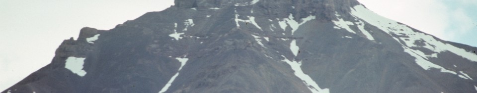
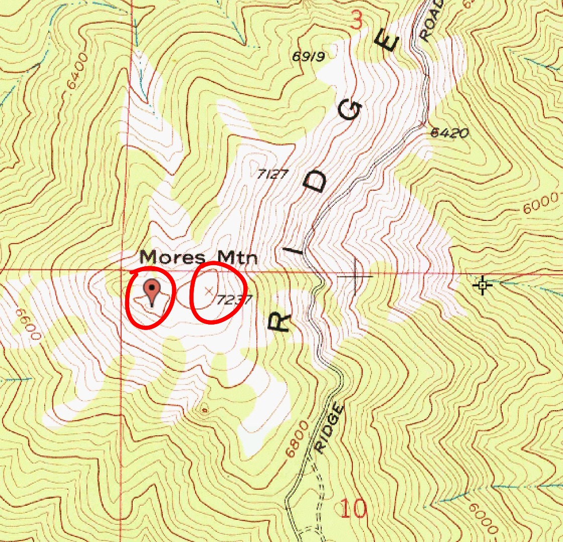
Here is an Idaho illustration of Case #3. Mores Mountain has an elevation of 7,260 feet and yet the nearby measured summit is 7,237 feet. The higher summit is to the west of Point 7237, but a quick look at the map might fool you into thinking that the elevation of Mores Mountain is 7,237 feet. Page 144 of the book incorrectly shows the elevation of Mores Mountain as 7,237 feet. The true summit is just west of Point 7237 and has a higher contour line than Point 7237. The true summit is measured at 7240+ feet or an interpolated elevation of 7,260 feet.
Be VERY CAREFUL when consulting your map(s) to not make the mistake of bagging the [lower] measured false summit. It is remarkably easy to do because the difference between the measured summit elevation and the “highest” contour line might be slim. And if the two points are separated by enough distance, your visual inspection (if you even do one) might just deceive you. This is a case where a respected authority on determining true summits and true elevations is INVALUABLE. I’m not going to name names, but there is one source in particular that is astonishingly good at determining the true summits of thousands of Idaho’s mountains. It’s really amazing.
CASE #4
This is the case where a mountain has two (or more) unmeasured summits of equal height. An unmeasured summit is one that lacks a specific elevation. It is considered the true summit if it is located above the highest contour line for that mountain. But, in Case #4, we have two (or more) possible true summits since we have two (or more) independent, “highest” contour lines of equal height. In this case, we simply don’t know which one is highest. You must stand on each potential summit and make your own determination—visually or, preferably, with the assistance of a GPS or Altimeter reading. Simply assuming that the “highest” contour line with the greatest land area above the contour line is the true summit is a logical, but not sufficient, assessment.
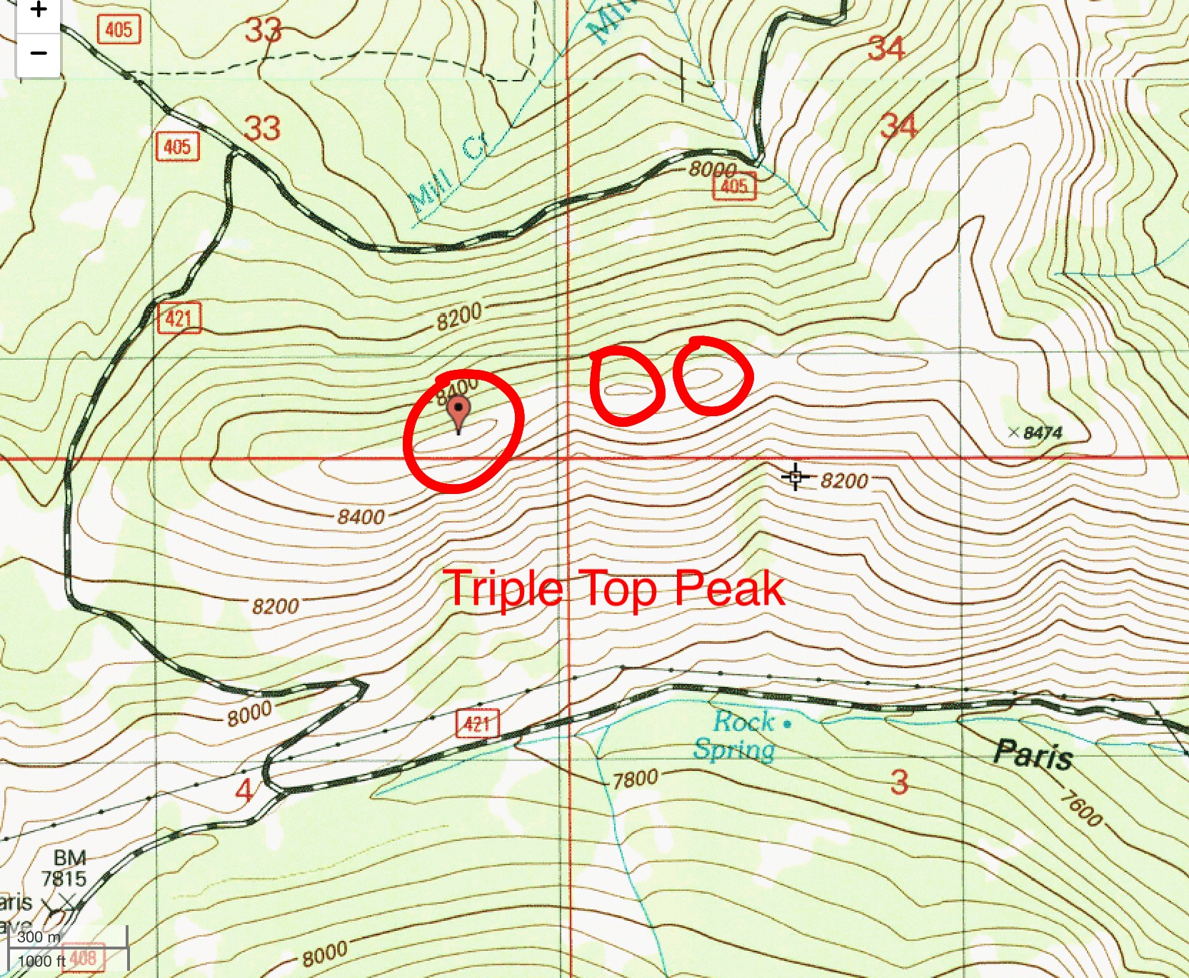
The closer the potential summits, the easier it is to make a subjective assessment. The farther apart the potential summits (and/or the larger the number of potential summits), the more difficult it is to make such an assessment. Tom Lopez made such an assessment on Idaho’s Triple Peak. I made such assessments on both Triple Top Peak and North Sister. In the case of Triple Peak, the contour line with the largest land area above the “highest” contour line is the true summit. However, in the case of Triple Top Peak, the contour line with the largest land mass above the contour line is NOT the true summit. In the case of North Sister (a peak with four potential summits), it was a tie between the third and fourth summits, both of which have similar land area above the “highest” contour line.
The map only creates a question as to which is the highest point on this peak.
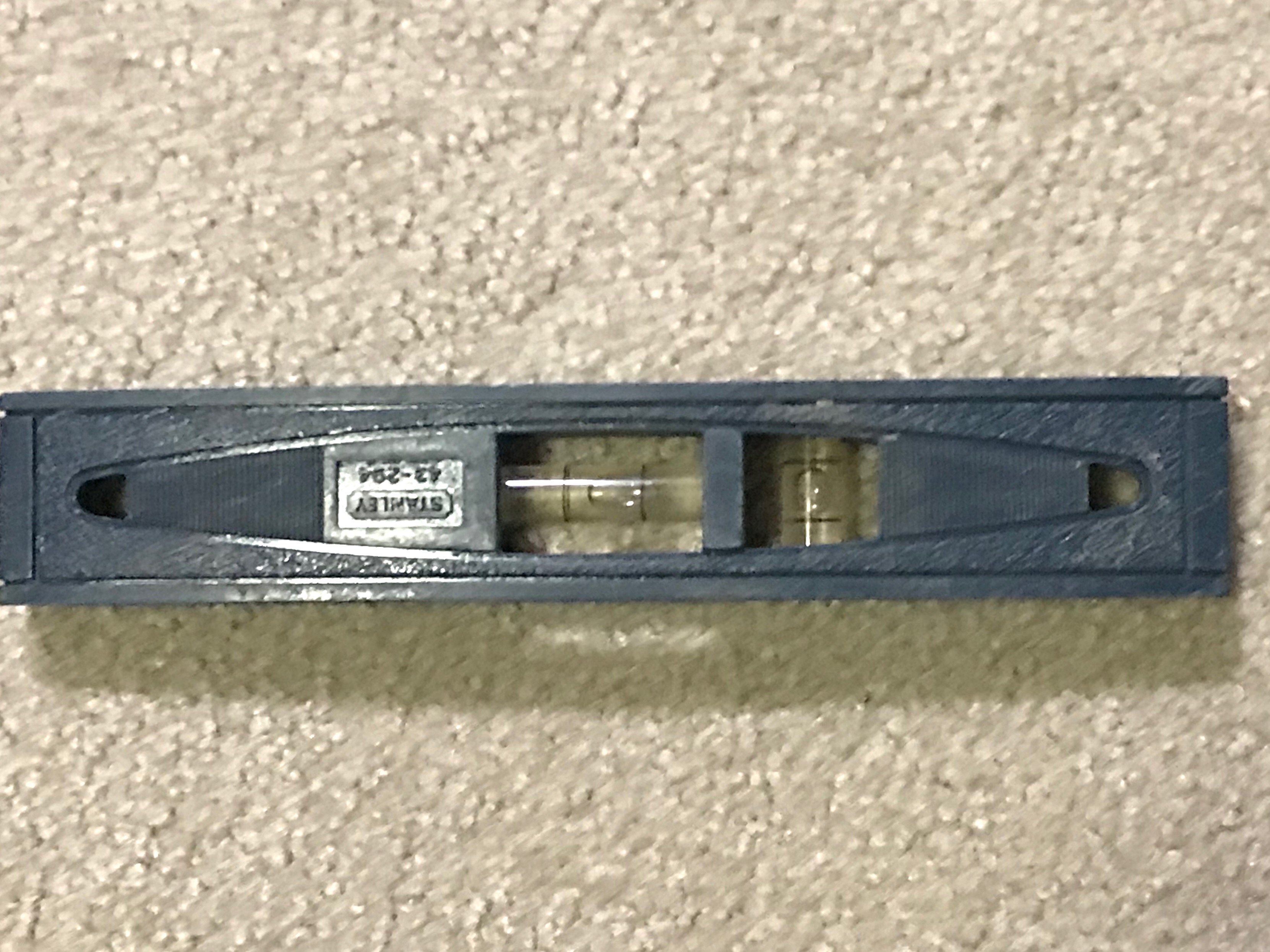
As you can see, determining the true summit can be a tricky endeavor. The best advice is to stand atop all of the potential summits, if possible, just to be sure. If the potential summits are close to each other and you can make a visual determination then a visit to each high point seems unnecessary. A small plastic hand level is an essential tool when the highest point is in question. [The following link discusses the use of a hand level in detail: Tips & Techniques for County Highpointing with Hand Levels]
This level only weighs a few onces and is easy to carry in your summit pack.
CASE #5
This is the case where a mountain has a measured summit and two (or more) unmeasured summits and all of the aforementioned summits share the same, albeit independent, “highest” contour line. This case raises the most complicated and contentious debate. And, unfortunately, it occurs more often than you would think. In Idaho, illustrations include Kinport Peak and Oxford Peak. The easiest way (and the traditional way) of handling these cases is to simply go with the measured summit and ignore the unmeasured summit(s).
Problems arise when you give the unmeasured summit an exact altitude (typically an interpolation between the “highest” contour line and the next higher contour line). An interpolation is simply the mid-point between the “highest” contour line and the next higher contour line. Contour intervals are typically 40 feet but are sometimes 20 feet (with low elevation peaks) and can be measured in meters as well (typically 20 meters, but sometimes 10 meters). An interpolation is simply an estimate. It is not an exact measurement.
Let’s say that we have a peak with a measured summit of 10,415 feet. The highest contour line for this measured summit is 10,400 feet. We also have an unmeasured summit that shares the same, but independent, contour line at 10,400 feet. Tradition says the true summit is located at the measured summit of 10,415 feet. However, some will assign the unmeasured summit an altitude of 10,420 feet (an interpolation based on a 40-foot contour interval). Comparing the 10,420 altitude to the 10,415 altitude, the unmeasured summit wins and is consecrated as the true summit.
But all we know about the unmeasured summit is that it is somewhere in the 10,400 to 10,439-foot range. We simply don’t know its exact elevation. Is it higher or lower than the 10,415-foot measured summit? We just don’t know. We can, however, do a visual inspection of our own, preferably backed up by a GPS or Altimeter measurement of each summit. From that inspection, we can then subjectively determine the true summit. When you mix interpolations (estimates) with actual measurements, the actual measured summit is thrown by the wayside about half of the time. The other half of the time, the measured summit wins. It’s really a crap-shoot. It’s better to either accept the measured summit as the high point (tradition) or to do a subjective, ON SITE assessment.
CASE #6
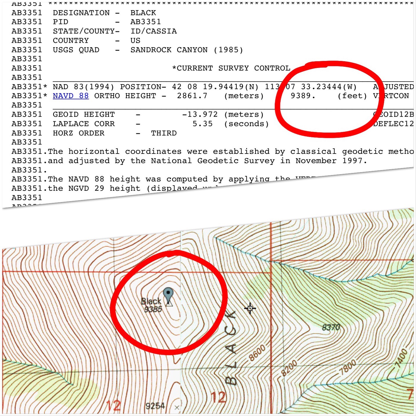
This is the case where a mountain has a measured summit but has a higher, unmeasured point that shares the SAME, NON-INDEPENDENT, “highest” contour line. In Idaho, such is the case with Black Peak/Black BM (in the Black Pine Mountains) and Wet Peak (in the Lost River Range). In each of these instances, the true summit is not the USGS benchmark (the measured summit) but is a higher point about 100-150 horizontal feet away. The higher point measures at 10 vertical feet higher than the BM in both of these cases.
Tradition dictates to ignore the unmeasured summit and go with the measured summit. Visual, ON SITE inspection may very well warrant a subjective assessment that the nearby unmeasured summit is somewhat higher. Indeed, on Page 351 of Idaho A Climbing Guide, Black Peak is assigned an elevation of 9,395 feet, 10 feet higher than Black BM (9,385 feet) because of observations of climbers who have done their own ON SITE inspection. I concur with that subjective assessment as I did both a visual and altimeter-based assessment of the two humps. My Altimeter determined Black Peak to be 10 feet higher than the nearby Black BM location (the altimeter measures altitude in 5-foot increments).
Once again, your safest bet as a mountain climber/peak-bagger is to stand atop both the measured summit and the unmeasured summit, JUST TO BE SURE. In Case #6, they are likely to be located fairly close to each other, making for an easy assessment. It is a subjective assessment, however. Sources considered to be reliable/authoritative still rely on the measured summit’s altitude, AS THEY SHOULD.
Case #7
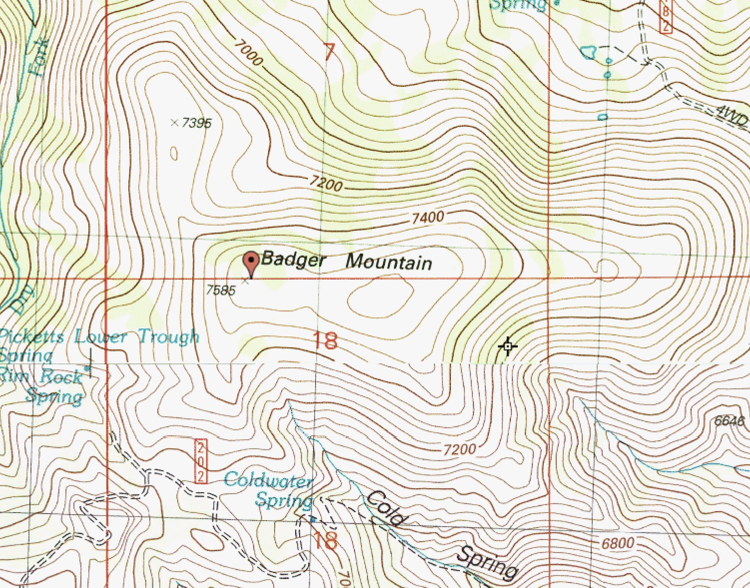
This is the case where there is uncertainty about the location of a summit because of an inconsistency in the USGS topo map measurements. Let’s look at Badger Mountain in the South Hills of Idaho:
The measured elevation for Badger Mountain is 7,585 feet. The summit is located at the western end of a wide summit plateau. However, the eastern end of the summit area is on a higher contour line (7,560 feet) than the western end (7,520 feet). How can this be? Did the USGS mapmakers intend to place the measured point at the eastern end, above the 7,560-foot contour line? Or did they forget to include a 7,560-foot contour line at the western end? Or is the 7,585-foot figure a mis-measurement?
Where is the actual high point for Badger Mountain? Based on the contour lines, the western end is lower than the eastern end and can’t possibly have the summit high point there. The eastern end has a higher contour line but a lower interpolated elevation (7,580 feet) than the specific point measurement at the western end (7,585 feet). This is all very confusing thanks to inconsistent map representations on the USGS topo map. I stood on the eastern end of Badger Mountain and, as the contour lines indicate, the high point is there. It is visually obvious and there is a summit cairn there as well. In cases like this, you must investigate the summit area for yourself and make your own determination of the location of the high point, ignoring the USGS topo map’s inconsistencies.
What is the true elevation of a summit and how is it determined?
There are two types of true elevations: actual/measured ones and estimated/unmeasured ones. We will discuss each in turn.
Actual/measured summits
In the process of mapping the Western United States, many mountains were measured by the intrepid surveyors working as part of a U.S. Government-funded project. In more recent times, the United States Geological Survey (USGS) has placed specific altitudes on many mountain peaks as well as USGS benchmarks. Periodically, these altitude assessments are updated, as can be seen with a comparison of an [older] 15-minute USGS topo map to a [more recent] 7.5-minute USGS topo map. Tradition is to ascribe the most recent altitude measurement to be the correct one. If an altitude is no longer given on the latest 7.5-minute map, then the [older] 15-minute map assessment is used. In addition, some sources use North America Vertical Datum of 1988 (NAVD88) measurements as a supplement to the [older] USGS topo map measurements.
Regrettably, there are inconsistencies found on USGS maps, data sheets/maps and BGN pages. Here are two examples:
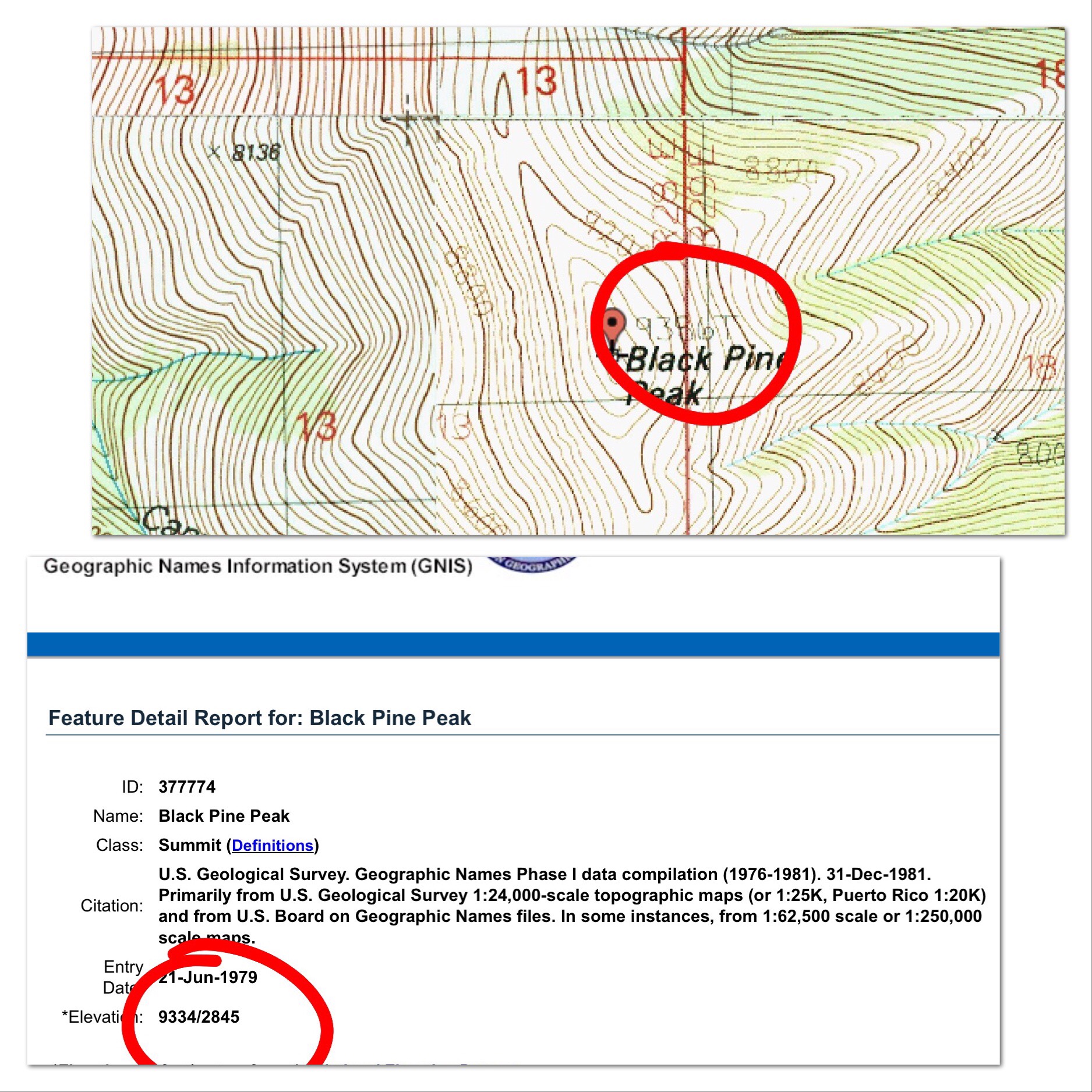
This graphic shows the discrepancy between a USGS map and the underlying data sheet for the Black Benchmark in Idaho’s Black Pine Mountains..This graphic shows discrepancy between a USGS map and the associated Board of Geographic Names page for Black Pine Peak in the Black Pine Mountains..
In most cases, minor changes (or inconsistencies) in measured altitudes are not terribly important. It can become an issue, however, when comparing two summits of similar height (e.g., Black Pine Peak versus Black Peak/BM) where one peak is a ranked summit and the other is an unranked summit. But, thankfully, that situation is not common. Given the GPS technology that we now have (and perhaps more accurate surveying equipment for ON THE GROUND work), we will probably see some adjustments to specific altitude measurements in the future. And, generally speaking, it’s not a big deal.
Estimated/unmeasured summits
It’s really astonishing how many mountain points and peaks have specific altitude measurements. However, many of the more obscure Idaho peaks lack a specific altitude figure. In these cases, sources rely on the highest contour line as the starting point to make an assessment of a specific altitude for a mountain peak. Typically, an interpolation is used as the specific measure of a peak’s altitude. For example, a peak with a “highest” contour line of 10,400 feet is assigned an altitude of 10,420 feet (assuming a 40-foot contour interval). And, with nothing else to rely on but a topo map with contour lines, such an interpolation is a reasonable estimate. It’s probably more logical than any other estimate. And it’s better than using an ill-defined figure like “10,000+ feet.”
Problems arise when you have a mountain with multiple potential summits (Case #5), one of which is a measured summit. Tradition says to use the measured summit’s altitude and ignore the unmeasured summits entirely. Sources considered to be reliable/authoritative either go with tradition or use the higher of the interpolation and the measured altitude. Others rely on climbers’ ON SITE evaluations.
Given the rather arbitrary nature of comparing interpolations/estimates to actual measured altitudes, I side with tradition on this one. But an ON SITE inspection is not a bad thing. I do it all the time. If you are a purist mountain climber/peak-bagger as I am, you simply must stand on all of the potential high points and make your own determination, if for no other reason than you wish to honestly say that that you stood on the highest point. In cases where a nearby summit is visually [and obviously] lower in altitude, I see no need to stand on the lower summit(s).
That being said, when I stood on the [higher] unmeasured south summit of Kinport Peak and could clearly see that the measured [and accepted] north summit is lower in elevation, I still dropped to a saddle and climbed that northern summit JUST TO BE SURE. And my Altimeter concurred, giving it a 20-foot lower altitude than the [unmeasured, unrecognized] south summit. And I accept the altitude for Kinport Peak as 7,222 feet, even though I know that the actual summit of Kinport Peak is closer to 7,240 feet. Until a recognized, authoritative entity (like the USGS) measures the south summit and confirms my visual (and altimeter-based) assessment, I cannot override the 7,222-foot figure.
Mis-measured summits
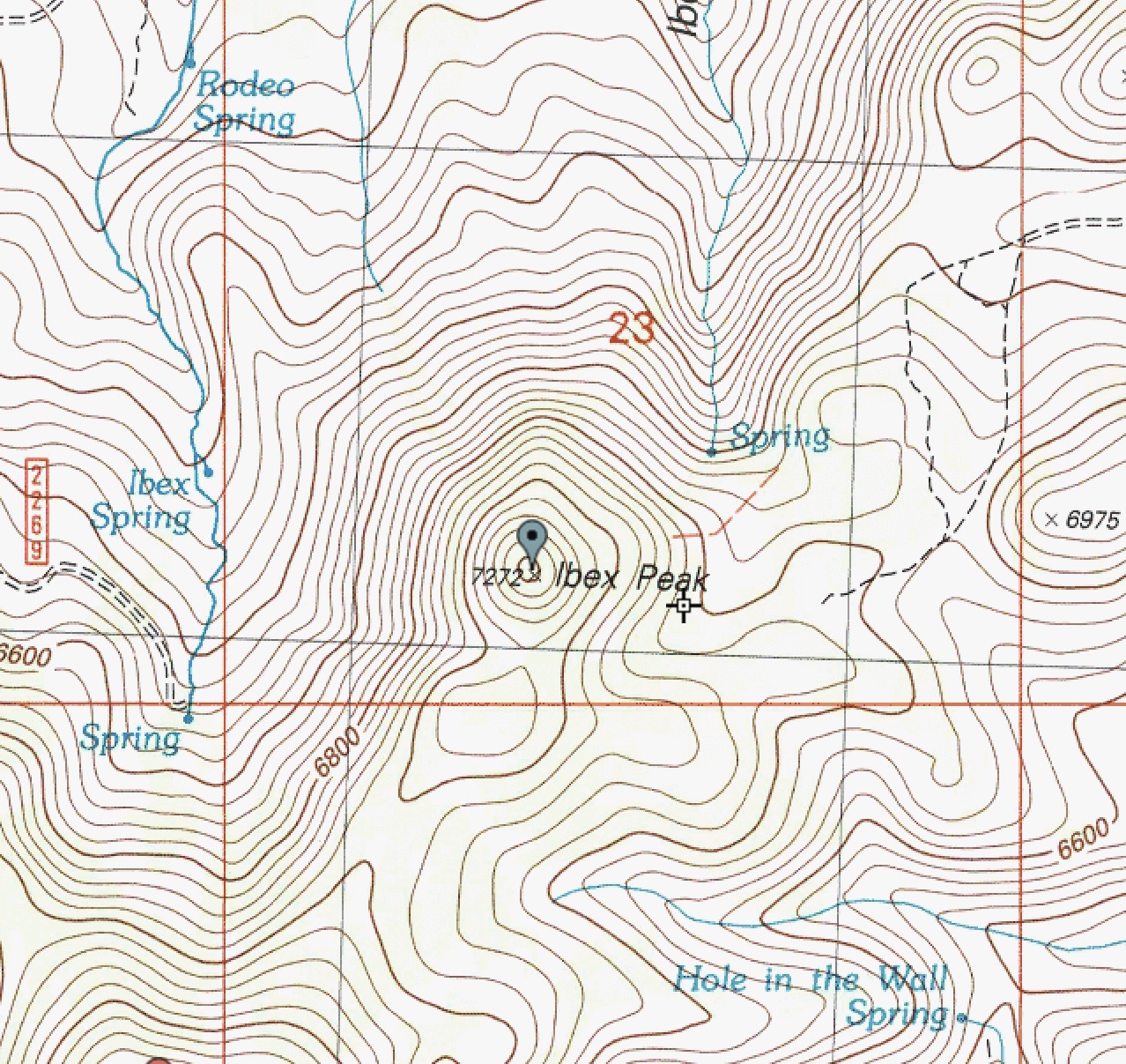
This is perhaps the most perplexing case of all and the most difficult to resolve. What is the correct elevation of a mountain peak with a measured altitude that is inconsistent with the USGS map contour lines? Let’s look at Ibex Peak as an illustration. Ibex Peak is an iconic summit located in the South Hills of Idaho. Here is what the USGS topo map shows:
The measured elevation is 7,272 feet and the summit area is pretty small. However, it is impossible for the elevation to be 7,272 feet since the highest contour line is 7,200 feet. Based on the contour lines, the interpolated elevation is 7,220 feet and the maximum elevation is 7,239 feet. Did the USGS mapmakers mis-measure the point elevation (7,272 feet) or fail to include the 7,240-foot contour line? Who knows? The standard convention in this case is to go with the measured elevation of 7,272 feet and ignore the missing contour line(s).
Summary and Conclusions
We can’t always rely on measured estimates of a mountain’s height. Nor can we always be sure that the measured point is the highest point. But neither should we blindly accept interpolations as surrogates for the real thing. We can’t always rely on subjective determinations of where the highest point is (e.g., the contour line with the greatest surface area above it). Sometimes that methodology is correct, sometimes it isn’t.
The best way to deal with all of the possible inaccuracies and estimates is to stand atop every one of the potential high points on a mountain, JUST TO BE SURE. It’s really that simple.
The two most popular websites for climbers are peakbagger.com and ListsofJohn.com. The methodology each of these websites for determining a peak’s elevation is set out below:
Lists of John’s elevation discussion.Peakbagger’s methodology discussion.
This article from the Idaho Statesman was published on August 1, 1926. In 2018, we know that there are no active glaciers in Idaho. Pettit Lake is the only landmark mentioned in the article, so it is safe to assume that the glacier was located west of the lake. Based on the distance and size measurements set forth in the article as well as the name Snowyside Peak, I think that the North Slopes of Snowyside Peak is a possible location. I added a photo of the North Side of the peak at the bottom of the page. See also The End of the Last Idaho Ice Age by Bob Boyles.
Along with its balmy climate, industrial opportunities, scenery and potatoes, Idaho can also boast of those phenomenal masses of ice, the awe inspiring beauty of which each year entices thousands of tourists to Switzerland. One of the few glaciers in the State of Idaho can be found far into the upper reaches of Idaho’s Alps (the Sawtooths) 20 miles up from Pettit Lake at an elevation of approximately 10,000 feet. Extremely difficult to access and far from the paths of men, this mass of ice is today practically unknown (even to native sons) and has not been named.
The glacier lies in an upland valley. It is oblong in shape and is estimated to be a mile in length and half-mile wide. Due to the probable irregularities of the valley floor, there is no accurate way of determining its supposedly great depth. The surface is rugged, very irregular and slanting.
The claim of this body or ice to the name “glacier” cannot be doubted. It is neither an overgrown snowbank nor the frozen surface of a mountain lake and possesses all glacial properties to the least details. Its interior formation is essentially that or the glacier, being made up of layers of solid lice, which is really frozen snow and seepage water under terrific pressure. At its crest is found the firn, a mass of granular snow which forms the upper part of glaciers. In its surface are crevices, so large and forbidding that as yet no man has dared venture near enough to determine their depth. And, as more substantial proof, it is slowly but inexorably moving, descending between the confining precipices of granite, pushing a moraine (a mass of accumulated debris) ahead of it and leaving a scarred trail on the bedrock in its wake.
The ascent from Pettit Lake to the glacier is so rugged and difficult that only a few more hardy nature-lovers have made the trip. The trail (only a dim outline) is so steep and dangerous that it is necessary to travel practically the entire distance on foot. But, dangerous and exhausting as the trail is, those who follow it to the journey’s end will find themselves amply repaid. To the brave belong the spoils.
Was the glacier located below Snowyside Peak’s North Face?
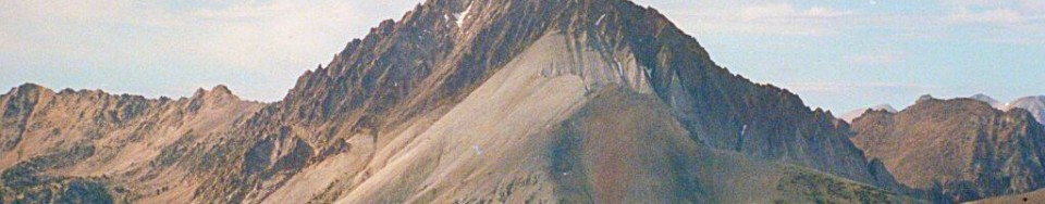
In the 1960s, the American Smelting and Refining Company was preparing to develop an open pit molybdenum mine on the North Side of Castle Peak. The remnants of the company’s extensive mining camp are still standing below the peak. There is a good summary of the dispute on the Boulder White Clouds Council’s website: The Battle for Castle Peak. This battle is briefly mentioned on Page 22 of the book.
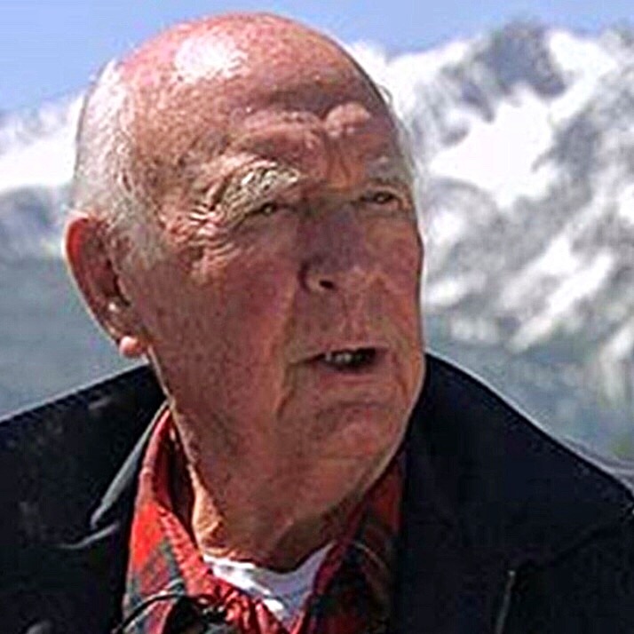
Cecil Andrus
The battle to save the White Clouds was heated and decisive. Cecil Andrus opposed the mine and, in part, won the race for Governor as a result of his stance. Once the mine was stopped, the next battle (creation of the Sawtooth National Recreation Area) took place in Washington, D.C. Idaho Senator Frank Church led the battle in Congress.
This history is extensively covered in many places. I will add a few historical tidbits as I come across them.
This photo was part of an Idaho State Journal article published on July 7, 1969.