Tag: 1920s

  • The Missing Link: Norman Clyde in Idaho

    The Missing Link: Norman Clyde in Idaho

    Idaho is a virtual sea of mountains. While there is no doubt that Native Americans rambled across the state’s mountain summits and that explorers, trappers, miners, ranchers, surveyors and locals were climbing Idaho’s mountains from the time Lewis and Clark first passed through the state, there are few recorded accounts of these early ascents.

    When I wrote Idaho: A Climbing Guide, I noted at the time the second edition was published that “The following [Climbing History] is a thumbnail sketch of Idaho’s mountaineering history, filled with unfortunate, but unavoidable gaps.” In the intervening years, I have searched for additional accounts of Idaho climbers to fill in the gaps. I recently came across a couple of 92-year-old Idaho Statesman articles that answered one of my unanswered questions about the Sawtooth Range.

    The birth of modern Idaho Sawtooth mountaineering has historically been credited to Robert and Miriam Underhill. Robert, a Harvard philosophy professor and an Appalachian Mountain Club member, was a cutting edge American mountaineer in the 1920s and 1930s. Miriam was the top American female climber of her time. They climbed in the Sawtooths in 1934 and 1935 and then published articles in the Appalachian Mountain Club’s journal, Appalachia, in 1934 and 1935. No doubt, these articles awakened the wider climbing community to the Sawtooth’s impressive granite peaks but who told the Underhills about the Sawtooths?

    The Idaho Department of Commerce publicized the scenic beauty of the Sawtooths as early as 1910. However, it is unlikely that the Underhills read about Sawtooth climbing opportunities in an Idaho Department of Commerce brochure or in Idaho Statesman articles, like the the 1927 article “Crown of the Sawtooths” by Bob “Two Gun” Limbert.

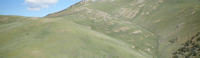
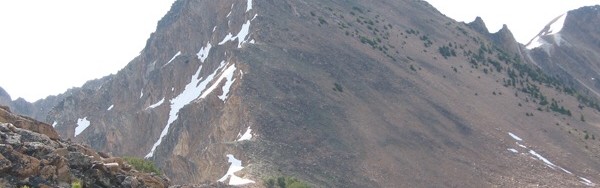
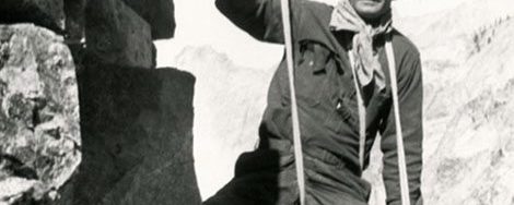
    It turns out that the link between the Underhills and Idaho was Norman Clyde. Norman Clyde (1885-1972) was unquestionably one of the most prolific Sierra Nevada explorers and climbers. He is credited with more than 130 first ascents in the Sierra, has a peak, a minaret and many routes named after him. Less well known are Clyde’s climbing adventures in Montana, Wyoming and Idaho. Yes, Idaho. Although a very obscure fact, in 1927, Clyde climbed in both the Sawtooth Range and the White Clouds.

    Clyde was also a prolific writer. The Bancroft Library at the University of California maintains Clyde’s papers which includes an archive of 1,467 articles. Three of these articles cover Clyde’s visit to Idaho in 1927: An Ascent of Castle Peak; Up and Down Castle Peak; and A Glimpse of the Sawtooth Mountains of Central Idaho. Two of these articles, An Ascent of Castle Peak and A Glimpse of the Sawtooth Mountains of Central Idaho (albeit with a slightly altered form) were published in the Idaho Statesman in 1929.

    Clyde’s visit to Idaho was first noted in a September 10, 1927 news clip in the Idaho Statesman:

    CLIMBS SAWTOOTH PEAKS

    HAILEY — Norman Clyde, who makes a specialty of guiding parties on mountain climbs, is in the Sawtooth country looking for new territory and has finished climbing a number of the major Sawtooth peaks, including some of the White Cloud peaks and Castle Peak. He reports that Castle Peak is not so hard to climb as the Grand Teton, where he conducted a party last year, but is a mountain that will appeal to mountain climbers. Mr. Clyde’s home is at Independence, California.”

    The first Clyde article published by the Statesman was a shortened version of his  longer, unpublished  article, A Glimpse of the Sawtooth Mountains of Central Idaho. The Statesman article was entitled A Southerner’s Glimpse of the Sawtooth Mountains. It appeared on June 2, 1929. This article recounted his ascent of Decker Peak and described the rugged crest.

    Arriving at the crest of the ridge, I came upon a trail leading toward the summit of the range. This I followed until it terminated near timber line. To the southwest, beyond rocky cirques, the summit of Mount Decker came into view. Here it was necessary to drop down several hundred feet in order to avoid an impassable crag.”

    Despite suffering from a violent toothache, Clyde pressed on. He recounted:

    As I advanced, more and more of the rugged crest of the range came into view. After surmounting several craggy and glaciated pitches, I reached a talus slope just below the summit. Seized with the elan that fills me when nearing the summit of a mountain, I soon traversed this and scrambled up to the crest of a narrow arete which I followed to the highest point of the peak.”

    Clyde then described the view in terms that make climbers grab their packs and head for the mountains:

    The panorama that lay outspread around me was thrilling. For a score of miles in either direction extended the crest of the Sawtooths—a maze of craggy peaks, deep cirques, narrow ridges and pinnacled knife-edges. Azure lakes lay ensconced in verdant timbered bowls of the lower basins while others lurked in rocky cirques, tinged with a shade of turquoise; one with an indescribable amethystine hue. Masses of snow clung here and there to precipitous slopes, while several remnants of almost vanished glaciers appeared in sheltered depressions. Fleecy clouds floated slowly past, crossed the Sawtooth Valley and gathered about Castle peak and the White Cloud peaks. In every direction, range after range extended to the horizon. To the north, the broken crest of the Sawtooths continued for a considerable distance. To the southeast, undulating lines varied by several precipitous mountains faded away in the distance. To the east, beyond the Sawtooths were the high masses of the Boulder and Hyndman groups .”

    The second of Clyde’s three Idaho articles, An Ascent of Castle Peak, was published in the Idaho Statesman on June 9, 1929. His article doesn’t mention if he found evidence of a previous ascent but does constitute the earliest description of a climb of the White Cloud Peaks giant.

    Clyde made his base camp for his Idaho explorations at the F.W Shaw Ranch near Obsidian. He undoubtedly learned about the lay of the land from his hosts. Following, this advice, he approached Castle Peak via Fourth of July Creek. He climbed an unnamed peak along the way, probably the still unnamed Peak 10405, and then made his way of into Chamberlain Basin and the lake below Castle Peak’s South Face. The next day he climbed up the face, writing:

    Leaving camp early on the following morning, I was soon trudging up the steep slope that rises to the east of the lake to an elevation of about 1,500 feet above it. As I surmounted it, I came into full view of Castle Peak, towering above a lake-studded basin a few hundred feet below me. A number of steep chutes seemed to rise almost vertically toward its summit, which appeared to consist of a series of pinnacles of almost equal height. One chimney, just to the left of the summit almost reached it but, as the apparently perpendicular wall above it appeared to possess few holds, I decided to go to the east and ascend its Southwest Shoulder or attempt to find a way up–another.”

    His account into the unknown continued:

    “. . . Crossing above one of them, I made my way up a a broad stretch of talus and then up a chute, broad and gently sloping at first, but soon narrow and steep. After reaching its head by a somewhat difficult scramble, I crossed one narrow arete to another and went toward what appeared to be the summit, but upon reaching it I found it to be only a point on a jagged knife-edge, with another higher one to the east, beyond a deep gash in the arete. Dropping down several hundred feet, I quickly climbed to the top of it. Probably the highest point on the mountain, but several pinnacles of almost equal or possibly greater height were seen to the east. . . .”

    Thus, Clyde was confronted with the same question that still confounds climbers 92 years later: which point on Castle Peak’s ragged summit ridge is the true summit? He continued:

    To make certain of not missing the highest point of the mountain, I proceeded to climb the other pinnacles. As I worked my way along the cliff, surmounting one after another of them, I found interesting but not very hazardous climbing, except possibly in one instance where I carelessly stepped on a loose mass of rock that suddenly gave way. Fortunately I had a good handhold, and after hanging in partial suspension for a few moments I was able to proceed along a narrow shelf. Eventually I came to the last of the higher pinnacles.”

    No doubt the Idaho Statesman’s publishing of Clyde’s articles and similar articles gave local climbers further reason to explore the Idaho mountains.  How did Clyde inspire the Underhills to travel form their home at Harvard to Idaho?

    Clyde was a member of the Sierra Club. In 1931, Sierra Club officer Francis Farquhar invited Robert Underhill to the Sierra Nevada to teach the latest techniques of roped climbing to Sierra Club members. Clyde was part of this group. Given Underhill’s drive to explore mountains world wide, there can be no doubt that he and Clyde exchanged climbing stories over a campfire.

    The link between Clyde and the Underhills led to the opening of the Sawtooth Range to a cosmopolitan, out of state, array of climbers including Fred Beckey, Luis Stur, Gordon Webster, Steve Roper, Bill March, Jeff Lowe and the Iowa Mountaineers. Idaho climbers followed these climbers and established themselves in the Pantheon of Sawtooth Climbers. Lyman Dye started the first Sawtooth climbing guide service and he was later followed by Kirk Bachman who established Sawtooth Mountain Guides. Reid Dawdle, Ray Brooks, Dave Bingham, Kevin Swigert, Jeff and Kelly Rhoads and many others redefined and refined the Sawtooth climbing ethic which started with Norman Clyde’s 1927 visit.


    Read more about Norman Clyde in Wikipedia and in the Adventure Journal.

  • Appendicitis Hill and T.M. Bannon

    Appendicitis Hill and T.M. Bannon

    On February 26th, 1926, the Sunday Idaho Statesman published the following report by E.S. Crawford describing the origin of the name Appendicitis Mountain, now Appendicitis Hill. Bannon’s extensive surveying contributions to Idaho Surveying are discussed on Pages 14 and 15 of the book.


    Appendicitis Case – Responsible for Mountain’s Name

    Answering a query of The Statesman several weeks ago as to how “Appendicitis Mountain” acquired its name, E.S. Crawford of Antelope Valley sends the Arco Advertiser the following story which adds a bit to Idaho history:

    “What is now known as Appendicitis Mountain forms part of the East Canyon Wall of Antelope Valley, and is one or Antelope’s beauty spots. It is steep and rugged and rises almost from the creek bed. From the top of this mountain looking eastward, Moore and Arco can be seen.”

    “In the Spring of 1915, the Hanson brothers (from Lewiston, Idaho) came through this section of the country, building monuments on the highest peaks of the mountain ranges. Among these peaks are Old Smiley, Mount Shelley, what is now known as Appendicitis Mountain and Mount McCaleb.

    “During the Summer and Fall of the same year, T. M. Bannon (a geographic surveyor from Washington, D.C.) and his helper, Mr. Tucker (from New Jersey), George Adams (of Challis, Idaho) and another man from Colorado (who acted as cook for the party), came through, making maps and prints of the airline distances between these mountains.

    “In the early part of September 1915, they camped at the foot of this mountain, in the grove of trees which is on the Crawford Ranch. On the second day of their stay, a trip was made to the mountain top. But as the fog and haze were so thick, they were unable to make the survey and planned on making another trip the following day. This trip, though they did not know it at the time, was never to be made by Mr. Bannon, for that very night he became suddenly ill and passed a night in pain from which morning brought no relief.

    Stricken With Appendicitis

    “About 8:00AM the next morning, they asked for the best doctor in Mackay and Dr. N. H. Farrell was called. Doctor Farrell pronounced the trouble as appendicitis and advised the removal of Mr. Bannon to the Mackay Hospital. As cars were few in the Antelope Valley, a bed was made in the back of a white-topped buggy and a trip of 20 miles, over not any too smooth roads, was made. This was Doctor Farrell’s first operation case after coming to Mackay, which proved to be a serious as well as a successful operation and Mr. Bannon (in writing to Mr. Crawford after he had recovered returned to his home in Washington, D.C.) wrote very highly of Doctor Farrell and the nurse, Miss  Hendickerson.”   

    “Although lung trouble set in after the operation and Mr. Bannon had to spend a great deal of time in Ashville, North Carolina, he finally recovered from that and died from some minor ailment in either 1918 or 1919. In one of his letters to Mr. Crawford, he told of naming this mountain and having it put on record in Washington, D.C. as Appendicitis Mountain.”

  • An Overview of the Lookouts in the Salmon National Forest by Bing Young (1982)

    An Overview of the Lookouts in the Salmon National Forest by Bing Young (1982)

    According to A History of the Salmon National Forest, by 1916 there were two lookouts in the Salmon National Forest, at Blue Nose and Salmon City Peak (later given the name “Baldy“). It was assumed that most of the forest could be seen from these two points. Cathedral Rock, in the Bighorn Crags, was also used at times to see the Middle Fork area, and there was  apparently even a telephone line at one time to Cathedral Rock. [Footnote 7: Personal conversation with Mr. Howard Castle who remembers being told about this phone line. The author seriously doubts, however, that the line was ever extended to the top of the mountain, though it may well have existed at the base of Cathedral Rock. Cathedral Rock is an extremely sheer crag-type mountain not to be climbed except by professionals, which no doubt affords a great view of the Middle Fork area and which would have been left blind by just the use of Baldy and Blue Nose.]

    But the effect of the Weeks Act was to change that situation. The 1918 Forest map lists Taylor Mountain, Lake Mountain, Haystack Mountain, Blackbird, Sagebrush Mountain , and Ulysses as lookouts. Apparently Blue Nose was also still used.

    The Blue Nose lookout is unlocked and in need of some serious repair work.
    The Blue Nose Lookout is unlocked and is in need of some serious repair work.

    At this point, there were few lookout buildings as we know them today. As late as 1924, lookout structures had been built only on Long Tom, Baldy, Taylor, Stein, and Blackbird Mountain. Most of the lookout “houses” built at that time were extremely small—most 9‘ x 9’—and in 1924, only Blackbird Mountain had the more typical 14′ x 14′ structure of  today’s lookouts.

    Rather than live in lookout buildings, most lookouts were camped near mountain peaks during the critical fire period. Many of those lookouts were also “smokechasers,” that is after finding a fire, the lookouts would take off to put it out. This was particularly the use before telephone lines were installed. Lookouts were thus placed in many locations in the forest, often varying from year to year. Since no visibility maps (those indicating the area seen from a lookout) were then available, lookout stationing was not planned in a very organized manner.

    It was decided about this time that some lookouts should be considered “primary” and manned for the entire fire season at all times; “secondary”, which would be manned only for a month in the worst part of the fire season ; and “tertiary” or third line lookouts, manned only in bad fire years. In 1923, the Salmon National Forest’s primary lookouts were Taylor Mountain, Blackbird, Blue Nose, and Long Tom. Secondary lookouts were Middle Fork Peak, Two Point, and Granite Peak. Additional smokechasers were stationed at various paces in the forest, including Lake Mountain, Sagebrush, Haystack, and Sheepeater Point. Lookout selection was not made with a lot of information and choices varied from year to year.

    In 1926, the first visibility maps were made of many peaks of the forest. Henry Shank, in an effort to better select the primary and secondary lookouts, tried to plot the area visible from each lookout station. The 1926 map indicates Lake Mountain, Stein, Haystack, Sheepeater, Two Point Peak, and Sagebrush as primary lookouts. I assume that Taylor Mountain and Blue Nose were also still in use, as they appear on later maps.

    By 1929, 19 points in the forest had either a lookout or a dual/smokechaser. The year 1929 was one of  the worst fire years in the recorded history of the Salmon National  Forest, particularly with the Wilson Creek Fire. In order to avoid large conflagrations of the size of the Wilson Creek Fire, the early detection system needed additional improvement. This determination to improve detection, coupled with the surfeit of workers made available by the Great Depression, enabled the Forest to initiate a massive lookout construction program. By 1932, 23 lookout points were in operation in the Salmon National Forest, with selection and construction contemplated for 7 more. Smokechasers were also stationed at the Indianola, Hughes Creek, and Yellowjacket Guard Stations.

    1935 appears to have marked the time when lookouts reached their peak. Thirty-four lookouts then stood as sentinels over the forest. Buildings had been set up on nearly all of the sites, even though many weren’t primary lookouts. All seemed to be hooked up to telephones.

    Just when the lookouts began their decline is not clear, but it is known that by the early 1940s some were being abandoned—particularly early ones like Duck Creek Point and Taylor Mountain. Perhaps this was partly due to the war—there weren’t enough men around to staff all of the lookouts. This is when women began to serve as lookouts. Money was short and it was recognized that there was much visibility duplication in the lookouts.

    The remains of the Taylor Mountain lookout.
    The remains of the Taylor Mountain Lookout.

    Even without the war, the decline of the lookout system was inevitable. As early as the 1920s, Region I (Missoula, Montana) had been experimenting with the airplane as a fire detection tool. If anything, the war probably delayed the demise of the lookout system, as airplanes, pilots, and the like were needed more in the war that they were in experimenting with forest fire detection.

    After World War II and the Korean conflict, aerial detection began to change the scene. Smokechasers became smokejumpers—at least in the more remote areas—and airplane “watchdogs” replaced many lookouts. Most lookouts faded out gradually one or two at a time until in 1982 there were only 6 of the original number remaining: Long Tom, Stormy Peak, Sagebrush, Stein Mountain, Middle Fork Peak and Sheephorn. Butts Point was not manned in the 1982 season, but the North Fork Ranger District has not given it up, as it is still considered to be of primary importance. Fire management personnel have indicated that it is unlikely that any of the others will be used again.

    Middle Fork Peak viewed from Peak 9101.
    Middle Fork Peak as viewed from Peak 9101.

    An interesting trend in the site selection of lookouts was the preference to use the highest peaks in the Forest. Pre-1930 lookouts included Taylor Mountain, Blackbird, Lake Mountain, Cottonwood Butte, Duck Creek Point, Two Point Peak and Middle Fork Peak—all over 9,000 feet. Post-1930 lookouts included Granite Mountain, Jureano, Sheephorn, Hot Springs and Butts Point. Nearly all of the post-1930 lookouts are under 8,500 feet and most are less than 8,000 feet.

    This change in trend was probably because the high lookouts may cover great distances, yet they are often too high for visibility of the high-hazard country of lower elevations right under them. Indeed, most of the high lookouts have no view of large or important drainage bottoms. The Forest is hampered by the problem of its extreme verticality. Canyons are generally narrow, steep and very deep. This has made it difficult to use the “highest peaks” as lookouts as is done by many other Forests.

    In the early 1930s, forests were required to have 80 percent lookout coverage of the Forest’s high fire-hazard acreage. The only way to see much in the rugged Salmon River country was to “come down” in elevation. Thus, later lookouts like Granite Mountain and Sheephorn don’t have the horizontal viewing distance that some of the older lookouts do, like Blue Nose and Taylor Mountain. They do, though, afford  excellent views of specialized high-hazard drainages.

    Other problems encountered by the high peaks were: the great distances to water which lookouts had to hike to daily; great distances to “climb down” to a fire; the problem that high lookouts were often “fogged in” in the morning (one of the best times to find fires); and rugged and costly to packers supplying the high lookouts.

    Today’s lookouts have been selected by the Forest Service through a long process of elimination. They have excellent views of high-hazard drainages and nearly all report fires every year.

  • Before it was Stack Rock

    Before it was Stack Rock

    This August 19, 1922 article from the Idaho Statesman called “Castle Rock” what we now know today as “Stack Rock.”

    Back to Stack Rock


  • A Sawtooth Range Glacier

    A Sawtooth Range Glacier

    This article from the Idaho Statesman was published on August 1, 1926. In 2018, we know that there are no active glaciers in Idaho. Pettit Lake is the only landmark mentioned in the article, so it is safe to assume that the glacier was located west of the lake. Based on the distance and size measurements set forth in the article as well as the name Snowyside Peak, I think that the North Slopes of Snowyside Peak is a possible location. I added a photo of the North Side of the peak at the bottom of the page. See also The End of the Last Idaho Ice Age by Bob Boyles.


    Along with its balmy climate, industrial opportunities, scenery and potatoes, Idaho can also boast of those phenomenal masses of ice, the awe inspiring beauty of which each year entices thousands of tourists to Switzerland. One of the few glaciers in the State of Idaho can be found far into the upper reaches of Idaho’s Alps (the Sawtooths) 20 miles up from Pettit Lake at an elevation of approximately 10,000 feet. Extremely difficult to access and far from the paths of men, this mass of ice is today practically unknown (even to native sons) and has not been named.  

    The glacier lies in an upland valley. It is oblong in shape and is estimated to be a mile in length and half-mile wide. Due to the probable irregularities of the valley floor, there is no accurate way of determining its supposedly great depth. The surface is rugged, very irregular and slanting. 

    The claim of this body or ice to the name “glacier” cannot be doubted. It is neither an overgrown snowbank nor the frozen surface of a mountain lake and possesses all glacial properties to the least details. Its interior formation is essentially that or the glacier, being made up of layers of solid lice, which is really frozen snow and seepage water under terrific pressure. At its crest is found the firn, a mass of granular snow which forms the upper part of glaciers. In its surface are crevices, so large and forbidding that as yet no man has dared venture near enough to determine their depth. And, as more substantial proof, it is slowly but inexorably moving, descending between the confining precipices of granite, pushing a moraine (a mass of accumulated debris) ahead of it and leaving a scarred trail on the bedrock in its wake.  

    The ascent from Pettit Lake to the glacier is so rugged and difficult that only a few more hardy nature-lovers have made the trip. The trail (only a dim outline) is so steep and dangerous that it is necessary to travel practically the entire distance on foot. But, dangerous and exhausting as the trail is, those who follow it to the journey’s end will find themselves amply repaid. To the brave belong the spoils.

    Was the glacier located below Snowyside Peak’s northern face?
    Was the glacier located below Snowyside Peak’s North Face?


  • Which Idaho Peak is the Highest?

    Which Idaho Peak is the Highest?

    In the early 1920s, Hyndman Peak was considered Idaho’s highest summit. After an article (not yet located) in the Idaho Statesman declared Hyndman the highest, a protest was sent to the Statesman and subsequently published by the paper. The protest, set out below, declared Patterson Peak in the White Clouds as the highest Idaho summit and claimed it was 13,000 feet high. Patterson is far from a dominating summit and the article, possibly written in jest, either ignores nearby Castle Peak, which lords over every other White Cloud summit or, as the hand-drawn map implies, is actually mistaking Patterson Peak for Castle Peak.


    Click on Photo to enlarge.

    SOMEWHERE in Central Idaho (in the southwest part of Custer County to be exact), there is a modest, unassuming mountain. Patterson is the name and Patterson never has been one to go out of his way in search of notoriety. He knew his merits, did Patterson, and was satisfied even if the world in general ignored him. 

    And to the southeast another mountain rears his head. There is nothing unassuming about the latter, Mount Hyndman. He claims to be the tallest fellow in Idaho, and broadcasts his claim to the world. There is something about his arrogant bearing, the sheer sweep of his cliffs, which proclaims his worth to a wondering world. And the world watching him, decided he knew where of he spoke. On his massive shoulders was pinned the toga and thousands visited him. 

    But there were those in the world who were determined that justice should be done. Perhaps there is a wee bit, too, of disgust at Hyndman’s overweening pride. At any rate, one day they started to broadcast. 

    The Statesman: On the unimpeachable authority of United States Geological Survey figures, proclaimed one day that Hyndman was the highest mountain in Idaho and one of the three or four highest in the northwest. 

    “And that’s just where you’re wrong,” quoth some unidentified correspondent. “There’s a taller baby yet, Patterson Peak. That’s no apple sauce and we can prove it.” 

    Forthwith the scoffers at Hyndman’s greatness produced a sheet of paper—nothing less than a list of the highest peaks is Idaho. There was Hyndman, all right—12,078 feet high, just as The Statesman had said he was, but there also was Patterson, an opposite the name of this shy, retiring violet was written “altitude 13,000 feet.” 

    And there the matter rests. Who invaded the solitude of Patterson Peak’s ages-long retreat, applied the unromantic baronet and the matter-of-fact triangulation formulas, stripped him of his mystery and his romance, and put him down in cold, hard type.

    Who had the temerity to challenge the hitherto undisputed reign of Mount Hyndman, arrogant and bold, in behalf of this diffident pretender, whose only claim lies in the support of his friends? Truly it will be a battle of the giants this struggle for the throne of Idaho. Rumor hath it that Patterson himself, though unassuming in demeanor, is not lightly to be scaled, not to be crossed with impunity. And to the qualities of Hyndman all will bear witness.

    The thing might be easily decided were there photographic studies of the new claimant extant. One could gaze on his profile, compare it with the lordly majesty of Hyndman, and award the palm to the most King-like. It mightn’t be scientific but it would be monstrously satisfying.  

    Unfortunately, Patterson in his retirement has attracted few visitors. Nobody has recognized his regal descent or is it ascent and his lineaments, if reproduced on paper, are unrecognizable from those of a score of peaks about him. Just one remedy seems possible. Engineering parties might be sent out to make accurate check of all the data on both, then  decide which is the true monarch. Till that day comes, each will have his champions and wordy will be the battle.